Subdivisions of Shireroth
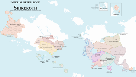
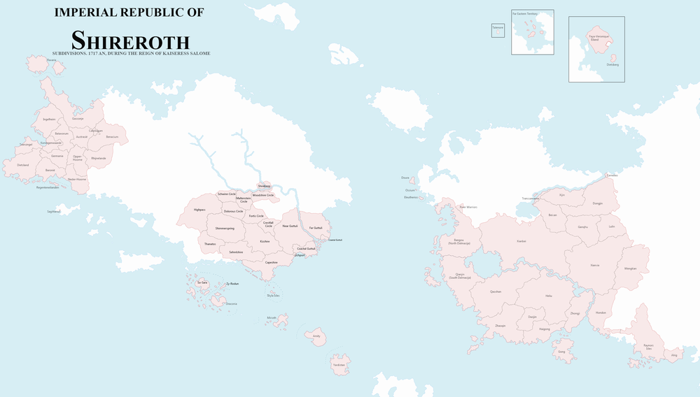
The Imperial Republic of Shireroth is governed through a number of subdivisions, of which the Duchy and Imperial Dominion is the largest administrative unit. While informally, those are often referred to as Imperial States. These Duchies and Dominions are in most cases further divided in a number of Provinces, Counties, Circles or Districts. Each territory retains a strong cultural identity, which place them sometimes at odds with central authorities in Shirekeep.
Top-tier subdivision
Duchies are the largest subdivisions possible. Prior to the Kalirion Fracture, those were divided into Baronies and further into Counties along old feudal lines. They are generally ruled by a Duke. An exception is the Kingdom of Batavia, the protectorates and territories which are ruled directly by the Golden Mango Throne or received a special status.
Current top-tier subdivisions
- Shirekeep
- Kingdom of Batavia, Imperial Dominion.
- Duchy of Brookshire
- Duchy of Kildare
- Duchy of Modan
- Duchy of Guttuli
- Duchy of Jingdao
- Duchy of Jinkeai
- Duchy of Outer Antya
- Duchy of Raynor's Isles
- Protectorate of Alrig
- Protectorate of Talenore
- County of the Skyla
- Emirate of Sathrati
- County Palatinate of Draconia
- County Palatinate of Kezan
Former Duchies
- Qyzylqaystan (short, between 1710 - 1711)
- Yardistan
- Elwynn (previously Froyalan)
- Straylight
- Arminy
- Antica
- Goldshire (Northshire)
- Lothlaria
Second-tier subdivisions
- See also: 1715 Shireroth census
The Imperial States are in turn divided in a larger number of smaller, easier to rule, subdivisions. Depending on the State, these second-level subdivisions are governed by Counts, Barons,... according to the feudal ways of the past, or by governors who may - or may not - be appointed or even elected by the people or local assemblies.
| Imperial State | Province/Circle/… |
|---|---|
| Shirekeep | Inner City |
| Northshire South | |
| Lichkeep | |
| Cabbagefall | |
| Alrig Protectorate | |
| Batavia | Austrasië |
| Baronië | |
| Batavorum | |
| Benacium | |
| Catologum | |
| Dietsland | |
| Faya-Veronique Eiland (Faya Veronique Island) | |
| Gasconje (Gascony) | |
| Germania | |
| Ingelheim | |
| Neder-Hoorne | |
| Opper-Hoorne | |
| Ravaria | |
| Regenteneilanden (Regent Islands) | |
| Rhijnelande (Rhineland) | |
| 's Koningenwaarde (Kingsworth) | |
| Transingel | |
| Brookshire | Woodshire Circle |
| Maltenstein Circle | |
| Schwinn Circle | |
| Dolorous Circle | |
| Fortis Circle | |
| Crestfall Circle | |
| Draconia | |
| Guttuli | Near |
| Far | |
| Coastal | |
| Jingdao | Far Eastern Territory |
| Dazijin | |
| Jinkeai | Beixan |
| Camoleo | |
| Dongjin | |
| Ganqhu | |
| Lulin | |
| Transsamarne | |
| Xijin | |
| Kezan | Eleutherios and Akis |
| Ossium | |
| Hawshire Free State | |
| Kildare | Dalmacija (Dalmatia) |
| Gong | |
| Haigong | |
| Heliu | |
| Hondon | |
| Qaoshan | |
| River Warriors' AR | |
| Xianbei | |
| Zhaoqin | |
| Zhongji | |
| Modan | Kizshire |
| Capeshire | |
| Sehmlshire | |
| Shimmerspring | |
| Thanatos | |
| Outer Antya | Mengtian |
| Xianxia | |
| Sathrati | Yardistan |
| Mirioth | |
| Amity | |
| Zy-Rodun | |
| Skyla | |
| Sagittarius | |
| Talenore | |
| ALL OF SHIREROTH |
Work in Progress
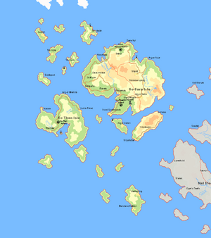
Duchy of So-Sara (Islands of the Horse Lords) | |||||
|---|---|---|---|---|---|
| Duke | |||||
| Flag | Subdivision | Ruler (representing the Golden Mango Throne) | Population (1739 AN) | Important Noble House(s) | |
| So-Sara Isle | |||||
| So-Than Isle | |||||
| Total Population | |||||
| |||||||||||||||||||||||||||||||||||||

