Sanpantul
| Sanpantul State of Sanpantul 三帆都国 (Sanhanto-koku?) | |||
| |||
| Motto: Long live Sanpantul! (三帆都万歳!, Sanhanto Banzai!?) | |||
| Anthem: 1001 Nights of Spatull 千夜一夜三三帆都 National anthem | |||

| |||
| Map versions | 16.5.6 - | ||
| Capital | Kipei (喜兵, Kippei?)
| ||
| Official language(s) | Sanpogo | ||
| Official religion(s) | Secular | ||
| Demonym | Sanpanese | ||
| - Adjective | Sanpanese | ||
| Government | Unitary parliamentary constitutional monarchy | ||
| - Emperor - Queen |
Takashihito (隆仁) | ||
| - Prime Minister | xxxxx (xxxxx) | ||
| Establishment | 1675 | ||
| Area | 53,528 km2 | ||
| Population | 21,818,170 (census of 1752)
| ||
| Active population | 1 | ||
| Currency | Sanpanese Yen (old), Muhar (₼) (new) | ||
| Calendar | Norton calendar | ||
| Time zone(s) | CMT+4 | ||
| Mains electricity | 230/400 V - 50 Hz | ||
| Driving side | left | ||
| Track gauge | General railways: 1,067 mm (3 ft 6 in) High-speed railways: 1,435 mm (4 ft 8 1⁄2 in) | ||
| National website | none | ||
| National forum | [1] | ||
| National animal | Crane | ||
| National food | Sushi | ||
| National drink | Sakurayu | ||
| National tree | Cherry | ||
| Abbreviation | SPT, SP | ||


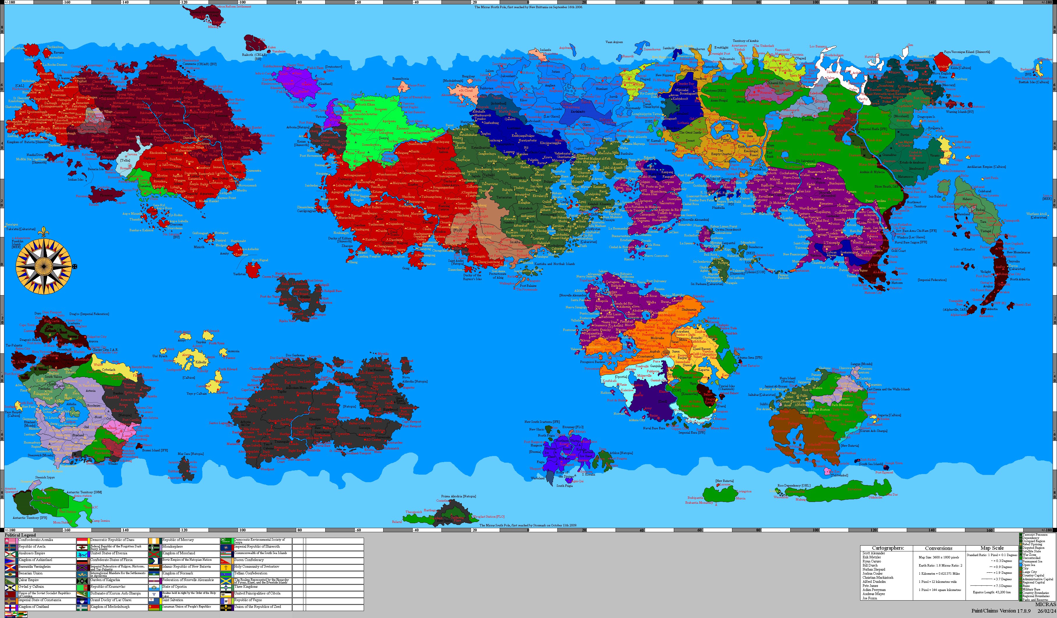
Sanpantul (/sˈænpɐntˌʌl/) (Japanese:三帆都国 Sanhanto-koku), officially the State of Sanpantul, unofficial Second Sanpanese State or only Sanpantul, is a nation located on Keltia. It is located on East Sandwich island, approximately 240 km north of Sri Pashana, and on West Sandwich island. It is also informally called the Sandwich Islands or the Three Boats Country. Its royal capital is Kipei, although some administrative units are located in Pitomachi. Sanpantul comprises twenty-five prefectures and geographically comprises 8,137 islands, including the Sandwich Islands (east and west) and the Prince Islands, a group of volcanic islands of varying sizes. The majority of the islands are located within the Prince Islands (6,306). Sanpantul is located precisely east of the Skerry Islands and west of the Wilhelm Islands. The most important cities in Sanpantul are Kipei, Ofū, Ogimi, and Miyaji. Sanpantul is located at its westernmost point Kimokumo Lighthouse, easternmost point Aridatori Atoll (part of Wilson Archipelago), northernmost point Narahama Island (part of Koshimeguri Islands, and southernmost point Fujihoro Island (part of Prince Islands. With a population of just over twenty million, the vast majority of Sanpantul resides in East Sandwich. The most populous city in Sanpantul is the capital, Kipei. 90.1% of Sanpantul's urban population lives in the city, while 9.1% lives in rural areas. The largest ethnic group in Sanpantul is the Sanpō, who constitute 90% of the island's population. The second largest ethnic group is the Xiangis, of Sino-Keltian origin, making up 4%, followed by the Thracis and Sicilians. In addition, there are 2,337 Aboriginal people on the island, as well as other groups of immigrants who have lived there for centuries, including the Brettish, Natopian, Elwynnese, and Batavian. Therefore, Sanpantul can be described as ethnically diverse.
Evidence of life on the Skerry Isles, where Sanpantul is located, dates back at least 50,000 years. The Proto-Dromosker peoples completely dominated the islands until around -6000 AN. However, the islands were occupied by numerous peoples, and it was during this period that the first permanent settlements on Skerry began to emerge. The earliest record of the presence of the Sanpōs, the main ethnic group of Sanpantul, dates back to the 10th century. Between the 10th and 14th centuries, a series of shogunates composed of mercenaries formed on the Sandwich Islands, disappearing by the end of the 14th century. Treesian, Brettish and Nova English rule, beginning in the 15th and 17th centuries, brought another culture to the islands, leading to the formation of the Anglo-Skerry culture. The colonies on Skerry were more of an overseas colony than a mainland colony. During the 16th and 17th centuries, the islands were occupied by various nations, the most notable being Antica, Elwynn, and Natopia. Following the collapse of the Skerry Isles, a Natopia colony, in 1652 AN, several shogunates attempted to re-establish themselves on the islands but were repelled by the Brettish, leading to Coastalis's dominance over the entire Sandwich Islands in 1658. After Coastalis's fall in 1667 AN, shogunates were re-established, eventually forming an informal, loose confederation. The shogunates controlled the Sandwich Islands, Taras, and Duras to the north, but were later pushed back by the native population as far as East Sandwich, where the territory was partitioned. This expulsion formed the basis of the old prefecture map, which was used until 1682 AN. In 1669 AN, the Spider Army, loyal to the Tonugawa Dynasty, declared war against all shogunates, Dromoskers, and Coastalis rebels. On June 15, 1675, Sanpantul was officially recognized by the MCS. Over the next fifteen years, the island's economic level improved significantly. In 1687 AN, the plan to gradually relocate Sanpantul to the former Beneluccas territories was formalized. After the 1692 Tortuga Earthquake, Sanpantul collapsed and was occupied by Batavia. In 1702 AN, East Sandwich was ceded to Çakaristan, and Sanpantul was re-established. In 1704 AN, Sanpantul gained further autonomy. In Template:An, Victory Banner seized power, leading to the Sanpo-Çakar War. The war, which lasted from 1716 AN to 1720 AN, ended with the Treaty of Cenfae, incorporating West Sandwich into Sanpantul and ending its autonomy. A drought struck Skerry in mid-1720, preventing the rice crop from being harvested until late 1720s, making Sanpantul even more dependent on Çakaristan. The Rikuto's Rebellion of 1728 AN led to the Sanpantul Referendum of 1729. Economic growth was quite rapid from the referendum until the Recession of 1737, after which economic growth slowed. In 1742, Sanpantul held a second referendum, and in 1744 AN, Sanpantul officially became independent. An application was made to the Xaiville Convention in 1729 AN but was vetoed.
Sanpantul's official form of government is a unitary parliamentary constitutional monarchy. Sanpantul is considered one of the most democratic countries in the Micras region. Despite its small size, Sanpantul has considerable development potential and is a member of the Micras Trade Organization. Sanpantul is a signatory to all treaties except MIPPA. It also has trade agreements with countries sharing its maritime border. Sanpantul is characterized as a fully-fledged welfare state. Citizens enjoy a long life expectancy, and the country is highly developed in terms of gender equality, minority rights, socioeconomic welfare, and the education system. Sanpantul is considered one of the leading countries in Micras in terms of GDP. Citizens are granted equal citizenship, the right to housing, free access to healthcare, free education, and social assistance. Sanpantul invests heavily in technology and automobiles, and its products are exported in large quantities to several major countries. Kipei is also recognized as an important cultural city in Western Celticia. Sanpantul also hosted the 2020 EMU Championships.
Etymology
To be IRL, the first country's name was Spatull, and Samet came up with it. Spatull's location was planned at the northern ends of the South Island, and the flag was almost identical to the flag of the Maya civilization. Later, Alperen designed the seal and later arranged a new location in the Skerry Islands. The name was changed to Sanpantul after the Spatull's position changed. Later, Samet proposed a flag used by the Sanpantul Communist Party, but Alperen did not accept it.
Alperen thought a lot about the name change. Alperen was pondering the meanings of kanji and Japanese words at that time, he was inspired by the boat called sampan at that time and put the suffix -tul at the end. Later this name passed to Sanpanese as Sanhanto. Then, during the rule of Çakaristan, Alperen made minor changes to update the old knowledge, such as the Kanjiization of Sanhanto. San means three and the kanji for Hanto is actually a male name. Alperen Kanji took a look at the name and found a Kanji meaning People of the Beach. It made the most sense to Alperen, and he immediately Kanjilized the name. Sanhanto means Three Sea People in Kanji. Interestingly, it's a coincidence that the Spatull project used to be for three but split up a long time ago.
Another reading of 三帆人 gives the meaning "three sails", thus making Sanpantul the country of the three sails.
Demographics
Ethnic groups
History

|
This article or section is a work in progress. The information below may be incomplete, outdated, or subject to change. |
| History of Sanpantul | ||
|---|---|---|
| Unknown | 1.5 - 2.0 | |
| Free Republic | 2.0 - 3.5.0 | |
| Treesia and Fabon | 3.5 - 4.7.2 | |
| Treesia | 4.7.2 - 6.7.0 | |
| Apollo Foundation | 6.7.0 - 6.7.7 | |
| Green | 6.7.7 – 6.7.9 | |
| Treesia | 6.7.9 - 6.8.6 | |
| Treesia (part of Grand Commonwealth) | 6.8.6 - 8.0.1 | |
| Green | 8.0.1 - 9.2.0 | |
| New Brittania | 9.2.0 - 9.5.0 | |
| Alexandria | 9.5.0 - 10.0.0 | |
| Kataria | 10.0.0 - 12.4.0 | |
| Green | 12.4.0 - 12.7.0 | |
| New Brittania | 12.7.0 - 13.1.1 | |
| Riponia (as Nova England SAR control) | 13.1.1-13.4.2 | |
| Green | 13.4.2 - 13.4.3 | |
| Nova England | 13.4.3 - 14.8.0 | |
| Green | 14.8.0 - 14.8.4 | |
| Antica (as Kaikias-Overseas colony) | 14.8.4 - 15.0.6 | |
| Elwynn (as Kaikias-Overseas colony) | 15.0.6 - 15.1.6 | |
| Aryasht (as Kaikias-Overseas colony) | 15.1.6 - 15.2.9 | |
| Green | 15.2.9 - 15.4.1 | |
| Natopia | 15.4.1- 16.0.0 | |
| Green | 16.0.0-16.1.3 | |
| Coastalis | 16.1.3 - 16.3.1 | |
| Green | 16.3.1 - 16.5.6 | |
| Sanpantul | 16.5.6 - 17.1.3 | |
| Green | 17.1.3 - 17.1.5 | |
| Batavia | 17.1.5 - 17.4.7 | |
| Great Apollian Empire (as a Çakari state) | 17.4.7 - 17.4.9 | |
| Çakaristan | 17.4.9 - 18.0.2 | |
| Sanpantul | 18.0.2 - | |
Pre-History

The earliest settlements on Sanpantul are estimated to date back approximately 50,000 years. The first settlers to arrive on Skerry came from east of Eura and, over time, populated most of Skerry and Wilhelm Islands. With the end of the Late Ice Era, some passages to the islands disappeared, and the islanders began to develop different cultures. The first settlers are considered an early member of Homo Sapiens. It is estimated that the settlers in the region became quite specialized in hunting traps. Over time, different peoples began to arrive on the island, and the first settlements began to appear around 6000 bAN. The Asagiri cultural region (6000-3000 bAN) was located in the forests in the middle of East Sandwich and was characterized by its thatched houses, bone instruments, use of bear and leopard traps, and extravagant use of jewelry in clothing. The Asagiri culture is known as one of the rare civilizations of the docile period of Dromosker society. The name Asagiri was given by the Sanpo people due to the dense forests. After the collapse of the Asagiri civilization, the Dromosker population on the island almost disappeared. Subsequently, several civilizations dominated the island. Considered one of the most important civilizations, the Mizunagi culture existed in a significant part of the island between 2000 bAN and 400 AN. The Mizunagi culture utilized porcelain making, advanced fishing techniques, and tiger bears. The first appearance of percussion instruments occurred during this period. They also practiced agriculture using seeds imported from mainland Keltia. The Mizunagi culture took its name from their fishing activities. The Mizunagi are thought to be the ancestors of the Sapaks.
The island was later invaded by Germanic tribes from the 5th to the 8th century, although the Germans did not attempt to colonize the region except for a few towns in Skerry. The Germans named the Sandwich Islands Japonia and xxxxx meaning "Queen's voice." The invasions ended after a long period of drought in the region. The drought in the region lasted until the 10th century, visibly altering the island's vegetation. During this period, Nihōn communities from Micrasia occasionally attempted to settle on the island, but all ultimately failed. Later, the Nihōn migrated throughout Micrasia, and the Shiōshu community, ancestors of the Sanpo, settled there. The community took its name from the tidal sea of the Captive Sea. The Shiōshu quickly took control of much of the island, but later fought a group of Dromoskers and Sapaks. The foundations of the first shogunates on the island were laid in this region.
Medieval Age

Samurai attempted to establish small shogunates, eventually forming a loose confederation called the Sanpan. In 1010 AN, the Tachibana clan subjugated Yamadera and Kuroda. Then, in 1077 AN, the Tachibanas united with the ancient Mizugiva shogunate in what is now Kipei Prefecture, forming a diarchy. The story of these wars was told through the biwa, a musical instrument; these songs paved the way for the development of the Sanpan community's musical tradition and the invention of numerous instruments. The Tachibana period was relatively peaceful, a period referred to as Pax Sanpus by explorers. In 1190 AN, the Date shogunate from the north pushed the Tachibana south. In the following years, Date subjugated most of the members of the Sanpan Confederation. During the Date period, a version of Tibetan Karmaism was introduced to the islands, and Shogun Suzuki I converted to Karmaism. The remaining Meijiist shogunates were then gradually eliminated, a process that continued until 1301 AN.
The Datians resisted raids by the Sapak tribes in the north until 1310 AN. From that date, an agreement was reached with the Sapak tribes, according to which they would control the area north of East Sandwich and the Koshimeguri Islands and be left in peace. The end of border conflicts was followed by the Ryooku Restoration. The Restoration was more of a foundation for the establishment of a possible state; the institutionalization of the Datians took place during this period, but this formalization was quite short-lived. The Eigun Period lasted from 1345 AN to 1355 AN, during which Matsuyo III began to levy higher taxes on the people, followed by massacres of the Meijiists. The Meijiists lost approximately twenty percent of their population during the Eigun period. In 1350 AN, the daimyōs secretly organized against Date, culminating in an alliance between the Sapak clans and the Lighthouse republicans in 1555 AN. A rebellion broke out in 1355, bringing about the end of Sanpan. The Sandwich Islands were subsequently incorporated into Lighthouse.
Treesian Skerries

The lighthouse on Skerryvore is estimated to have stood for 4000 years. Its importance has drawn many micronations to Skerries. The republic established around the lighthouse was destroyed by Atteran raids. At an unspecified time, the Atterans occasionally landed on the Sandwich Islands. During that period, the Atterans controlled the central parts of Keltia, from Los Bananos to Skerries. Later, Skerry fell to an unknown civilization.
Skerries was first conquered by the Free Republic, as far as is known, according to the map. Shortly afterward, the Free Republic withdrew from the island and was replaced by Treesia. Although Treesia was founded by Thomas Hubert, it experienced its golden age during the reign of Baron Eoin. The Skerry Isles remained under Treesian rule from its founding to its downfall. While the country was divided into knighthoods, it had a feudal structure. Decisions in Treesia were made by the Council of Knights, and daily affairs were managed by the chancellor.
Treesian culture was eclectic. While each citizen in Treesia maintained their own culture and fantasies, these were eventually unified under the Treesian Unorthodox Church. This unification followed the Orchid War. Faith was shaped between two pantheons called Irdia and Faldia. Halberd the Grey is a legendary hero figure believed to have saved Treesia from an ancient catastrophe. This character is supported by things like the Kingdom of the Five Isles and the Order of the March Wind. Treesia also featured fantastical elements such as talking dogs and the wizards of Huntland. On one hand, there were the sorcerers of hell, and on the other, a telephone god called Gardexitsbitl. A group called the Solarists, displeased with the anti-church events, seceded from Treesia. This secession was a major turning point. Baron Eoin took the country from a principality and merged it with Fabon, thus forming Treesia and Fabon. During the reign of Chancellor Iain de Vembria, many islands were annexed, rivaling Shireroth. When the largest territories became baronies, Treesia and Fabon were called the "United Baronies," with Eoin becoming the Ard-Baron. By 2004, there was a proposal for a merger between the United Baronies and Shireroth, a plan that found support among the Treesians but was later rejected by Shireroth Emperor Eric Mortis. In a more stable period, expansionism ended, and Treesia became inactive. Between versions 6.7.0 and 6.7.7, the Apollo Foundation appeared on the map. Chancellor Iain staged a fake coup to reactivate the community. Following an unstoppable period of inactivity, Treesia was supposedly permanently closed in 1492 AN (May 23, 2004).
Between versions 6.7.7 and 6.7.9, Skerry fell into a green zone. Various Nihōn tribes engaged in rebellion against Treesian resistance, but the rebellions were quickly suppressed, and some Nihōn peoples were expelled from the island, while others continued to intermingle ethnically with other peoples.
The Sovereign Order of Treesia was established, and Skerry was reincorporated into the territory, with Iain becoming the new Chancellor of Treesia. Treesia was later invaded by Babkhan and, despite Iain's objections, joined the Grand Commonwealth. Skerry was subsequently partitioned, and the entire territory of present-day Sanpanese remained under Treesian rule. It merged with Aerlig in 2006 but soon disappeared completely from the historical scene in 1516 AN as a result of international (MCS-GSO) political divisions.
The First Brittanic Colony and the Kataria Period

Following the outbreak of anarchy, many ethnic groups in Skerry waged war against each other. In this war, which lasted from 1516 AN to 1518 AN, the Dromoskers initially seized northern Duras. They then completely captured Taras and blockaded all the straits. Subsequently, the western part of Skerrywore, the most important island, was overrun by the Dromoskers. The vast majority of the Treesian population was killed or tortured. The remaining Treesian population, along with the Nihōn people and other ethnic groups, retreated to eastern Skerrywore. In 1519 AN, New Britannia conquered all of Duras, and later all of Skerry. The Treesian minority in the region gradually assimilated into the Britannic population. Today, it is possible to find some cultural traces of the Treesian period within the Brittanic culture of Skerry. The Treesian Unrthodox Church was replaced by the Anglican Church.
In 1521 AN, New Brittania conquered all of Skerries and Wilhelm Isles, creating an overseas colony called Skerry Isles. A settlement called Mid-Georgia was established in what is now the Sandwich Islands, corresponding to present-day Kizoka. In 1524 AN, Skerries was ceded to Alexandria. This cession marks the beginning of the Alexandrian Church in Sanpantul. In 1525 AN, all of Skerries was ceded to Kataria and incorporated into the Teramyro and Paryan administrative units.
Whether Kataria was the spiritual predecessor of Sanpantul is a matter of debate among scholars. While historians agree that the founding members of Sanpantul had no connection to Kataria, they disagree on the issue of simulated peoples. Some historians believe that the Katarian simulated peoples were ancestors of the Sanpōs, while others argue that the Katarians had no connection to the Sanpōs, perhaps sharing a common ethnic ancestor. The idea that Kataria was the ancestor of Sanpantul is used by Sanpanese nationalists. According to most historians, these claims are exaggerated or distorted.
Kataria later expanded eastward into Keltia, leading to the establishment of the Kampong colony. This expansion occurred during the reign of Sago II. In 1531 AN, Kataria sent the 12th Helicopter Infantry to rescue Katarians and Alexandrians in Matbaa. The operation was to take place around Gamashkurion Monastery, but was later cancelled due to circumstances. In 1734 AN, Kataria collapsed because it had completed its period of inactivity. In 1735 AN, New Brittania occupied the islands again, and the name Skerries was changed to Sandwich Islands. To avoid further confusion, the islands corresponding to the present-day Sandwich Islands will be referred to as Little Sandwiches in this article.
Second Colonization and Nova England
In 1537 AN, New Britannia completely disappeared, and most of the lands of New Britannia came under the control of Nova England SAR, which was controlled by Riponia. Around the same time of year, rebellions broke out in West Little Sandwich and other regions. The administrative boundaries of the Sandwich Islands were narrowed by the influx of foreign powers. Rebellions continued throughout the Sandwich Islands until 1541 AN, when the rebels finally gained control of the islands following the fall of Riponia. Around the same time, Nova England was re-established as a separate nation and reclaimed its former territories. The increasingly prominent Church of the Holy Lance replaced the Anglican Church. The teachings of the Holy Lance instilled a militaristic attitude throughout the Sandwich Islands. Eventually, the Britannic Empire, re-established under a different name, also settled in the Sandwich Islands, but the Little Sandwiches always remained Nova English, and the city of Fort Irons was founded north of West Little Sandwich.
In 1556 AN, an evacuation order was issued for the British Sandwich Islands under the Vita Pact, but this was never reflected on any map.
In 1568 AN, the Montauk Island War, a battle between Interland and Nova England, took place in the vicinity of the Britannic Sandwich Islands. This Sandwich military campaign is often referred to as the October Border Campaign. During Recwar, Interlandic reinforcements were deployed to the island, whereupon Nova English forces issued a new order to drive citizens to the front lines and enforce a blackout in the area. Interlandic soldiers were referred to as "Zombies" in Nova English reports, and citizens were ordered to shoot them in the head to kill them. Fertilizer bombardment was also used in the war. The war ended in favor of Nova English, and the Sandwich Islands/Skerries remained under Nova English control for a considerable period.
The most significant event in the Sandwich Islands, under the sovereignty of Nova England, was the actions of the CNUT. The CNUT was founded around the 900s AJ (late 1500s/early 1600s). The CNUT championed the rights of foreigners and generally embraced a libertarian left-wing ideology. The group first emerged during the 'Blue Scare' and quickly found followers for its ideology in the Sandwich Islands. The assassination of King Josephus II in 932 AJ was the group's largest attack, along with the Great Catastrophe, a number of assassination attempts, and bomb attacks. Ultimately, the CNUT leader, Nicola Griffin, was executed following an unsuccessful assassination attempt on a Witen member, and the group disbanded. Although the CNUT's actions initially originated in the Sandwich Islands, they spread throughout Nova England.
The long period of Nova English control ended with the collapse of the nation in 1587 AN, thus ending the long period of Anglo-Saxon rule. The dispossession of the Sandwich Islands ultimately gave rise to a number of regional communities. Most of these regional communities spoke Common Tongue, and many subsisted by banditry and plunder. Later, these communities were defeated by the Dromoskers, and the islands' population suffered further significant losses.
Kaikias era

These Nihōn communities were also invaded by the Dromoskers and merged with other Britannic communities in the region, thus giving rise to a new culture in the green lands. However, the decimation of other communities in the region led to the formation of a new militarist entity called the Walker Confederacy. The Walker Confederacy never had a true state structure, always remaining a loose confederation. The Walker Confederacy successfully repelled other Dromosker raids, but they could not withstand the Antican invasion from the north. In time, the Walker Confederacy retreated to Southern Skerrywore, then completely disintegrated and fell under Antican rule.
At that time, the Sandwich Islands were renamed Skerries. The Kaikian culture had ancient Greek influences and some Antican influences. However, unlike the main Kaikian lands, the Skerries lands remained largely uninhabited, with all the major cities, especially in Little Sandwich, falling into ruin. At that time, Ashkenatza was consolidating its dominion over Southern Skerry and the Beneluccas, but in 1588 AN a dispute arose between Ashkenatza and Flanders over Skerry territories. The issue was resolved peacefully, with Flanders receiving the Beneluccas and Ashkenatzi being granted transit rights. This dispute never extended to the Little Sandwiches. In 1596 AN, as a result of the chaos caused by the civil war in Antican, Kaikias and the Overseas Territories were merged to form Kaikias-Overseas. In the same year, Kaikias-Overseas applied for membership in the Elwynnese Union, which passed the assembly by four votes, and in 1597 Kaikias-Overseas officially became an overseas territory of Elwynn. By 1600 AN, the entirety of Kaikias-Overseas was officially ceded to Aryasht. Since the reign of Aryasht, Kaikias-Overseas became a place where an artificial intelligence military system called MilTech was developed. However, the AI eventually became uncontrollable. The first Kaikian story about MilTech is "Day 0 of the Robot Uprising," published in 1596. The second story, "Containment Action," was published in three parts in {{AN|1598]]. These stories illustrate how advanced Kaikian military technology had become, but also how uncontrollable it was. The important part for Skerry is the" Exclusion Zone, Skiron Frontier, Sector XII".
In 1606 AN, Elwynn initiated the Industrial Archaeology Program (IAP) to find technological works from ruined, lost civilizations. Documents within the program suggested researching the lost MilTech Artificial Intelligence on the island of Skerry, originating from the story of Berke. Berke, staying behind to protect the fleeing people, fires his rifle at the flying monster in the sky, drawing its attention to himself. As he tries to escape on his horse, he sees two "iron horses" (likely armored vehicles or motorcycles) approaching him from a distance. At that moment, he is attacked by the flying monster, and a terrifying, scorching heat envelops his body. Although his clothes are normal, he begins to burn as if thrown into a melting furnace; his skin blisters and cracks, his eyes go blind, and he screams in agony. At that moment, his loyal horse throws him off and escapes. When the attack is over, Berke lies on the ground crying in pain. As the flying monster disappears, one of the iron horses, making mechanical noises, approaches Berke. Completely blind, Berke lies helplessly on the ground when the approaching vehicle stops and shoots him in the back. The documents were about searching for this technology called the Iron Horses.
In 1606 AN, the Treaty of Mahapur was signed between Aryasht and Shireroth. According to the treaty, all of Aryasht was to be ceded to Shireroth. The treaty was ratified, but due to an error by Shirithian officials in their expansion report—they failed to include Kaikias-Overseas—it was not officially incorporated. Because of this mistake, Stormark seized the main Kaikias lands, and Skerry turned green.
Natopian era

In 1614 AN, Natopia successfully annexed Skerries, a region of lush greenery, and created a Demesne of the same name. In 1617 AN, the Skerries Demesne became more institutionalized and adopted a coat of arms. The adoption of a flag for the Demesne took place in {{AN|1624}{. Also in the same year, Natopia cleared much of Duras of Dromoskers and rebuilt the ancient cities and regions. The annexation aimed to increase agricultural and plantation areas (particularly with an expected increase in fruit juice production) and to construct a Formula Z racetrack. The endless possibilities in Duras had become an investment opportunity for Natopia. Following the annexation of Duras, the number of seats represented by Skerries in Frenzy increased from 5 to 7.
In 5858 ASC (1627 AN), the increasing Ergonian naval activity in the region and Talenore's negative response regarding the deployment of the Ergonian fleet alarmed the Natopian position, prompting the issuance of a notice. The notice stated that the First Expeditionary Group of the Imperial Domination Fleet, stationed at Farpoint on the Skerry Isles, was placed on high alert, and that prior warnings would be issued should the Ergonian fleet approach the Skerry Isles. Shortly after 5858 ASC (1627 AN), Ergonia collapsed due to unpaid captains' wages and an abnormal economic crisis. Immediately following this event, the Maritime Free Republic was established, forming friendly relations with several barbarian tribes. In 5855 ASC (1627 AN), a Memorandum of Understanding was signed between the Maritime Free Republic and the Holy Empire of Jingdao. A significant armed trade took place on Pulosker Island (Natopia's Skerry Islands) by Captain Maxwell-Darcy of the Harkalegar ship. In 5919 ASC (1627 AN), through the benevolent mediation of the Emperor, the Partners of the Sea Free Republic were settled on the unknown island of Dromosker in Skerry.
In 1641 AN, a decree was issued by the Bishopric of Elijah's Rest allowing evangelical activities in the Skerry Islands. This was a sign of the spread of Bovinism in the isles, and following these evangelical activities, local Bovinist temples were built in Little Sandwich. However, Natopia's efforts to spread Bovinist culture in the region and to bring Skerry under its own control ended with its voluntary withdrawal from the area in 1651 AN. The vacated territory was divided among several unrecognized states, and instability ensued.
Coastalis era

In 1652 AN, the Brettish Isles (or Brettland) re-established the cities of Lighthouse and Pharos north of the deserted Natopian Skerries. The return of Brettish sovereignty to the Skerries signaled the approach of a short but significant period. In 1653 AN, the Madison Isles, where the Brettish Isles were located, were devastated by a volcanic eruption, rendering them largely uninhabitable. The eruption occurred from a caldera that was thought to be extinct. The caldera eruption triggered a chain reaction of volcanic activity and landslides. The eruptions were sudden and caused the islands to become completely uninhabitable.
A large majority of the Brettish Isles' population perished, and many of the cities became uninhabitable due to the volcanism, most notably the capital, Westminster. Despite this, reports indicated that life barely continued in the far reaches of the islands. The entire royal family, except for Princess Alexis, perished; Princess Alexis was on holiday abroad at the time. Princess Alexis convened an emergency meeting after this disaster and decided that the survivors should go to Skerries in search of new hope. Port Goose was used as an alternative stopping point, but due to its small population, it could only be used for refueling. The governor of Lighthouse graciously welcomed the newcomers.
Towards the end of 1653 AN, a provisional government was established in Lighthouse. Princess Alexis declared herself queen. The provisional government was quite small and represented four areas: Lighthouse, Pharos, Port Goose, and Montauk. Parliament generally served as an advisory body and oversaw the four regions. Queen Alexis appointed a cabinet in this extraordinary situation, and Admiral Wellesley officially took command of the royal navy. Critical decisions were made to quell the chaos, and although accommodating 700,000 to one million people was difficult, the task was accomplished. Around this time, search and rescue operations were underway in the Brettish Isles, with Hoenn's aircraft carrier HKF Sekidoh and the landing craft HKF Ibusuki and Kawanabe deployed to the area. In addition, Nova England sent numerous military aid units to the region. However, life there had ended for the time being, and people were now trying to reach their deceased loved ones.
In the final months of 1653 AN, refugees arrived north of Skerries, and resettlement efforts began. At that time, the lawless lands of Skerries were sparsely populated and contained several significant ancient towns dating back to the Grand Commonwealth. There were also towns from the Natopian period. The people who continued to live there voluntarily accepted the refugees, and some even quickly found work. The provisional government would give each refugee family an acre of land and a prefabricated house; refugees wishing to farm could receive a little more land.
In time, the ancient Britannic towns began to be restored, and a new railway was rapidly constructed between Pharos and Lighthouse. The wild vegetation in the region presented challenges for the refugees, as the ruins had dissolved into nature faster than expected. Nevertheless, some promising ruins also existed.
In late 1655 AN, the Brettish navy occupied Fort Irons, a historic outpost. The original fort had been abandoned for a century, but buttresses, ramparts, and extensive land leveling were still in place and usable. The wooden dwellings and barracks were decaying and needed repair, even reconstruction if necessary. However, the basic infrastructure received a report confirming its soundness from exploration teams, and it was chosen as the center for the navy's military decision-making. A new operational base was established at Fort Irons, intended to reunite the largely dispersed Brettish navy. Fort Irons was thus more advantageous than other settlements in terms of military headquarters and outposts. It was also decided that a shipyard would be built at Fort Irons to construct reasonably sized military vessels.
Rebuilding part of the fort took ten months, but constructing the dwellings from scratch took even longer. The construction of the shipyard took two years. Most of the military personnel were temporarily stationed in the fishing villages surrounding West Sandwich. The vast majority of the local population was of Nova English or New Britannian descent, having arrived from the Madison Islands several centuries earlier. The soldiers felt at home living with the townspeople. However, due to technological backwardness in West Sandwich, the provisional government formed cavalry units.
In 1656 AN, the five-year evacuation ended, and Brettania became a nation largely focused on Skerry and Montauk. There were a few small settlements in East Sandwich, but the presence of Mount Kuhama may have deterred refugees from the area. The end of the evacuation also brought about name disputes, with "Sandwich" being among the suggested names. In 1657 AN, the refugees voted on the nation's new destiny, with a majority voting in favor of the cession of the Madison Islands and a new national identity. This was met with backlash from many who saw it as a betrayal of historical Brettish culture. Also in 1657 AN, a new nation, Coastalis, was introduced. The establishment of Coastalis saw a series of infrastructure improvements, as well as dramatic events. The fishing vessel CS Minnow sank in 1660 AN in an area between Bell Island and Lighthouse City. The fishing vessel was quite primitive, and the lack of a GPS made the search efforts even more difficult. This raised doubts about the trust in the coast guard. In the following years, instability arose on the island, and in 1667 AN, the MCS decided to remove Coastalis from the map. That same year, the collapse of Coastalis was officially declared. As a result of Coastalis's dissolution, many city-states became independent.
Founding of the nation

In the end of 1660s and early 1670s, the small and giant shoguns of Katarian heritage, nestled between two powerful powers, Coastalis resistance and Dromoskers, found itself at the heart of a geopolitical struggle. For centuries, shoguns had been under the oppressive rule of the neighboring Britannic tribes, which exploited its resources and suppressed its culture. The people of shoguns, however, never lost their spirit of resistance. The liberation war began in 1668 AN, sparked by a brutal crackdown on peaceful press in the capital city of Quipei (now Kipei). The Coastalian resistance forces, known for their ruthless tactics, responded with violence, leading to widespread outrage and a surge in nationalist sentiment among the Sanpanese population. In response to the crackdown, various resistance groups united under the banner of the Spider Army (SPA). Led by charismatic leader Seiji Tonugawa, a noble family member of Sandwich Islands, the SPA quickly gained support from both local populations and international allies who sympathized with their cause. The SPA’s strategy combined guerrilla warfare with diplomatic efforts to garner local support.
The SPA achieved its first major victory in the rugged Koshima Highlands region, using their knowledge of the terrain to outmaneuver the Coastalis resistance forces. This victory boosted morale and attracted more recruits to the cause. One of the most significant and grueling battles of the war, the Siege of Quipei saw the SPA encircle the capital city. After months of intense fighting and heavy casualties on both sides, the SPA managed to breach the city’s defenses, marking a turning point in the war. In a coordinated effort with international allies, the SPA launched Operation Devil Tongue, a series of strategic offensives aimed at cutting off Dromosker supply lines. This operation crippled the Dromosker terrorists' ability to sustain its occupation.
By 1669 AN, the Coastalis and Dromosker forces were significantly weakened, and regional pressure mounted for a peaceful resolution. Negotiations, mediated by the Cooperative Union for the Peace of Skerry, led to the signing of the Treaty of Ōhu in 1669 AN. The SPA was replaced by the Sanpantul Provisional Government, whose term was set at one year. This treaty recognized remaining Sanpantul’s sovereignty and marked the end of the liberation war. The liberation war left the Green pirates with a legacy of resilience. The post-war period was marked by efforts to rebuild the nation, establish democratic institutions, and heal the wounds of conflict. Seiji Tonugawa, hailed as a national hero, played a crucial role in shaping the new Sanpanese government. Seiji Tonugawa officially became Emperor of Sanpantul in XXI.V.1669, which meant that the Tonugawa Shogunate was revised to represent all dynasties. Although the Date Shogunate had a moderate reaction to what happened, it had to endure what happened.
First Sanpanese Empire (Asahi era)

The First Sanpanese Empire was a period that lasted from 1675 AN to 1692 AN. This period is called Asahi (朝日), because it means morning sun or sunrise. It expresses resistance to assimilation after a long period of foreign rule. The Asahi period ended with the 1692 Tortuga micrasquake and tsunami.
The first task of the Sanpantul Provisional Government was to re-establish the state apparatus in Sanpantul. To this end, twelve ministries were created, and a draft of the General Staff was drafted in 1669 AN. Ōhu was proposed as the capital, but Quipei was chosen because it was too far south for the island and offered an ideal location and protection against Dromosker raids. After all the ministries were established in Kipei, the First Sanpantul Cabinet was formed. East Sandwich Island was divided into twenty sub-administrative units. Urban and rural areas were nationalized within these administrative units, and a governor was appointed to head each unit.
Some equipment, particularly technological equipment, was purchased from several city-states that were heirs to Coastalis. This equipment was related to transportation and infrastructure, as well as the essential components of a thermal power plant for energy production. Not content with trade with city-states, the provisional government formed the Sanpantul Green Expeditionary Corps to search for and acquire advanced technological equipment in lawless lands around the world. The Corps managed to obtain equipment from completely abandoned ruins. In populated lawless lands, technological equipment was purchased with substantial debt, all of which was repaid in 1683 AN. A large portion of the technological equipment was used for infrastructure, while the remainder was used for reverse engineering and R&D. For these studies, the Quipei Central Technical Institute was established, and in 1675, its name was changed to Kipei Samet University. The results of this R&D work laid the groundwork for the First Development Plan.
With these revenues The First Development Plan was created in 1670 AN, enabling the birth of the Sanpanese industrial sector. While the First Development Plan encouraged the establishment of new industries, it also introduced several reforms for agriculture. This was based on the land allocation project from the time of Coastalis, and farmers were provided with equipment support. Establishing and maintaining industries without the primitive technology was almost impossible. However, enormous budgets were allocated for urban and rural infrastructure. The most significant investment was the opening of the Kipei-Ofū Railway in 1676 AN. People who had migrated from lawless lands to Sanpantul were employed in the construction of basic infrastructure; according to some reports, working conditions were quite poor, and wages were barely sufficient to meet the basic needs of the workers. It was difficult to house the five million people on the island individually, so vertical cities emerged, with buildings rapidly rising in Kipei, Ofū, and Miyaji. Following the recognition of Sanpantul, an influx of money occurred internationally, the vast majority of which came from the export of raw materials.
Providing energy to five million people was challenging, so modular thermal power plants were built to generate electricity from coal in abandoned coal mines on the island; the first example being the Kizoka Thermal Power Plant. In addition, numerous modular nuclear reactors were constructed around the island. All these efforts were more for the newly built factories than for providing energy to the people, resulting in electricity consumption quotas for each household. Another problem was access to clean water; tons of water were needed for both people and factories. Reverse osmosis (RO) seawater desalination plants were built along the coastal areas of the island. The treated water was pumped to the newly built metropolises and factories. For agriculture, the majority of farming was concentrated in the interior of the island, particularly in the region rich in volcanic soil provided by Mount Kuhama; the second largest agricultural area was around Kōriyama.
On September 11, 1674 AN, Seiji I announced his intention to transition from an absolute monarchy to a parliamentary monarchy. The representative assembly in the provisional government was divided into two, with the Kyūden as the upper parliament and the Asenburi as the lower parliament. The Asenburi was elected directly by popular vote and became the primary legislative body. The Kyūden, as the name suggests, was the parliament that met in the palace. Kyūden members represented the provinces and oversaw decisions in Asenburi. The first elections in Sanpantul were held months after the assembly was formed in 1675. The first Sanpanese elections resulted in the Democratic Party receiving 66.9% of the vote, and Satomi Yanmaido became the first Sanpanese prime minister. Due to a state of emergency, the first elections were held only in the capital. Following the elections, the drafting of the constituent constitution was accelerated.
The Sanpantul Provisional Government launched a competition to choose a new flag to replace the existing one, but this competition was only held among members of the imperial family, cabinet members, and parliament. Democratic Party deputy Suga Kinnojo designed the fifth flag for the new Sanpantul flag, blending the designs of the second and third flags. The flag consisted of 3:1:3 vertical stripes, with the colors chosen in order: dark red, gold, and black. The flag was accepted with great enthusiasm in Asenburi and Kyūden, ending the long-running flag debate. The old flag of the Provisional Government is still frequently flown in public spaces by people today to emphasize the unity of the Sanpantul.
In 1674 AN, the Emperor Seiji talked aboud Thraci Civil War: "We never support the coup". Government of Sanpantul donating military materials and medical materials to TAJCT.
The claim to Sanpantul was formally recognized by the MCS on August 15, 1675 AN, after a difficult process, and quickly added to the map. The first state to recognize Sanpantul and establish diplomatic relations was the Thracistan. The First Sanpanese Constitution came into effect on the same day as Sanpantul's formal international recognition. Because it was an extraordinary constituent act, it lacked many detailed articles, so work on creating a new constitution was quickly begun.
On November 21, 1675, the Sanpantul Chamber Office was established, and all firms (at that time all firms were publicly owned) became members of the SCO. Member firms were required to obtain a license from the SCO to operate in Sanpantul. Over time, Thracian firms also had to become members of the SCO to obtain operating permits. In 1676, many factories opened after extensive research and development, the most important of which were Sanpanese automotive firms. These firms only managed to recoup their investment by the late 1680s. Their largest trading partners were countries in Western Celticia, particularly Phinbella, with trade relations developing significantly in later years.
By the late 1670s, metropolitan cities rose for the Noka Cup, and their infrastructure was greatly improved. A massive wave of migration towards the cities began, leading to the creation of irregularly built neighborhoods within the city walls. In 1678, the Sanpantul Toponymy Regulations were developed to standardize the Sanpanese toponymy. Many city names were changed, many of which were Sanpanized place names from Common Tongue, both impossible to pronounce and meaningless. The biggest name change was Quipei to Kipei; although Kippei would normally be pronounced correctly, the name was changed to Kipei because the islanders couldn't pronounce the two 'p's. Another significant change was Minzhugawa to Miyaji, chosen because of the numerous temple complexes in the area.
The hosting of the 2019 Noka Cup was Sanpantul's first international event. Sanpantul's growth greatly impressed the visiting guests, resulting in more countries wanting to engage in commercial cooperation with Sanpantul. As a result, Sanpantul won the right to host the 2020 EMU Championships. Hosting sporting events also brought sporting success. Sanpantul became the 2019 Noka Cup champion.
The 1680 elections were the first nationwide elections, with only four parties competing: the Liberal, Democratic, Victory Banner, and Xiangi lists. The Democratic party won in all metropolitan areas, securing 52.3% of the vote and giving Satomi Yanmaido a single-party majority, making him Prime Minister again. Suspicions of unfairness and vote rigging led to the 1680 Kipei Protest. Protesters organized a strike, arguing that social democracy was failing to fulfill its promises and demanding better living conditions for the working class. Numerous NGOs joined the strike, and the police used disproportionate force against the strikers. The government fell as a result of the protests, but an agreement was reached between Satomi and the strikers the following day. The strikers were granted higher wages and flexible working hours. Following these concessions, the Second Sanpanese Cabinet was formed. The completed second constitution was adopted on June 10, 1680 AN, and came into effect on November 21, 1680 AN. The removal of subject privileges for the Xiangi from the constitution and the unification of all Sanpanese citizens under a single subject led to the Xiangi problem in Northern Sanpantul. Throughout 1681 AN, Xiangi rebels operated on the northern coast of East Sanpantul. The Sanpantul crown rejected all their demands for autonomy. The Xiangi then formed a small guerrilla organization called the Xiangi Liberation Forces (XLF) to secure their independence. The XLF rapidly diminished as a result of the operations of the Sanpanese army, which grew rapidly after the suicide attack on the Tappu Hotel in 6 March 1681 AN. The XLF disbanded after the assassination of Khin Khim in 1688 AN.
In 1680, Nijima, located east of the Wilhelm Islands, collapsed. The Humanitarian Mission for the former Nijima was established on August 22, 1680, and approximately 15,000 Sanpanese troops were deployed to the island. The remaining Sanpanese troops were used to suppress the Xiangi rebellion. The mission's main objective was to evacuate the Nijimans to safe places if possible, ensure the safety of those remaining, provide material and moral assistance to the local population, protect infrastructure, provide additional care services, and meet the health needs of the islanders by maintaining the collapsing health system. States such as Wechua, Constancia, Cira, and Ralgon provided material and moral support to the humanitarian aid aimed at restoring peace in the region. The withdrawal of 17,000 Thracian troops from the region in 1681 increased Sanpantul's missionary responsibility. To ensure peace in the region, Sanpantul decided to settle and claim the island, establishing the East Nijima Overseas Territory and beginning the construction of the city of Sukita. In 1682, Phinbella occupied the western part of the island and annexed it as a province called West Nijima. On July 3, 1683, East Nijima was transferred to the completed Sukita Free City. The Red Crescent and Star Society, which arrived on the island in 1683, concluded its mission in 1688, thus ending the humanitarian mission. Sanpantul never officially annexed Sukita; after the humanitarian mission ended, the prefabric settlements of Sukita city and the entire island were abandoned.

In mid-1685, the fall of Stormark led to the Batavian Revolution in Batavia. Due to the debts and administrative burden of managing excess land resulting from the revolution, Batavia was forced to completely evacuate the territory that comprised the Beneluccas. The remaining inhabitants of the Beneluccas sent a letter to Seiji I requesting to be annexed to Sanpantul. Seiji I gladly accepted this request, and the decree annexing the entire Beneluccas passed through Asenburi and Kyūden, becoming effective on June 21, 1685 AN. On the same day, a claim for the annexation of the Beneluccas was submitted to the MCS (Ministry of National Accord), the council quickly approved it, and the entire Beneluccas became part of Sanpantul that same day. Sanpantul subsequently ignored the local population's demand for autonomy, as the Plan Sanya project was leaked to the public by some prominent publications. Sanpantul devised a long-term plan to relocate the capital to the new islands, transferring the workforce and housing the vast majority of its population. The region was expected to be revitalized within 10-15 years, housing a population of 25 million. The Beneluccas Islands were renamed "Gencenia," in honor of a local legend.
Following the Emperor's approval of Project Sanya, work finally began on New Kipei (marked as Kipei on maps), which would become the new capital, and several other cities. Many existing cities were renamed, and companies opened new factories in the Beneluccas. Despite the mobilization to relocate to the Beneluccas, the Oda region (the name given to East Sandwich) continued to house the vast majority of Sanpantul's population and administration. This led the Emperor and the Kyūden parliament to temporarily reside in Ruhatyn Palace in New Kipei, while the Asenburi parliament remained in Kankaguro.
In 1687 AN, following three months of negotiations, the Treaty of Kipei was signed with Alduria-Wechua. The treaty encouraged both sides to resolve their issues peacefully and committed them to refraining from hostile actions. It gave considerable attention to social and economic issues. Both sides recognized each other's territorial integrity, and following the treaty, Alduro-Wechua even published Aldurian Cruisers banners promoting travel to Sanpantul, including a two-day stopover in the islands.
With the increasing need for infrastructure and costs for the new islands, Sanpantul slowed down, and then suspended, most construction and infrastructure projects in the Beneluccas. The 1692 Tortuga micrasquake and tsunami, occurring on January 2, 1692 AN, consisted of two major earthquakes of magnitude 7, causing thousands of deaths, while the resulting tsunami led to hundreds of thousands more fatalities. The earthquake caused 100,000 deaths and 500,000 injuries. Approximately 22% of Tortuga's population perished, and around 3 million people lived in Gencenia (the new Sanpanese region). More than half of the houses in Gencenia were destroyed or severely damaged, making it difficult for people to find shelter. A third disaster occurred when the ammonium nitrate plant in Minawara bay exploded, covering the sky in Gencenia with orange clouds (nitrogen dioxide clouds) and prompting a further mobilization to provide oxygen tanks. Most of the survivors in Minawara perished, and the orange clouds left Gencenia within 48 hours, gradually decreasing in density as they moved towards Western Keltia. Nitrogen dioxide and amoebic gases combined with water vapor in the air to form nitric acid, some of which fell to the surface. After the nitrogen dioxide settled, a significant portion remained on the surface for a week until torrential rains. While people in shelters were protected from the gas, homeless people outside breathed the air, and within hours, severe respiratory failure was observed in those exposed. Many who wanted to avoid respiratory failure were forced to take refuge in ruined houses or prefabricated structures.
Naval and civilian ships from Kankaguro Prefecture arrived late to the Ganjania disaster to provide aid and evacuations, but aid was delivered without the need for external assistance. On the same day, the MCS declared Sanpantul no longer exists and it was removed from the map. Sanpantul officially collapsed on the same day, January 2, 1692 AN.
Tonugawa Shogunate and Batavian dominion

Some people did not leave Gencenia or returned after staying in Kankaguro for a few days. Seiji I went to Chogogo Estate on January 3, 1692 AN, despite being warned by court officials about the high levels of ammonium nitrate in the region's air. While residing at the moderately damaged Chogogo Mansion, he formally established the Tonugawa Shogunate on January 3, 1692 AN, to rebuild a new Sanpantul and subjugate the remaining inhabitants. The following day, he hastily assembled an army from the remaining soldiers to secure the region. Within two or three days, the Tonugawa Shogunate rapidly invaded Central Gencenia. During this time, some of the army suffered from respiratory failure due to breathing the air on the ground. While fighting the smaller regional states, Tonugawa continued to keep the damaged factories in the area operational. On April 7, the Calbion navy and military forces landed on April Island and began advancing towards Scaarlect. Due to inadequate preparation against the Calbion forces, Chogogo Mansion was quickly evacuated. Subsequently, the Beneluccas inhabitants, who had rebelled against Tonugawa, completely seized April Island and swore allegiance to Calbion on April 16, 1692 AN. The Tonugawa Shogunate, having retreated to Ruhatyn, seized control of all of the historical southern Beneluccas territory. Seiji I, having suffered losses in the war against the Beneluccas rebels, could no longer risk further conflict. Using Calbion and the rebels as a pretext, he flew to Kipei on November 25, 1692 AN.
Permission to land was obtained from Kipei Prefecture, which had recently declared its independence in Kankaguro. Landing at Mitsu Tanaka International Airport, Seiji I arrived at Kipei Palace in the middle of the night, taking with him all the members of the royal family and some of the palace staff, and sought refuge in Phinbella. A government-in-exile was established in Phinbella, followed by numerous Sanpō and Xiangi seeking asylum there. Queen Saiyu, who had disagreements with Seiji I, migrated to the newly established Kunapura, followed by hundreds of thousands of Sanpō migrating to Kunapura, becoming the third largest ethnic group in the region. Seiji I died of kidney failure on July 7, 1695 AN, at his private residence in Penarik.
Luus and his navy annexed the Southern Beneluccas, Tortuga, and Kankaguro (East Sandwich) on December 3, 1692 AN. The Sanpanese prefectures, which had become independent after the collapse of Sanpantul, voluntarily joined Batavia. On January 21, 1692 AN, the claim of Batavia and Calbion was formalized by the MCS. The prefectures under Batavian rule became subordinate administrative units of the Beneluccas, rather than a unified whole.
In 1691 AN, Sanpanese automotive companies united under one umbrella to form Drag'on Motors.
During this eleven-year period of rule until 1702 AN, a group of Frankish-speaking people from Batavia migrated from Batavia to Ofū Prefecture. These immigrants established several parishes and villages in Ofū and called themselves "Cowherb Batavians". Due to the disasters experienced in East Sandwich, people developed a greater instinct for adoption, with birth rates reaching record levels in East Sandwich for a decade.
Second Sanpanese Empire (Kouki era)

The Second Sanpanese Empire existed between 1702 AN and 1720 AN, and this period is known as Kouki (興起), meaning "re-emergence" or "resurgence." This period begins with the Second Sanpanese Empire and continues until the Treaty of Cenfae.
After the great collapse in 1692 AN , the island fell into the hands of Batavia. Sanpantul's name changed to East Sandwich and became a direct joined to the Beneluccas. But ten years later, in 1702 AN, rumors spread throughout the island that the island would fall into the hands of the Great Apollonian Empire and would gain autonomy. After this rumor, a total of seventeen clans, including the Takachi Clan, gathered in the deep forests of Middle Sanpantul. Eventually, the take-over was seen as beneficial for the locals and gained sufficient support among the elders.
On January 1, 1702, the establishment of Sanpantul was formalized, marking the beginning of the Second Sanpanese Empire. Hiroto I, Seiji I's beloved son, ascended the throne according to his father's will. The old administrative structure was restored in Sanpantul, but the emperor and parliament's authority was restricted due to the region's decline in autonomy. Following the re-establishment of the administrative structure, several NGOs were founded by imperial decree to reunite the devastated community and rebuild social infrastructure. The most significant of these was the Kibou-en (希望園) Foundation, established for children who perished in the earthquake, providing both orphanage and school facilities. Furthermore, monastic communities on the island collected donations called Kyūshoku for the first time in 1703 to provide food for all schoolchildren. In addition, Jieishō (慈翳荘) was established on March 2, 1703, to address the needs of the orphans. Furthermore, pharmacies called Karasuba-dō (烏羽堂) were established on January 1, 1704, for people with limited financial means.
However, Hiroto I kept the rank and classification within the palace quite superficial. Instead of focusing his attention on Kyūden, Hiroto I devoted himself to social welfare organizations, infrastructure, and his good relations with Tobu Emperor. However, his distant friend was assassinated in 1704 AN, and their friendship was short-lived. One of Hiroto I's greatest innovations in the palace was the introduction of the Adyghi Guards, associated with the Laqi, who practiced the Umraist faith; these guards were tasked with protecting the emperor. In addition, with the increasing number of visitors, he built a boutique guesthouse called Kyūbi (宮賓) within the palace. There were no other significant innovations related to the palace.
The island remained untouched by the violence which erupted on the Apollonian mainland during the early days of the Second Kildarian Revolution in 1704 AN. Despite the lack of any violence or unrest, a small number of reservists of the Çakari Armed Forces were sent to strengthen the local garrison in case of a syndicalist insurrection. Peace and order prevailed.
In 1 July 1709 AN, after four years of preparation, all Sanpanese automotive companies separated from Drag'on and their factories in East Sandwich began operations. That same year, Drag'on came under Çakari ownership, thus severing the organic ties between the companies. The revival of the Sanpanese automotive industry in East Sandwich revitalized the regional economy. The Sanpanese Asset Fund was established to identify creditors of many Sanpanese companies whose transactions predate 1692 AN. Most of the companies transferred through the Sanpanese Asset Fund were subsequently privatized.
In 1711, Atiya bint Alsalam and Seiji I married in Kyūden. This was the first marriage between two people of different ethnicities. While Seiji I seemed to have consolidated his influence, Atiya bint Alsalam was the de facto ruler of the country. The marriage was not welcomed by many monastic monks and was interpreted as an ill omen. However, in later years, Atiya bint Alsalam would not only interfere in ceremonial matters but also in the parliament, which shared in the government. Atiya bint Alsalam became known as the Red Queen, and her expansionist ideas gained popularity among the people.
With the collapse of the Thraci Confederation on January 1, 1714 AN, the Thraci subjects shifted their main headquarters to Sanpantul. The existing Thraci Assembly in exile was established in Kipei on the same day, January 1, 1714 AN. Most firms in the Hazar were divided among the Sanpantul shareholders, and many of them became sub-brands. Later, in the mid-1740s, some of the companies shifted their main operations to Northern Keltia to strengthen the Normandie's economy.
Sanpantul, under the rule of Çakaristan, maintained its autonomy as an unincorporated territory. However, instead of peaceful union uprisings, people regretted the insufficient efforts made towards independence. By the time of the 1716 Scandal, Victory Banner had begun to organize nationwide and seize all positions in the government. While it is not precisely known how Ishwan Chappan gradually seized power, several factors are involved. Although the party denied royal ties, it maintained an unofficial connection with Atiya. Under the orders of Admiral Ishwar Chappan, code-named Baron, the majority of MPs from all parties joined the Victory Banner electoral list, effectively seizing control of the government. What began as peaceful protests gave way to widespread destruction. The Victory Banner-Liberal alliance won 52% of the vote in the 1716 elections and formed a single-party government. The first action taken afterward was to shift the roles of the royal family from ceremonial to more de facto. Then, in May 1716 AN, the Sanpo-Çakar War began, followed by the declaration of a state of emergency throughout the country and the dissolution of all parties except the Victory Banner.
The January 1716 elections resulted in an overwhelming majority for the Victory Banner, as it was the only party in the election, with all opposition candidates running as independents. The Victory Banner received 72.3% of the vote and formed a single-party government. The elections were openly interfered with by the empire and are classified by many experts as completely undemocratic. Following the elections, protests erupted throughout the country. By March 1716, 1,000-1,200 protesters had been killed. The Sanpantul Victory Banner, a nationalist movement, claimed victory with the slogans "To restore the Empire to its former glory" and "A place for every Sanpōj," and Miyano Matsu became prime minister.
There is a suspicion that Atiya bint Alsalam initiated the war behind the scenes. However, direct involvement cannot be proven. Those in Sanpantul who openly voiced this suspicion were dismissed as conspiracy theorists. Political opponents who voiced this suspicion publicly were arrested. To avoid using the queen's name, they are referred to instead as Aka no joō (赤の女王), meaning: Red Queen.
On May 9, 1716, during the Eastern Horizon operation, the Chakar Fleet was caught off guard, and the Sanpo-Chakar War began. Within three days, a portion of Northern Duras was occupied, and on May 13, 1716, the Bell Rock resistance was broken. On May 22, intense bombardments of the Beneluccas began. On September 3, 1716, the Spider Fleet landed on April Island, but encountered fierce resistance. On September 21, 1716, Schaarlecht was occupied by the Spider Fleet. On September 25, 1716, Miyano Matsu announced the establishment of two military administrative units called Spatull and Gencenia, and this was approved by the empire.
On January 1, 1717 AN, a year-long truce was signed in Tiegang, placing the remaining territories under military administration. On February 10, 1717 AN, negotiations regarding the return of captured Çakari soldiers reached an impasse. Spider negotiators rejected the offer to exchange captured Sanpo soldiers. On April 8, April Island was ceded to the Spider Fleet in exchange for prisoners. On May 5, 1717 AN, Nouvelle Alexandrie ceded West Sandwich to Çakari administration. On June 1, 1717 AN, the truce completely ended, and following its expiration, the empire launched an offensive on four fronts. On June 7, 1716 AN, Ruhatyn was occupied. On June 10, 1717 AN, the Spider Fleet's signal link was cut, and it was surrounded by the Green Fleet. Considering the deterrent effect of the nuclear bomb, heavy military expenditures, and the decline of the rice harvest, the Treaty of Cenfae was signed on 31.XV.1720 AN.
All Sanpō citizens in Çakaristan were transferred to the former REST camps in Jaguda, Kyazilkai, and Tartaristan on suspicion of espionage. This decision was highly controversial, with many protesting. In retaliation, Sanpantul transferred Çakar prisoners of war and civilians to Shūyōjo (収容所) camps, where conditions were extremely poor.
First Sanpanese State (Kōkoku era)
The Kōkoku (黒谷) period, lasting from 1720 AN to 1729, refers to the events following the Treaty of Cenfae. Literally meaning "black valley," it symbolizes misfortune. This period ended with Rikuto's Rebellion.
Following the war, Sanpantul's autonomy was diminished, West Sandwich was annexed, and a special court for war criminals was established. Most importantly, this court was dissolved at the imperial level. This court, called Sukerī Tokubetsu Saibansho (スケリー特別裁判所), exempted the imperial family from prosecution. All criminals outside the imperial family were sentenced to long imprisonment or execution. Following Miyano Matsu's failed suicide attempt, high-ranking criminals were hastily executed on June 6, 1723 AN. This decision sparked mass protest. Rikuto Tanaka succeeded Ishwan Chappan's vacant seat.
Following the war, the population of Western Skerry, infrastructure work, and cultural development of the relatively uninhabited region began. On January 1, 1726 AN, the Toichiten-Dabajuro tunnel opened; this bridge is one hundred and has two lanes.
In 1723 AN, twenty-five former Sanpanese political parties united to form the Sanpantul Senate Party. They won one seat in the 1723 Çakaristan elections, another in 1725 AN, and yet another in 1727 AN, bringing their total to three seats. This success is interpreted as the beginning of Naito Chinami's rise in political career.
On July 1, 1728 AN, Rikuto's Rebellion, considered a semi-coup attempt, erupted. Rikuto's intervention in government was driven by a declining rice harvest, rising cost of living, and overpopulation problems. Hiroto I's excessive passivity increased foreign interference in the region. Rikuto's efforts led to Hiroto I's abdication, with Atiya bint Alsalam temporarily ruling.
Hatsuharu era
Following the 1729 Sanpanese Colonization Act, the surplus population was transferred to the planet Spatull via portals. The outgoing population established the Republic of Ezo on Spatull, dividing Sanpantul into two colonies. In 1730 AN, Ezo declared independence, and the population of Sanpantul dwindled to 15 million. Many homes were left vacant, and the high-value real estate market collapsed.
In 1730 AN, Sanpantul's autonomy was restored, and Takashihito ascended the throne simultaneously. Takashihito's first reform was to transform the Kyūden Palace into a multi-functional space. To this end, the moat was drained and refilled with new water, and the number of stone bridges was increased. A vast People's Garden was built in the resulting empty space, planted with Scots pine trees and featuring large stone pathways. Within the People's Garden, he constructed the Komorebi Fountain Park, built on a tuff foundation. He also rebuilt the foundations of Jackson Pavilion, an old pavilion in Buda, although the building itself was never constructed further. Near the Emperor's residence, he built the Imperial Archives, which opened on October 3, 1735 AN. Further along, he constructed the Imperial Library, the largest library in Sanpantul, which, due to the recession, only opened on January 1, 1741 AN. The Kyūden Assembly underwent a major renovation. The Kyūbi was demolished in 1731 AN, rebuilt on a larger scale, and reopened in 1733 AN. Next to the Kyūbi, the Shinjukyo pavilion, where Hirohito could reside, was constructed, quickly completed by October 3, 1732 AN.
The 1733 Sanpantul general election resulted in the Liberal Party winning 46.57% of the vote and forming an alliance with the post-war reconstructed Victory Banner, leading to Naito Chinami becoming the first prime minister. Naito Chinami formulated the Second Development Plan to help the nation recover, including plans for a shift towards new technology and agricultural reform. The progress of agricultural reform was severely hampered by the Recession of 1737, which also brought the service and industrial sectors to a standstill. The recession led to the 1740 Sanpantul general election, which the Democratic Party won, but the government could not be formed for 103 days due to the overwhelming majority of votes. Immediately after the election, Seto Shiari, the leader of the Innovation Party, was arrested on hate crime charges, and later, the mayor of Kipei was removed from office for irregularities. The arrest of the Kipei mayor sparked nationwide protests that lasted for three months.
The 1744 Sanpantul independence referendum was introduced in Asenburi on May 3, 1743 AN, after extensive preparation. However, after lengthy negotiations with the Chakaristan cabinet regarding the Benjamin Islands and the Sunfish Archipelago, it only passed six months later, on November 4, 1743 AN, in the lower house of Asenburi, and on November 5, 1743 AN, in the upper house of Kyūden. On December 15, 1743 AN, Takashihito, Mazyar Behdat and Xunpadshahan jointly approved the bill. That same day, the Sanpantul Legislative Council proclaimed the law, and it was published in the Imperial Gazette. The "yes" campaign resonated primarily with the left, while the "no" campaign resonated with right-wingers. Most of those supporting the "yes" campaign were urban dwellers, while the "no" campaign received strong support in rural areas. The "yes" campaign won with 54.36% of the vote. On 13.15.1744 AN, the Treaty of Agra was signed, defining maritime boundaries and stipulating that both sides retained the right to claim each other's territories in any future scenario. On January 1, 1745 AN, Sanpantul became independent.
Second Sanpanese State (Reimei era)
Following Sanpantul's regaining of independence, the 1746 Sanpantul general election was held the following year. In a surprising turn of events, Naito Chinami's Liberal Party won 42.38% of the vote, making him Prime Minister for the last time. Entering the election without an alliance, the Liberals struggled to secure a sufficient majority to form a government; instead, all parties with seats in parliament were invited to participate in the new government. This cooperation yielded positive results, forming the 10th Sanpantul government, which embraced all segments of society. However, the government lacked coordination because each party had differing principles.
In 1748 AN, new projects were introduced to make the palace more functional; the cassava plantation, formerly used by the empire for growing crops, was transformed into the Shin-Kyōten (新皇天) Garden. Several moats were dug within Shin-Kyōten, and plans were announced for a small golf course in the garden's designated area, a museum dedicated to the Tonugawa Dynasty, a teahouse to entertain guests, and a two-story guesthouse for accommodation. This entire complex is known as the Western Gardens. Construction of all projects related to the Western Gardens was completed in 1753 AN.
The Ministry of Harmonization announced that the Official White Paper on Preparation for Accession would be submitted to the Sanpantul Parliament in late 1747 AN AN, after which sponsorship requests could be made to the member states of the XC. However, in 1749 AN, the accession process to the USSR ended with Aemilia's veto. The Ministry of Harmonization announced that it would seek other alternatives for joining larger organizations in the following years, after which the office was vacated.
The 1752 Sanpantul general election resulted in a 30.92% victory for the Innovation Party, a split within the former Victory Banner party, given the significant political stagnation in Micras and the rise of relatively far-right views nationwide. Following the annulment of the Democratic Party's extraordinary convention in 1748 AN and the subsequent reinstatement of Hatsu Shihi as party leader, numerous legislators and mayors joined the Green Spatula party, which received 10.38% of the vote. The 11th Sanpantul government was formed on the basis of an Innovation-Liberal alliance, the informal alliance between Innovation and the Democrats having ended after the annulment.
In August 1757 AN, Operation Ocean Moon in Lija led to diplomatic tensions between Çakaristan and Nouvelle Alexandrie around the Skerries and Wilhelm Islands. The main source of tension was the alleged nuclear tests conducted as part of Operation Ocean Moon for an unknown purpose. Sanpantul served as a mediator during the Operation Ocean Moon crisis. Due to the unpredictable events triggered by the crisis, a state of emergency was declared nationwide, and elections were postponed to 1759 AN. Following this event, Chakaristan severed diplomatic ties with Nouvelle Alexandrie, the Liberal Party was dissolved, and the pro-Chakar Conservative Party was established.
On March 1, 1758 AN, the Imperial Family announced its intention to develop the neglected and desolate Northern Gardens. This included the construction of new moats and their filling with water, a new Martial Arts Hall, a new Dance and Music Hall, renovation of the main palace in the Core District, expansion of the existing post office, a new E-Archive Building for the digital future and the storage of existing floppy disks, repair of bridges, undergrounding of the civil road running through the middle of the Kyūden as an underpass, and the construction of Shinwa-den (神和殿) Palace and Gekkōden (月光殿) Palace respectively for the accommodation of Prince Seijihito II and Princess Esuta. In addition, it included the construction of the Kurenai-kyū (紅宮) Recreation Hall as a token of gratitude to Atiya bint Alsalam and her servants. The entire project was planned to be completed in 1765 AN.
In July 1758 AN, the construction of the new Asenburi National Diet building in Pitomachi was completed. In addition, the construction of the Ministerial Complex, allocated for all the ministries remaining in Kipei, was fully finished, but the Kyūden National Diet and the Imperial Household remained permanently in Kipei.
Maps
Several maps have been made showing Sanpantul:


Government and politics
Sanpantul is a Unitary Constitutional Parliamentary Monarchy. The Kyūden is upper house in Sanpantul, consisting of 48 members chosen directly by the Emperor. The 253 members of the Asenburi are chosen every six years by popular election, with proportional representation through the D'Hondt method. The last election was in 1751 AN. Universal suffrage exists for those aged 16 and over, and all elected offices are held by secret ballot. Sanpantul has had a constitutional monarchy with a ceremonial monarchy since 1720 AN. The head of government, the prime minister, has the power to appoint and dismiss ministers of state. Currently, the prime minister has been xxxx since 1751 AN. Xxxxx succeeded as a result of an alliance between the Innovation and Democrat party. Looking at Sanpantul's history, there has generally been a constant struggle between conservative and social democratic parties.
The status of the Thracis in Sanpantul is different. When the Thraci Confederation collapsed in 1714 AN, the government in exile moved here, and subsequently the Thraci Divan was established. The Thraci Divan does not interfere with the functioning of Sanpantul's government; it only has the authority to make cultural decisions. No other minority has its own ethnic assembly and is directly represented in Sanpanese politics.
The Sanpantul Constitution was historically inspired by the ancient civilizations located in Skerry. In particular, numerous references were made to the Brettish, Antican, Natopiam, Katarian, and Elwynnese constitutions. By the late 17th century, the Sanpanese constitution had begun to develop its own organic constitution, and by the early 18th century, it had begun to be influenced by Çakari, Batavian and Shiritian law. The current Sanpanese constitution is the 1742 AN Sanpanese Constitution. Laws originate from the legislature, and the constitution requires the emperor to proclaim laws passed by the Assembly, but does not grant him the power to oppose them. The Sanpanese court system is divided into three sections: it includes the Supreme Court and two lower court levels.
Admin divisions
Sanpantul consists of twenty-five separate prefectures. The sub-divisions of the prefectures are counties, which are administratively classified as district, town, or village counties. Generally, settlements with more than 20,000 inhabitants are district counties, and those with more than 3,000 inhabitants are town counties. The governors who govern the prefectures and the governors who govern the counties have six-year terms and are eligible for unlimited candidacy. Each prefecture has its own Prefectural Council. In addition, the district governors appointed to the prefectures relay the governor's decisions to the central government and oversee their constitutional compliance through supervisory authority; they are also responsible for public order, state investments, and security. Similarly, district governors are appointed by the state to the counties, who perform the main state duties such as population affairs, education, health, and security, but are hierarchically subordinate to the governor.
In 1674 AN, while Sanpantul was still in the midst of its struggle for independence, twenty prefectures were established, taking into account regional tribes and geographical conditions. With Sanpantul's international recognition in 1675 AN, the prefectures were formalized. Considering the imbalance of regional investments, economic conditions, and Xiangi unrest, most prefectures were merged and borders redrawn in 1682 AN. This radical change resulted in the renaming of many place names. The plan to relocate to the former Beneluccas Islands in 1687 AN was successful, resulting in the gradual relocation of most settlements from East Sandwich to the islands, but the Beneluccas Islands were not divided into any prefectures. After the 1692 AN Tortuga Earthquake, Sanpantul was dissolved at the prefecture level.
With the establishment of the Second Sanpantul Empire in 1702 AN, the prefectures were re-established. During the Sanpo-Chakar War of 1716 AN-1720 AN, the Gencensha and Spatull military administrative units were established in the conquered territories. In 1719 AN, a plebiscite was held in the effectively occupied territories to incorporate these administrative units into the Sanpantul; historians agree that the elections were rigged and aimed at strengthening the legitimacy of the Sanpantul in the region. In 1720 AN, as a result of the Treaty of Cenfae, West Sandwich was incorporated into the Sanpantul, and in 1723 AN, a prefecture officially named "Fujinobe" was created. In 1728 AN, Fujinobe was divided into three parts: northern, central, and southern. In 1731 AN, West Sandwich was further divided into administrative units, and new development areas were created. In 1736 AN, the Tsuku prefecture was formed by incorporating parts of the Toichiten and Kōriyama prefectures. In 1742 AN, three new prefectures were established: Xiangia prefecture, formed by dividing parts of Dabajuro and Honobe prefectures; Pitomachi prefecture, created by splitting Kipei and Kōriyama prefectures to create a new administrative capital; and finally, Aomori prefecture, formed by dividing Miwatan and Ogimi prefectures. The last prefecture, Okaru county, was elevated to prefecture status in 1749 AN and the newly formed Okaru prefecture was divided into three separate counties.
Military
|
|
This article or section is a work in progress. The information below may be incomplete, outdated, or subject to change. |
The Royal Army of Sanpantul (さんはんと陸軍 Sanhanto Rikigun?) serves as the nation’s primary land warfare force. Established in 1675 under Emperor Seiji, it originally functioned as a paramilitary arm within the Çakari Armed Forces framework. Following the Sanpo-Çakar War and the Treaty of Cenfae, its role was limited to defensive operations. After Sanpantul gained full independence in 1743, the army was restructured as an autonomous national force, undergoing significant modernization and expanding its domestic arms production. Today, it operates alongside the Sanpantul Maritime Self-Defense Force and Sanpantul Air Self-Defense Force, focusing on homeland defense, rapid deployment, and joint exercises with allied forces.
Culture
Cuisine
Sanpantul, as an island nation, features a cuisine that emphasizes seafood and fresh tropical fruits, both of which are readily available due to the country's geography and climate. The staple food across the island is rice, typically served alongside fish, pickled vegetables, or broth-based dishes.
Historically, ancient civilizations on the island relied on benzene crops for sustenance. However, due to significant cultural shifts over time, other food traditions became dominant. Culinary practices from former civilizations such as the Coastalis and the Natopians remain prevalent, particularly among minority communities who have preserved their traditional recipes.
The national dish of Sanpantul is sushi, and the national drink is sakurayu, a ceremonial beverage made from cherry blossoms. Other commonly consumed dishes include ramen, fugu, and dashi, all of which reflect strong influences from East Asian culinary traditions. Notably, fugu is considered a forbidden food within the Royal Family due to its potential toxicity and the risk of fatal poisoning if improperly prepared. Additionally, the alcoholic beverage sake is a widely consumed and culturally significant drink in Sanpantul, often served during festivals and traditional ceremonies.
Sanpantul has a distinct sandwich culture dating back to the Brettish colonial era, when bread-based meals became popular among dock workers and traders. Known locally as panvet, Sanpantulian sandwiches often feature regional ingredients such as spiced lamb, cassava paste, and pickled eggfruit. A popular but disputed theory suggests that the term sandwich in Sanpantul was influenced not only by Brettish usage but also by the name of the Sandwich Islands, due to maritime connections during the late 16th century.
Clothing
|
|
This article or section is a work in progress. The information below may be incomplete, outdated, or subject to change. |
Religion
- Irreligion (47.6%)
- Karmaism (33.3%)
- Meijism (14.3%)
- Islam (1.9%)
- Craitism (0.95%)
- Other (1.95%)
- Populaton: 15,564,520
- Density: in every square kilometer 290 per person
Sanpantul identifies itself as secular and grants religious freedom to its people. The Tonugawa Dynasty, which ruled Sanpantul, belonged to Meijism. By 1753 AN, 47.6% of the population did not specify their religion or identified themselves as secular. The percentage of those who did not specify a religion was approximately 4% lower than in 1704. The second most popular religion was Karmaism, with 33.3%. The vast majority of Karmaists identified themselves as Tibetan Karmaists. There are approximately 2,500 Karmaist temples in Sanpantul. Karmaism arrived on the island around the 12th century, and the population gradually converted to it through the intervention of Dath. The third most popular religion was Meijism, with 14.3% of the population belonging to Meijism, most of whom resided in rural or suburban counties. There are approximately 5,000 shrines in Sanpantul, but most of them are no longer active or have been converted into museums. Meijism, a belief system, developed within the community from ancient times and inspired the secular philosophy of life.
Abrahamic religions and those influenced by them first arrived on the islands with the Germanic invasions, but did not permanently establish themselves. After the Germanic invasions, Abrahamic religions did not arrive until the 14th century. The Nazarene first arrived with the Atteran invasions, but the establishment of a permanent church institution occurred under Treesian rule. Under New Bretish rule, the Nazarene religion became increasingly widespread and dominant. Until the 17th century, the Nazarene religion was the majority in the Sandwich Islands, but following the Sanpanese War of Independence, the number of believers gradually decreased. Finally, in 1680 AN, the Sanpantul Anglican Church was established to preserve the belief system and grant greater rights to the Brettish minority. It has approximately 85,000 members. In addition, the local Sanpo has a significant Nazarene population, the majority of whom belong to Oriental churches. The Sanpanese Alexandrian Church was founded in West Sandwich in 1720 and has a congregation of approximately two thousand people. There are Orthodox Nazarenes on the islands, the vast majority being Yenihazarese. The percentage of Muslims was 1.9%, with the majority of the congregation being Thraci. Islam arrived on the island in 1675 as a result of diplomatic relations established with the Thraci Confederation. Islam gradually spread throughout the island, and eventually there are 600 mosques in Sanpantul. The majority of Muslims are Sunni, while Shia are a minority. There is a small Jewish community in Sanpantul, the majority of whom are Tarakites, members of the Thraci population. Judaism arrived on the islands in the 17th century under Ashkenazi rule, but the rabbinate on the islands was later dissolved. Today, the Tarakite Rabbinate has a congregation of 4,000-6,000 people.
Craitism arrived on the islands in 1702 under Chakari rule, and during their protection, numerous Craitist temples were built throughout East Sandwich. The proportion of the population belonging to the Craitist religion was 0.95%, the vast majority of whom were Sanpo. In addition, the majority of the approximately one hundred thousand Chakari residing in Sanpantul, who were not citizens, were also subject to Craitism.
Language
The official language of Sanpantul is Sanpogo, and 90% of the population speaks Sanpogo as their mother tongue. Sanpogo has four distinct dialects, with the Kipego dialect being officially used by state institutions. The characteristic development of Sanpogo began with the dispersal of the Nihōn tribes throughout the Micras, and underwent significant transformation by 1675 AN. Sanpogo uses three distinct alphabets (Hiragana, Katagana, and Kanji). In the First Sanpanese Empire, only Hiragana, derived from the Kana syllabic script, was actively used. Following the establishment of the Second Sanpanese Empire in 1704, the Kanji syllabic script was added to Sanpogo. With technological advancements, Sanpogo gradually adapted to Latin alphabets, and the use of Romanji increased, leading to a prevalence of Character Memory Loss, although not at a level causing significant concern.
The most widely spoken ethnic language is Xiangi. The Xiangi people originate from Kampong in Micrasia and have a population of 1-1.5 million in West Keltia. The number of Xiangi speakers in Sanpantul is estimated to be slightly over 500,000. Xiangi is a recognized regional language and is used in government institutions in Xiangi along with Sanpogo. Another regionally recognized language is Thraci, spoken by approximately 400,000 people. The Thraci arrived from Thracistan in 1675, initially settling temporarily but gradually becoming more settled around Torakusu. Besides Thraci, other languages from the Thraci language family are used in daily life, but only Thraci is used as a regional language in Torakusu, while Sanpogo, Feizan, and Thraci are used in official institutions. Another regionally recognized language is Feizan. The Feizan language is primarily a Sicilian language spoken by 180,000 people. It was brought to East Sandwich by immigrants from Cibola. Over time, it gradually assimilated into Sanpogo and eventually became a Creole.
Other commonly spoken languages include Brettish, Germanic, Minatoan, Batavian, Martino, Chechen, Adyghi, and Borani. Additionally, during the Çakaristan rule (1704 AN-1745 AN), Çakar languages were used in daily life; today, Çakar languages are spoken by non-citizens residing in Sanpantul. Brettish is considered one of the oldest languages on the island, spoken daily by 40,000 people. It was banned between 1716 AN and 1720 AN, but the number of speakers gradually increased again in subsequent years. Today, Brettish is endangered and is kept alive through educational programs in Brettish schools recognized by Sanpantul.
Music
|
|
This article or section is a work in progress. The information below may be incomplete, outdated, or subject to change. |
Sanpantul has a large music industry, providing an arena where many types of music can thrive. Slow pop is one of the most listened music genres in Sanpantul, and slow pop songs always come to the fore in Sanpanese Hit playlists. Secondly, inspired by Floria in Apollonia, some pop rock emerged and soon reached the top of the hit charts. PP-Pop is famous on this island as it is everywhere else. Rap music has made a big splash in the country recently and Moru's single Owner of The Place, released after six years, was listened to 150 million times in two months. In addition, some virtual artists have emerged thanks to Vocaloid programs, especially Aoi Satsuki is the most well-known. Also some world famous metal artists have released albums in Sanpantul.
The roots of Sanpanese traditional music come from the Aran period, and many still listen to folk music for relaxation. Shōmyō is basically a Karmaist religious music while Gagaku is simply orchestral music. Some local instruments such as biwa, wadaiko and min'yō are used quite often in folk music.
Architecture
The architecture of Sanpantul changed over time due to the climate conditions of Skerry and the influence of Nihōn culture. In historical times, the indigenous peoples living on the islands built their houses using earth and dried tree branches (usually palm and other tree species of the region). However, with the Nihōn migrations, the main body of the buildings began to be made of wood. Wooden columns supported the wide, curved gable and hip roof with deep eaves. Interiors were decorated with wallpaper, and sliding panels served as doors. Sanpos generally sat on the floor on cushions, and this custom is still widely practiced. In areas with Brettish culture, Anglo-Sanpō architecture was adopted. Karahafu and its derivative roofs, shoji-style windows, and characteristic Sanpo features were present in the architecture, but the main frame of the building could be made of stone as well as wood. These types of buildings were called Giyōfū. These buildings were quite symmetrical and built according to certain patterns.
In addition to Brettish culture, examples of the famous stilt houses of the Xiangi are quite common west of East Sandwich and in Xiangia. The houses are generally built on 3-meter stilts, and the half-timbered frame was constructed after the roof was built. The ground floor was often left empty to protect against floods and landslides in the region. Xiangi houses are quite comfortable.
Furthermore, the characteristic Thraci houses with timber frames, stone walls, and projecting balconies are abundant in Torakusu. These houses, called Bay Cumba Houses, are usually white, a white paint often made from lime. The Thraci mosques and arched bridges of the region are also noteworthy structures. The Sicilian houses in the same area are quite simple. Sicilian houses are inspired by their historical Norman roots and adapted to Latin architecture. These houses, entirely made of stone, are characterized by tiled roofs. The houses generally have projecting balconies in the same way as the Thraci houses, but the arrangement of the supporting beams differs from the Thraci houses. Houses often featured ivy. After the establishment of the empire in 1674 AN, modern architecture gradually began to replace traditional architecture, but traditional houses that characterized suburban areas still exist. As Sanpantul developed, modern cities with planned streets emerged.
Sports
Traditional sports in Sanpantul are kendo, judo, and sume. Martial arts like judo and kendo are included in the Sanpanese training curriculum. A unique style of karate developed in the Prince Islands and has become quite popular throughout the islands and in West Keltia. Despite the international success of Sanpanese soccer, baseball is the most popular sport nationwide. The Sanpantul Baseball Classics were established in 2020 and have been played regularly ever since. The Sanpantul national baseball team competed in the 2020 and 2025 Micras Baseball Classics, with their most significant achievement being reaching the second round in 2020. Soccer, the second most popular sport in Sanpantul, has gained significant momentum in recent years. Sanpo Rigu was established in 2019 and plays regularly. The Sanpantul national football team finished third in the 2020 and 2024 EMU Championships and reached the quarterfinals of the 2025 FMF World Cup, but were eliminated 1-0 by Senya in the quarterfinals. The Sanpantul national women's football team won the 2025 Tea Cup and finished fourth in the 2022 FMFF World Cup.
Motorsports are quite popular, and Sanpanese car manufacturers have supplied parts for many racing cars. The 2024 Sanpantul Grand Prix was held in Toichiten. In addition to international competitions, there are also Sanpanese national competitions. Sanpantul hosted the EMU Championships in 2020.
Economy
The economy of Sanpantul is one of the largest and most advanced economies in Keltia. Recognized across Micras for its high-tech exports and robust industrial infrastructure, the nation reached a GDP of 1.15 trillion Craitë as of 1755 AN.
Sanpantul operates under a capitalist, export-oriented model. With a total trade volume of 1.08 trillion Craitë, the nation is highly integrated into global markets. Its largest trading partner is Çakaristan, which accounts for 45% of Sanpanese exports.
The Sanpanese economic model is frequently criticized for its treatment of low-cost foreign labor. Reports of wage theft, passport confiscation, and poor working conditions are common.
Industry and services
Since the First Empire, Sanpantul has been a global powerhouse in heavy industry and high technology. The Sanpanese industrial sector accounts for 32% of the Sanpanese economy. Sanpantul is a leading producer of passenger and commercial vehicles. Major global brands include Horuda, Mitsuni, Nissyawa, Szisu, and Toyohama. The Eastskerry Semiconductor Manufacturing Company is a primary exporter of microchips, supplying various nations across Micras. State-linked and private firms such as Millipetrol and Super are dominant players in the Western Keltian petroleum market.
Sanpantul’s video game and media sectors are among its largest cultural exports. The Sanpanese consumer electronics industry is one of the largest contributors to the sector, considering the small size of this industry in Micras. The Sanpanese consumer electronics industry is the second largest Keltian consumer electronics sector after Nouvelle Alexandrie. Revenue is approximately 180 billion Craite, the vast majority of which comes from microchips. The media sector's revenue is 45 billion Craite, the majority of which is generated from video games, TV shows, and print media.
In Sanpantul, the service sector accounted for 62.6% of economic output as of 1755 AN. The service sector in Sanpantul is generally centered around the private sector and some public institutions. Banking, finance, transportation, and telecommunications are generally the main areas of the Sanpanese service sector.
Agriculture
Prior to the 1739 Hinachi Land Reform, agriculture accounted for less than 1% of the economy. Today, it contributes 5.4%. Due to dense coastal urbanization and limited freshwater resources, the sector relies heavily on advanced hydroponics and vertical farming rather than traditional cultivation. Following the Hinachi land reform, there were other land reform plans, such as the Tesshou Olive Grove, planned to be reclaimed by 1760, and the Honobe Agricultural Basin, planned to be reclaimed by 1765. Aside from the Hinachi land reform, almost all of the wetlands throughout Sanpantul were used for rice cultivation. Sanpantul was the largest rice grower in Keltia until the 1735 Lostisland Famine, after which rice production gradually declined. Concerns exist regarding rice paddy lands because the increase in rice cultivation has led to the expropriation of natural habitats over time. There are concerns about finding local agricultural laborers due to the aging population; this gap is being filled by relatively poor minorities like the Xiangi and cheap labor such as the Çakaris.
The labor force participation rate stands at 54.5%. While the unemployment rate is 4.8%, the nation faces a structural labor shortage in manual sectors. This is balanced by importing foreign labor, primarily from nations like Çakaristan.
The Sanpanese livestock sector is largely dominated by fishing, cattle and sheep farming. Cattle and Sheep farming mainly concentrated in the inland villages of West Sandwich, particularly in Xiangia Prefecture. The renowned Honobe cattle are carefully bred, and their meat commands high prices due to its rarity and demanding care. Sanpanese fishing is concentrated around Bishop Bay and the Captive Sea. The annual tonnage of fish in the Sanpanese ranges from 2.5 to 3.2 million tons per year. The Sanpantul fishing fleet is the largest in Skerry. Illegal and poaching activities are leading to a decline in the population and fish stocks of the Captive Sea.
Infrastructure
Energy
As of 1755 AN, 30% of Sanpantul's electricity came from nuclear power, 22% from natural gas, 20% from oil and its derivatives, and 13% from renewable energy sources. Sanpantul's first nuclear power plant opened in Minakoshi in 1678 and was largely used for industry (especially chip manufacturing). Since then, two more nuclear power plants have been opened. While oil and natural gas are generally sourced from abroad, there are significant natural gas reserves in the Captive Sea. Süper owns the majority of the natural gas drilling shares in the Captive Sea, with a slightly smaller amount held by Millipetrol. Sanpantul has no significant onshore energy reserves and is largely dependent on imports for its energy needs. Therefore, the country is increasingly turning to alternative sustainable energy sources.
Education
Education in Sanpantul is compulsory until the end of high school, with strong emphasis on discipline and merit-based advancement. The system consists of six years of primary education, three years of middle school, and three years of high school, followed by higher education, which, while not legally required, is strongly encouraged due to employment advantages for graduates.
State university tuition fees typically range between ₼5000 and ₼8000 annually, with additional entrance fees. The most prominent institution, Kipei Samet University, charges ₼5000 per year and ₼2000 for entrance. Public universities generally follow Hoenn-style curricula, while private universities adopt models similar to those in Senya and Craitland.
Transport
The Sanpantul Ministry of Transport and Communications is the governing body responsible for Sanpantul's transportation network. Transportation in Sanpantul is generally by public transport, primarily by rail. By 1755 AN, Sanpantul had metro and suburban lines in its four metropolitan areas. These lines would be built in two more metropolitan areas by 1770 AN. Train lines in Sanpantul are divided into high-speed and conventional trains. High-speed trains are generally used for passenger transport, with a high-speed line around East Sandwich Island and only between the cities of Dabajuro, Miwatan, and Ogimi in West Sandwich. The length of the high-speed line was 2450 km by 1755 AN. Conventional trains are mainly used for freight to the interior of the island and nearby cities, accounting for 25% of passenger transport and 17.5% of freight (commercial) transport. The length of the conventional train line was 8750 km by 1750 AN. In 1746, some of the unprofitable and infrequently used railways were closed. Sanpantul had 119,000 kilometers of paved roads and 2800 kilometers of national expressways. It had two major container ports, nine medium-sized ports, and three power ports. Waterways accounted for a significant portion of its transportation, at 36.1%. Waterways were particularly busy between the two islands and along the Prince Islands.
Following privatization in 1753, the country was divided into regions. Milton’s operated the Northwest Sandwich, ESRC the East Sandwich line (the Shinkansen backbone), and Mizuho the Southwest Sandwich lines. The companies competed in terms of service quality and logistical speed at transfer points. The high-speed trains, known as the Shinkansen, were quite stable in terms of operation.
By 1755 AN, Sanpantul had twenty-four airports. Four were large-scale, five medium-sized, three military, and the remainder were small airports. The largest domestic airport was Kipei Mitsu Tanaka Airport, with a total annual passenger capacity of 44 million. Kipei Mitsu Tanaka Airport is a global hub with 44 million passengers annually, while waterways complete the transportation pyramid, particularly in heavy industrial logistics, with a 38% share. Kipei Mitsu Tanaka Airport is also the oldest large-scale airport; the first Sanpanese airport was the small-scale Kizoka Airport, a Nova English-era airport currently used for pilot training, emergency services, and glider flights.
| |||||||||||||||||||||||||||||