Jaihabar
| Sultanate of Jaihabar سلطنة جاها | |||
| Riyasat of Çakaristan | |||
| |||
| Subdivision | Riyasat | ||
| Capital | Mathura | ||
| Largest cities | Madinat Al-Mariyah | ||
| Area | 1,426,176 km2 | ||
| Population | 2,609,323 census of 1730 | ||
| Sultan | Süleyman Çelebi | ||
| Legislature | Majlis al-Sultina | ||
| Languages | Jaihalam | ||
| Time Zone | CMT+6 | ||
| Driving side | left | ||
Jaihabar, officially the Sultanate of Jaihabar (Adarani: जयहैबर की सल्तनत; Arboric: سلطنة جيهيبار; Jaihalam: ജഹായ്ബാർ), was a riyasat (princely state) of Çakaristan, located on Corum. It bordered New Batavia to the south and East Zimia and the Wallis Islands to the east, as well as its enclave to the southwest. Just off the west coast was located Naya Island of Natopia.
Etymology
The name "Jaihabar" is a compound of two words: "Jaiha", which was the name of the first nation on the continent , and "bar" (Babhki: بر) means 'land'.
Geography
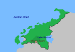
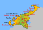
On the continent's north-west coast, on the Austral Strait, the landscape is characterised by rolling hills, mostly covered in forests. Off the west coast are larger and smaller islands, which provide calm waters. Further north, the coast is more affected by the rough winds coming from the Sea of Storms. The coastal plain slowly rises to eventually the Riponian Mountains, far east of the sultanate's land border.
This land border is interrupted by Lake Norton, the continent's largest inland water and therefore its main source of freshwater. Caves lead to vast underground cavern system known as the Corumian Underground. On the southern border, between Lake Norton and the Austral Strait, lies Mount Bijaro, named after Bijaro the Pallisican.
Climate
The northeast and southwest have a Mediterranean Climate, with a Desert Climate in between. In the far south, a Steppe Climate.
Time zone
The sultanate is classified in the time zone CMT+6. As a result, the far northeast is up to 30 minutes behind compared to Atos.
History
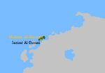
During the Second Çakari Era, which began in 1705 AN, the Çakar Empire grew by annexing The Green as well as through exchanging territory with other nations. In a treaty with the Imperial Federation, it obtained Jazirat Al-Borani, formerly known as Devil's Island. This was the beginning of Çakari presence on the continent.
However, before proceeding to annex parts of continental Corum, contact was sought with nearby nations. This led to a treaty with East Zimia and the Wallis Islands, which itself carried out an operation to annex Corum Electric.
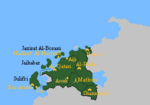
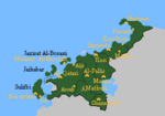
In 1722 AN, annexation of the area between the west coast to Lake Norton began. The southern border was laid across the top of Mount Bijaro, which left an area to New Batavia. Which annexed the area a year later. The incorporated territory was renamed a princely state, and the former grand vizier, Dervish Çelebi, was crowned sultan. The name ‘Jaihabar’ was introduced. The capital was moved to the new city of Mathura, located at the foot of Mount Bijaro. Finally, it was extended northwards along the northwest coast of the Austral Strait in 1726 AN.
-
1719 AN
-
1722 AN
-
1725 AN
Jaihabar Vortex
The Jaihabar Vortex began in 1737 AN, when shots were fired at protesters on the Agra Square in Mathura. Earlier that year, the first sultan had died and was succeeded by his son, Süleyman Çelebi. The latter insisted on announced tax increases, leading to all kinds of protests. When the protests escalated into violence, it spiralled into civil war. At the same time, the uprising of the Braxian League emerged, complicating the situation. At this, it was decided to leave Corum. After an agreement with the High King of the Caverns, the evacuation began.
Today, the Jaihabars mainly live in Korhalistan on the coast of the Azure Sea. In addition, another community in Agra in its own district.
List of rulers
The list of rulers since the transition of the state to a sultanate:
| No. | Portrait | Name | Reign |
|---|---|---|---|
| 1 | 
|
Dervish Çelebi | 1722 – 1737 AN |
| 2 | 
|
Süleyman Çelebi | 1737 - 1739 AN |
Timeline
- 11.XII.1719 AN: The Treaty between Çakaristan and Imperial Federation was signed.
- 1.I.1720 AN: Rouge is handed over to the Imperial Federation in exchange for Devil's Island.
- 7.IV.1721 AN: The Treaty between Çakaristan and East Zimia and the Wallis Islands was signed.
- 20.V.1722 AN:
- The Treaty between Çakaristan and New Batavia was signed.
- Jaihabar was created after expanding territory on Corum.
- 10.VI.1725 AN: Jaihabar was expanded northwards.
- 14.VII.1737 AN: Dervish Çelebi, sultan of Jaihabar and former grand vizier dies. His son succeeded him as sultan.
- 11.XI.1737 AN: The Agra Square incident takes place, taking the Jaihabar Vortex into a new phase.
- 15.XV.1737 AN: The evacuation complete, Corum was abandoned and Jaihabar dismantled. Devil's Island, previously known as Jazirat Al-Borani, was handed over to the Imperial Federation.
| ||||||||||||||||||||||||||||||||||||||||||||||||||||||||||||||||||

