Barikalus
| Barikalus إمارة باريكالوس | |||
| Riyasat of Çakaristan | |||
| |||
| Subdivision | Riyasat | ||
| Capital | Al-Hamra | ||
| Largest cities | Madinat al-Fath | ||
| Area | 2,368,368 km2 | ||
| Population | 67,608,328 census of 1740 | ||
| Nayib al'Amir | Farhan bin Alsalam | ||
| Legislature | |||
| Languages | Arboric | ||
| Time Zone | CMT+1:30 | ||
| Driving side | right | ||
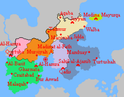
Barikalus, officially the Emirate of Barikalus (Arboric: إمارة باريكالوس), is a princely state of the Çakar Empire. Located in the north-east of the Empire, part of the continent of Apollonia. It forms the land borders with Lac Glacei to the north and Hurmu in the west, also maritime borders with Nouvelle Alexandrie. The coast is formed by the Antican Sea on the southwest, the Pond Strait on the southeast and Strait of Pearls on the east. The state surrounds the Khalij al-Salam (Arboric: خليج السلام) in which the capital is located. In the Strait of Pearls is the island of Mayurqa (Arboric: مايوركا) located.
The state was founded as a sovereign nation in 1685 as Emirate of Arbor on the continent of Keltia, which transformed after moving to Apollonia into the Emirate of Arbor in Barikalus. Between 1702 and 1704, the nation became a republic as a result of a coup d'état. The Arboric Civil War broke out and after international intervention, the nation was occupied by Çakaristan (initially as Great Apollonian Empire), Hurmu and Lac Glacei. Through the Dasil Agreement, parts of the territory were ceded and after a referendum, the remaining part was incorporated into the Çakar Empire.
Al-Hamra is the official capital and summer capital of the Çakar Empire. The administrative capital is Madinat al-Fath. The state is divided into seven taifas (provinces).
Name
The name "Barikalus" (Arboric: باريكالوس) means ‘land by the pond’, a reference to the nations location on the shore of Pond Strait. The earlier name "Arbor" was given to the original archipelago where the nation originated before the move. The name is Catologian for 'trees', referring to dense forestation on the islands. With the foundation of the Emirate that name was used for this new state. The name has been transliterated in the Arboric into 'arbur (أربور).
Geography

Water boundaries
Most of Barikalus' boundaries are water: the River Glacei, which forms the border with Hurmu from the Lac Glacei border, the Antican Sea along the west, the Strait of Monemici along the southwest, the Khalij al Salam, the Pond Strait along the southeast and Strait of Pearls along the east. The Dabab al-Sabah (morning mist bay) is part of the Strait of Pearls. The nation largest island, Mayurqa Island, is located in the same water.
Continental Peninsulas
The land mass of the nation can be roughly divided into two peninsulas, separated by the Khalij al Salam. The western peninsula is dominated by the Jibal al-Ahmar (Arboric: جبال الأحمر): the Red Mountains. Between these mountains and the River Glacei lies a watery lowland. There are many lakes and swamps, which are connected by a maze of streams and brooks.
From the mouth of the Glacei River in the Antican Sea to the Great Apollonian enclave of Vathia, lies a fertile coastal strip called: Qitae al-Bahr (Arboric: قطاع البحر): Sea strip. The southern coast along the Strait of Monemici is dominated by rocky cliffs and coves with sandy beaches.
Between the two peninsulas lies the Khalij al Salam, which is surrounded by a lowland. The coastline is jagged, but the landscape is slightly hilly. There are several islands in the gulf, including the island with the town of Al-Hamra. North of the gulf is the Maerifa Plain, which rises up to the northern border of the nation.
The eastern peninsula is dominated by the Jibal al-Hajar (Arboric: جبال الحجر): the Stone Mountains. The area between the mountains and the coast on the south and east sides is characterised by many streams and brooks, coming from the mountains and flowing into the sea. This area is called the Granary of Barikalus, because of its fertile land for agriculture. Further north, the landscape becomes dry and arid.
Mayurqa Island
The landscape of the island is characterised by woodlands, almond trees, fertile plains and often dramatic coastlines with sandy coves separated by craggy cliffs. The waters around the island contain many coral reefs.
History
- See also the Timeline of Arbor
Arbor Spring
In the disastrous year of 1685, the very young Franco-Batavian Empire shook its foundations. A plot to overthrow the Kaiser von Francia and King of Batavia was carried out. At the same time, the ancient High Realm of Stormark fell and disappeared from Micras. A power vacuum arose.
On the way to Batavian Cibola, Arkadius Frederik Gustavus of Vinandy was poisoned. A bottle of whiskey he received from a loyal friend contained poison. This put the Kaiser in a coma. Because the Imperial Frankish Guard had not checked this bottle, a power struggle arose with the Tassity Mansabdar. The plane with the Kaiser and his family was therefore flown to the Arbor Isles. That archipelago was a jarldom of Stormark, which had not long before been granted to the Kaiser.
The chaos was complete when communication with the outside world was cut off. The Frankish Empire became ungovernable because the Kaiser and the Regent were missing. The Chancellor was shot, the Amokolian Highlanders turned against the Franks. In Batavia it was still possible to keep the country together on the continent of Benacia. But Arcadia, Batavian Cibola and Helderbourgh ceased to exist.
The remaining loyal troops of the Tassity Mansabdar together with the loyal Imperial Frankish Army formed a new force: the Muharibu Alhuriya (Arboric: محاربو الحرية). To protect their Kaiser, the Arbor Isles were isolated and cut off from the outside world. This created a new state, which sees itself as the only legitimate successor to the Frankish Empire: the Emirate of Arbor. The comatose Kaiser was declared an emir. He was given the name: Mahmud bin Alsalam, meaning: the praiseworthy son of peace.
The news of the emirate's foundation became known all over Micras, causing the stateless and former Stormarkians to hope for a safe haven. The central person they hoped for is the emirate. Her Storish roots are obvious, but for the Normans felt connected to her because she was their Imperial Chieftain. Together with the Jorviks, the Normans organized an armada of ships to sail as many people as possible to the Arbor Isles. The local militia, consisting mainly of former soldiers, had gained control of all kinds of weaponry. Among them were ships, submarines, fighter jets, helicopters, tanks, etc. Weapons were also collected from other former Storish areas, only what was left behind was destroyed.
The rumours that an armada was on its way to Arbor were not believed. Too unlikely. But it turned out to be true. Hundreds of ships of all sizes sailed the Arbor Isles. When they arrived, they were received by the Emira herself. The refugees were grateful that they were allowed to come, but also declared that they would no longer appear in public as skyclad. Micras is too unsafe for such a free expression.
With the prospect of the Kaiseress becoming a stateholder, the fugitive community of Froyalaners was alarmed. Some young people wanted to take up arms in order to obtain freedom by force. But this was not strategically feasible and did not have the support of the entire community. The reports about the armada and its shelter in the Emirate gave hope. In a petition, the Froyalan community asked for support to leave for Arbor. The Grand Vizier announced that the refugees were welcome, after which he sent ships to the Corprian Archipelago to explore a residential area there.
That same day the Grand Vizier was told that an alien ship had arrived in the port of Jazirat 'Uwyastar. This ship brought representatives of the lost tribes of the Torosh and Souf. They came to plead for the favour of the Emir to include their homeland into the Emirate. An expeditionary corps was sent out to explore the tribes' land. In this way the borders were determined and the area was annexed by the Emirate. The area was referred to as al-Manatiq al-Gharbia (Arboric: المناطق الغربية): western territories. This expansion forced the isolation and access policy to be changed, because the strict policy could not be maintained.
On 3.VIII.1687 AN the Emir awoke from his coma. When the news of the coma became known, people celebrated all over the Emirate. The Emir is alive and awake!
Move to Apollonia
In 1694 AN the whole country moved to the continent of Apollonia. The vast majority of people have no memory of this. In a mysterious way, this transformation took place without hurting anyone or being worse. All buildings and houses moved with them undamaged, only their arrangement and location changed. The capital Al-Hamra was a medium-sized city, but today it is located on a small island off the coast in the Gulf of Peace. Access to the capital is still limited, while the rest of the country is open for visits.
Because there are still people with a memory of Keltian Arbor, there is a split in society. More and more people are calling for people with these memories to be labelled psychologically ill. Only the Emir and Emira also have memories of Keltian Arbor.
The border between the two countries has been agreed with the new northern neighbour. A treaty with that country is expected soon. By treaty Bur Astir (Port Esther) was transferred to Hurmu.
Arboric Civil War
On 20.X.1701 AN, the Arboric Civil War broke out after the incumbent Grand Vizier declared himself President, establishing a republic: the Arboric Republic of Barikalus. Five factions emerged, each pursuing its own goal and tearing the country apart. On 22.XI.1703 AN the Emir and Emira were executed.
Exactly 4 Norton years after the outbreak of the Civil War, it was ended on 20.X.1704 AN. The Arboric Republic of Barikalus and Farooqite Caliphate had been defeated. The country was divided into three occupation zones under Çakaristan (initially as Great Apollonian Empire), Hurmu and Lac Glacei.
Partition
During the occupation, the country became the State of Barikalus. Through the Dasil Agreement, it has been determined how the occupation will transition to a new future situation. This was changed somewhat with the outcome of the referendum, which incorporated Barikalus into the Çakar Empire.
Taifas
The taifas are the provinces within the emirate. The exact statehood of the taifas is unclear, as Barikalus does not formally have a constitution or state code. The word "taifa" (Arboric: طائفة) means "party", "band" or "faction".
| Flag | Taifa | Capital | Map | |
|---|---|---|---|---|
| Al Xarq الشرق |
Sahil al-Ajanib | 
| ||
| Arkish أركش |
Madinat al-Fath | |||
| Jafasu جافاسو |
Gharnata | |||
| Kahf Maqal كَهْف مَقَل |
Jayyan | |||
| Maerifa معرفة |
Qurtuba | |||
| Mayurqa مايورقا |
Medina Mayurqa | |||
| Tisinu تيسينو |
Qadis |
| ||||||||||||||||||||||||||||||||||||||||||||||||||||||||||||||||||


