Maps of Çakaristan: Difference between revisions
From MicrasWiki
Jump to navigationJump to search
No edit summary |
|||
| (22 intermediate revisions by the same user not shown) | |||
| Line 5: | Line 5: | ||
== Detailed maps == | == Detailed maps == | ||
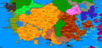
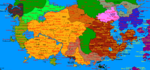
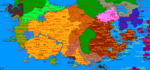
[[File:Cakaristan detailed map.png|1000px|thumb|left|The large detailed map (click to enlarge)]]{{clear|left}} | |||
[[File:Cakaristan detailed map | |||
=== Fragments === | === Fragments === | ||
| Line 14: | Line 12: | ||
<gallery widths="250" heights="250"> | <gallery widths="250" heights="250"> | ||
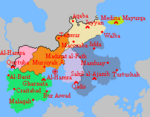
Image:Agra detailedmap.png|[[Agra]] | |||
Image:MapofCakariEastSkerries.png|Çakari East Skerries: [[Beneluccas]], [[Sanpantul]] and [[Sri Pashana]] | Image:MapofCakariEastSkerries.png|Çakari East Skerries: [[Beneluccas]], [[Sanpantul]] and [[Sri Pashana]] | ||
Image:Haritdesh detailed map.png|[[Haritdesh]] | |||
Image:Khordad Floods map.png|Map of the [[1728 Khordad Floods]], comprising [[Haritdesh]], Leyl and [[Sunehra]] | |||
Image:Kantisha and Nortak Islands detailedmap.png|[[Kantisha and Northak Islands]] | Image:Kantisha and Nortak Islands detailedmap.png|[[Kantisha and Northak Islands]] | ||
Image:Korhalistan detailledmap.png|[[Korhalistan]] | Image:Korhalistan detailledmap.png|[[Korhalistan]] | ||
Image:Leyl Sadarya detailedmap.png|[[Leyl Sadarya]] | |||
Image:Naudia'Diva detailed map.png|[[Naudia'Diva]] | |||
Image:Nuristan detailledmap.png|[[Nuristan]] | |||
Image:Poorajangal detailedmap.png|[[Poorajangal]] | Image:Poorajangal detailedmap.png|[[Poorajangal]] | ||
Image:Sylvania detailedmap.png|[[Sylfystan]] | Image:Suqutra detailedmap.png|[[Suqutra]] | ||
Image:Sylvania detailedmap.png|[[Sylfystan]] with [[Agra]] en [[Tiegang]] | |||
Image:Takaatui.png|[[Çakari Taka'atui|Taka'atui]] and [[Franklin Islands]] | |||
Image:Valesia detailedmap.png|[[Valesia]] | |||
</gallery> | |||
=== Legend === | |||
[[File:Guus detailedmap legend.png]]{{clear|left}} | |||
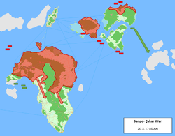
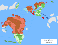
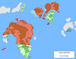
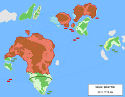
=== Maps of the [[Sanpo-Çakar War]] === | |||
<gallery widths="250" heights="250"> | |||
Image:SanpoCakarWar map01.png|Red: Spider fleet<br>Green: Green fleet | |||
Image:SanpoCakarWar map02.png | |||
Image:SanpoCakarWar map03.png | |||
Image:SanpoCakarWar map04.png | |||
Image:SanpoCakarWar map05.png | |||
Image:SanpoCakarWar map06.png | |||
Image:SanpoCakarWar map07.png | |||
Image:SanpoCakarWar map08.png | |||
</gallery> | </gallery> | ||
| Line 32: | Line 56: | ||
Image:MapofCakaridivisions.png|Map of the states | Image:MapofCakaridivisions.png|Map of the states | ||
Image:MapofCakaritimezones.png|Time zones in Çakaristan | Image:MapofCakaritimezones.png|Time zones in Çakaristan | ||
Image:MapofCakaristan MilitaryDistrics.png|Distribution of military districts | |||
Image:MapofCakaristanCamps1.png|Map of the internment camps | |||
</gallery> | |||
=== Further subdivisions === | |||
<gallery widths="150" heights="150"> | |||
Image:MapofArbor taifas.png|Subdivisions of [[Barikalus]] | |||
Image:Haritdesh Raajy.png|Subdivisions of [[Haritdesh]] | |||
Image:Korhalistan subahs.png|Subdivisions of [[Korhalistan]] | |||
Image:Sylfystan chaklas.png|Subdivisions of [[Sylfystan]] | |||
</gallery> | |||
=== Geographical maps === | |||
<gallery widths="150" heights="150"> | |||
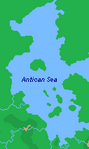
Image:AnticanSea physical.png|[[Antican Sea]] | |||
Image:Barax river.png|Barax river | |||
Image:Arbor geography.png|Geographical map of [[Barikalus]] | |||
Image:DyreStraitsphysical.png|[[Dyre Straits]] | |||
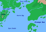
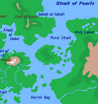
Image:HerrinBayphysical.png|[[Herrin Bay]] | |||
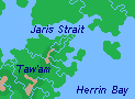
Image:JarisStrait physical.png|[[Jaris Strait]] | |||
Image:KendallIsle physical.png|[[Kendall|Kendall Isle]] | |||
Image:MapofLeylriver.png|[[Leyl River]] | |||
Image:PondStraitphysical.png|[[Pond Strait]] | |||
</gallery> | </gallery> | ||
| Line 54: | Line 103: | ||
Image:Cakaristan1711.png|Jaguda, Kyazilkai, Nuristan, Vashigol, West Pathaardesh and West Tartaristan | Image:Cakaristan1711.png|Jaguda, Kyazilkai, Nuristan, Vashigol, West Pathaardesh and West Tartaristan | ||
Image:Cakaristan1712.png|Kadim and Taka'atui | Image:Cakaristan1712.png|Kadim and Taka'atui | ||
Image:Cakaristan1717.png|Rouge, Wayfarer Atoll and Tarria | |||
Image:Cakaristan1718.png|Lija, West Sandwich Island and West Duras | |||
Image:Cakaristan1719.png|Jazirat Al-Borani | |||
Image:Cakaristan1722.png|Jaihabar | |||
Image:Cakaristan1725.png|Northeastern Jaihabar | |||
Image:Cakaristan1727.png|Jazirat Hintar | |||
Image:Cakaristan1740.png|Çexit: Leaving Corum, dismantling of Jaihabar | |||
Image:Cakaristan1745.png|Sanpantul independency | |||
Image:Cakaristan1745-2.png|Naudia'Diva | |||
</gallery> | </gallery> | ||
=== | === Maps of the [[Sylvanian National Awakening]] === | ||
<gallery widths="150" heights="150"> | <gallery widths="150" heights="150"> | ||
| Line 68: | Line 126: | ||
Image:Westernconsolidation map.png|Map of the Western consolidation | Image:Westernconsolidation map.png|Map of the Western consolidation | ||
</gallery> | </gallery> | ||
=== Maps of [[Operation: Nae jeevan kee raksha]] === | |||
<gallery widths="150" heights="150"> | |||
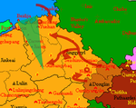
Image:Cakari invasion map.png|Green: Seishi triangle<br>Darkred: Çakari advance | |||
Image:Operation-Nea 1697.png|Start of the operation | |||
Image:Operation-Nea 1698 1.png|Northern wall | |||
Image:Operation-Nea 1698 2.png|Eastern wall | |||
</gallery> | |||
{{Çakaristan nav}} | {{Çakaristan nav}} | ||
[[Category:Maps]] | [[Category:Maps]] | ||
Latest revision as of 12:01, 5 July 2025
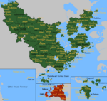
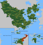
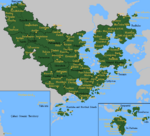
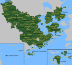
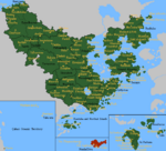
On this page all Maps of Çakaristan are collected.
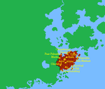
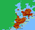
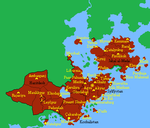
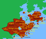
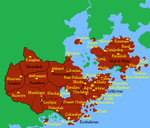
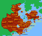
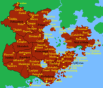
Detailed maps

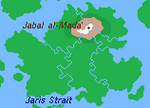
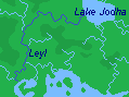
Fragments
The detailed maps are fragments from a large map, with which the plan is to map all of Çakaristan. In doing so, the plan is to keep developing the map as the nation develops.


Legend

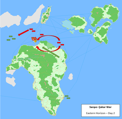
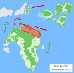
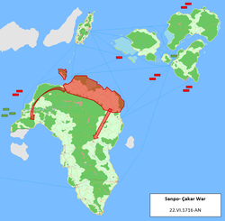
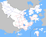
Maps of the Sanpo-Çakar War
-
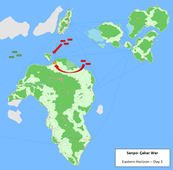 Red: Spider fleet
Green: Green fleet -
-
-
-
-
-
-


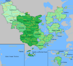
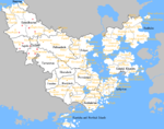
MCS styled maps
-
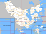
 Basic claimsmap
 -
 Climate map
 -
 Map of the driving side
 -
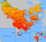
 Physical map of Çakaristan
 -
 Prime Meridian, antimeridian and Equator in Çakaristan
 -
 Map of railway lines
 -
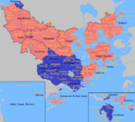
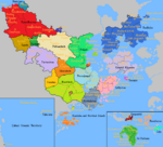 Map of the states
 -
 Time zones in Çakaristan
 -
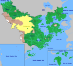
 Distribution of military districts
 -
 Map of the internment camps


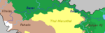
Further subdivisions
-
 Subdivisions of Barikalus
 -
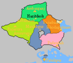 Subdivisions of Haritdesh
 -
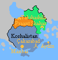 Subdivisions of Korhalistan
 -
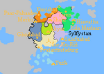 Subdivisions of Sylfystan


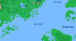
Geographical maps
-
-
 Barax river
 -
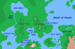 Geographical map of Barikalus
 -
-
-
-
-
-


Territory development
-
 1688 AN
 -
 1689 AN
 -
 1690 AN
 -
 1691 AN
 -
 1692 AN
 -
 1693 AN
 -
 1694 AN
 -
 1695 AN


-
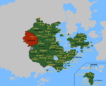 Sunehra and Tartaristan
 -
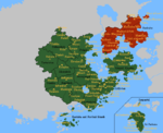
 Kantisha and Northak Islands
 -
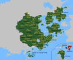
 Barikalus
 -
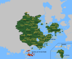
 Beneluccas
 -
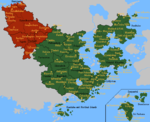 Jaguda, Kyazilkai, Nuristan, Vashigol, West Pathaardesh and West Tartaristan
 -
 Kadim and Taka'atui
 -
 Rouge, Wayfarer Atoll and Tarria
 -
 Lija, West Sandwich Island and West Duras
 -
 Jazirat Al-Borani
 -
 Jaihabar
 -
 Northeastern Jaihabar
 -
 Jazirat Hintar
 -
 Çexit: Leaving Corum, dismantling of Jaihabar
 -
 Sanpantul independency
 -
 Naudia'Diva


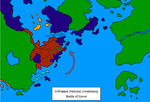
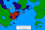
Maps of the Sylvanian National Awakening
-
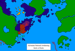 Map of the Battle of Shahr
 -
 Map of the Battle of Merku
 -
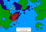 Map of the Run to the coast
 -
 Map of the Battle of Gevet
 -
 Map of Foot on the Ground
 -
 Map of the Soft Underbelly
 -
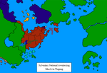 Map of the March to Tiegang
 -
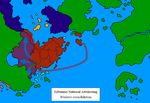 Map of the Western consolidation


Maps of Operation: Nae jeevan kee raksha
-
 Green: Seishi triangle
Darkred: Çakari advance -
 Start of the operation
 -
 Northern wall
 -
 Eastern wall


| ||||||||||||||||||||||||||||||||||||||||||||||||||||||||||||||||||
