Eastern Amarra
| Cisamarra – Eastern Amarra – Eastern Sanilla | |
| PЬумәқe AмapЬa Еса Province of Eastern Amarra | |
| Capital | Pixa |
| Largest cities | Xeriffa, Kerhula, Mentira, Gardenholm, Kopore |
|
| |
| Population | |
|
10,082,354 (1680) |
|
58.17 per km2 |
|
4 of 9 |
| Area | 173,317 km2 |
|
2 of 9 |
|
| |
| Government | |
|
Supreme Council (11) |
|
Supreme Congress (235) |
|
| |
| National representation | |
| 69 MLs | |
|
| |
| Language(s) | |
|
Sanaman |
|
Istvanistani, Passikaans, Cisamarrese, Babkhi |
| Local religion | Somanes, Cedrism, Nazarenism, others, irreligious |
| Code | EAM |
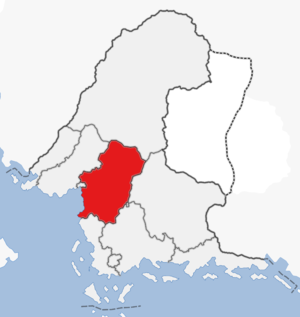
The Province of Eastern Amarra was a province in central Sanama. The province had a population of over nine million people and an area of 173,000 km2, making it the fourth most populated and second largest province. The province was formed in 1679 with the passage of the new federal constitution and was largely coterminous with the previous Eastern Amarra region. The province was dominated by forests interspersed with farmland, mostly banana and rice plantations, with highlands in the north and plains in the south, with the northern highlands covered in large oil fields. It was bordered to the southwest by Fatehpur Sikri and the Cosimo Sea, to the west by Western Amarra, to the north by Highpass, to the east by Thanatos and the Federal Capital Territory, to the southeast by Central Sanilla and to the south by Western Sanilla. The capital Pixa is located on the coast in the southwest.
Geography
The southern parts of the province is made up of tropical forest interspersed with farmland. The center of the province has several smaller lakes and a humid climate, while the northern highlands have massive temperate forests between large oil fields. The forests are home to many species of animals and birds. Most people live in the southern and western parts of the province, while the east and north are more sparsely populated. The border with Thanatos to the east runs along the Dead River that gets its name from the frequent leaks of lava into its stream, usually killing hundreds of fish that then drift down the river.
Economy
Eastern Amarra is a rural and forested province, with farms and forestry industry in the south. The farms in the south usually grow banana and rice, but also citrus fruit, coconut and cocoa beans. In the forested east there are several small mines, mostly for iron and copper. The largest private employer in the southern half of the province is Tanisha Foods that run several farms in the area. The north is completely dominated by the SanOil oil fields, which are centered on the city of Gardenholm. The federal government is also a large employer in the province, with the 6th Army Division in Gardenholm and the 7th Army Division in Hall in the south. The urban areas in the west close to Fatehpur Sikri are seeing a boom in industry and many new companies established.
Politics
Eastern Amarra is governed by an eleven-member Supreme Council elected by the 235-member Supreme Congress. Both bodies serve three-year terms. The Supreme Council is headed by the Minister-President, who acts as head of government. Since the election of 1679 the provincial government has been run by a coalition of the Sanaman Liberation Front, Coalition 1660 and the Green Alliance. The main opposition is the United Nationalist Alliance. Just like in most other governments in Sanama, the province is heavily affected by civil service corruption and inefficiency.
| |||||||||||||||||||||||


