Central Sanilla
| Western Sanilla – Central Sanilla – Cisamarra | |
| Rrumëqe Sanilla Senterale Province of Central Sanilla | |
| Capital | Kawite City |
| Largest cities | Pakuwi, Hala City, Qerunor, Timpure |
|
| |
| Population | |
|
9,763,172 (1680) |
|
61.32 per km2 |
|
6 of 9 |
| Area | 159,212 km2 |
|
6 of 9 |
|
| |
| Government | |
|
Executive Council (11) |
|
Legislative Council (215) |
|
| |
| National representation | |
| 66 MLs | |
|
| |
| Language(s) | |
|
Sanaman |
|
Istvanistani, Yardistani |
| Local religion | Somanes, Cedrism, others, irreligious |
| Code | CSA |
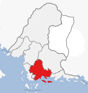
The Province of Central Sanilla is a province in southern Sanama. The province has a population of almost nine million people and an area of 159,000 km2, making it the sixth most populated and sixth largest province. The province was formed in 1679 with the passage of the new federal constitution and is largely coterminous with the previous Central Sanilla region. The western and southern parts of the province are dominated by agriculture, mostly ricefields, banana and coconut plantations, as well as grazing lands. The Santa Clara islands to the south belong to the province and are a growing tourist destination as well as a large supplier of sugar cane, corn and pineapple. The province is bordered to the west by Western Sanilla and Niyi, to the north by Eastern Amarra and the Federal Capital Territory, to the northeast by Thanatos, to the east by Eastern Sanilla, and to the south by the Gulf of Khaz. The capital Kawite City is located in the eastern part of the province and is a major port for import and export of foodstuffs.
| |||||||||||||||||||||||


