User:Mondo/Things: Difference between revisions
| Line 516: | Line 516: | ||
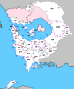
==Cibola 1716== | ==Cibola 1716== | ||
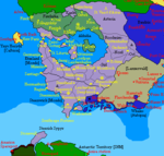
[[File: | [[File:MDO Claim Map 1716.png|left|150px|thumb]] | ||
Revision as of 16:27, 9 January 2023
| Empire of Etzeland Kaisertum Etzeland | |||
| |||
| Motto: Mondo Macht Mondosachen (English: Mondo does Mondo things) | |||
| Anthem: "Das Mondolied" | |||
| |||
| Map versions | 17.4.6 - | ||
| Capital | Neurossheim | ||
| Largest city | Helderburg | ||
| Official language(s) | Istvanistani Cibolan Saxon Akhidian Tiěyán | ||
| Official religion(s) | Mondo Personality Cult Nidarosian Nazarene | ||
| Demonym | Etzer, Etzerlander | ||
| - Adjective | Etzish | ||
| Government | Federal semi-constitutional monarchy | ||
| - Kaiser | Mondo | ||
| - State Leader | Helmut Drosselmeyer | ||
| - Legislature | - | ||
| Establishment | 10.III.1702 AN | ||
| Area | 3,893,556 sq.km | ||
| Population | 13,535,551 | ||
| Active population | 1 | ||
| Currency | Mondomark | ||
| Calendar | |||
| Time zone(s) | CMT-10, CMT -11 | ||
| Mains electricity | |||
| Driving side | right | ||
| Track gauge | |||
| National website | - | ||
| National forum | - | ||
| National animal | Siebenbergen Goat | ||
| National food | Etzetorte | ||
| National drink | - | ||
| National tree | - | ||
| Abbreviation | ETZ | ||
Etzeland, officially the Empire of Etzeland (Cibolan Saxon: Kaisertum Etzeland), is a sovereign monarchy in southern Cibola. It was established on 10.III.1702 AN by Cibolan Saxon forces loyal to Mondo Etzeterra.
Prior to 21.IX.1702 AN, it was known as the Mondostate of Etzeland (Cibolan Saxon: Mondostaat Etzeland), between 21.IX.1702 and 12.XIII.1702 AN as the Duchy of Etzeland (Cibolan Saxon: Herzogtum Etzeland), and from 12.XIII.1702 AN until the proclamation of the empire on x.x.1706 AN as the Grand Duchy of Etzeland (Cibolan Saxon: Grossherzogtum Etzeland).
Etymology
The term Etzeland is a partial calque of the surname Etzeterra. Originally from Shireroth, the Etzeterras were a prominent local noble family in Woodshire County before moving to Minarboria.
History
Prehistory
Prior to the opening of Cibola in the 15th century AN, the southern half of the continent was dominated by various proto-Germanic speaking peoples, of which comparatively little is known.
First states
By the 1490s, the various Germanic-speaking peoples had coalesced into a centralised state, Germania, which came to dominate southern Cibola. It was during this period that the first continuously-inhabited cities began to emerge, including Hanover (present day Leichenberg), founded 1490-1500 AN, and Stuttgart (present day Neurossheim), founded c.1503 AN Around 1503 AN, Germania briefly expanded to include the first Principality of Treisenberg, however the union was of short duration and precipitated the final fall of the Germanian state by 1505 AN.
By 1516 AN, the emerging French-speaking Kingdom of Monovia had expanded into eastern Germania, occupying the capital, Berlin, and the city of Stuttgart. Over the course of the following five years, Monovia successfully incorporated most of the former Germanian lands, but the resulting overreach contributed to the collapse of central royal authority c.1527 AN.
A revived Germanian state emerged around 1541 AN. and swiftly dominated the region, before disintegrating into petty states only seven years later.
Rossheim era
In 1592 AN., the Rossheimers, an ancient Treisenberger noble family ruling the Corumese Kingdom of Sangun, established themselves in the area, re-founding the city of Hanover as the capital of the eponymous Duchy of Rossheim-Leichenberg. Rossheim-Leichenberg subsequently merged with another Rossheimer principality, Rossheim-Volksburg, to form the Duchy of Rossheim, which itself became a constituent state of a revived United Principalities of Treisenberg. Four years later, the Duchy of Rossheim was proclaimed the Kingdom of Leichenberg, with the United Principalities reconstituted as the abortive Cibolan Confederation.
Upon inheriting the Sangunese throne, in 1600 AN the King of Leichenberg combined his two realms into Sangun-Leichenberg, which eventually evolved into the Empire of Sangun and South Cibola. Weakened by a series of dynastic squabbles among the various members of the ruling Rossheim dynasty, the struggling empire was incorporated within the Empire of Minarboria in 1635 AN.
Fall of Minarboria, Treisenberg revival and Helderbourgh
Following the disintegration of Minarboria between 1640 and 1644 AN, the power vacuum in southern Cibola was swiftly filled by a third Treisenberg State. Wracked by civil war in the aftermath of the 1660 White Plague, Treisenberg was succeeded in 1667 AN by the newly-established Grand Duchy of Helderbourgh, which ruled the region until 1685 AN, initially as independent state, but from 1672-3 as an autonomous region of Batavia.
Establishment of Etzeland
In early 1702 AN, a descendent of the Rossheimers, Mondo Etzeterra, announced a claim to six former Leichenberger bailiwicks. Following a brief conflict between pro- and anti-Mondoist forces, the former eventually prevailed, subsequently proclaiming the establishment of the Mondostate of Etzeland on 10.III.1702.
On 21.IX.1702, the country was officially renamed the Duchy of Etzeland (Cibolan Saxon: Herzogtum Etzeland). Less than four months later, on 12.XIII.1702 AN the Drosselmeyer administration declared Etzeland a grand duchy, apparently in response to the adoption of the superior style by Steerswick.
Expansion
After lengthy negotiations, the cities of Helderburg, Kronstadt and Vaduz acceded to Etzeland on the first day of 1703 AN, with the latter two changing their names to Mondostadt and Monduz respectively. In 1706 AN, Canton Leichenhafen annexed an area of 2,232 square kilometres in the north east, while Canton Monduz was expanded by 5,256 square kilometres. A further 67,140 square kilometres of former Tieyan territory was occupied as the Eisenfels Natitional Park (Cibolan Saxon: Naturpark Eisenfels); this area was ceded to South Akhidia the following year in exchange for 19,224 square kilometres of territory surrounding the ancient city of Alttreisen, which was incorporated as a seventh canton, Treisenberg. Mondo's personal Duchy of Rossheim was also incorporated within Etzeland later that year.
The proclamation of the Mondo Line in XII.1709 AN marked the beginning of a further phase of expansion. In XIII.1709 AN, Etzeland and Steerswick mounted a joint operation to occupy the Highfields region bordering Whales and Lanzerwald; the occupied territories were later divided between the two countries, with Etzeland receiving an area of 163,200 square kilometres. Canton Leichenberg subsequently annexed 180 square kilometres, while the remainder was formerly incorporated as the eighth canton of Hochfelden in II.1716 AN. The following month, a further 1,117,260 square kilometres lying to the north of Rossheim that had been claimed by Mondo in 1709 AN were incorporated as a second autonomous duchy, Artesia.
Union with South Akhidia and establishment of the empire
On x.x.1716 AN, King Şahan I of South Akhidia abdicated in favour of his stepmother Anastasia, in order to contest the throne of his ancestral kingdom of East Akhidia. The South Akhidian Ahidar (legislature) subsequently voted in favour of union with Etzeland, and the majority of South Akhidia was incorporated within the newly-proclaimed Empire of Etzeland on x.x.1716 AN, with the exception of the province of Dunaria, which was annexed by Steerswick.
Geography
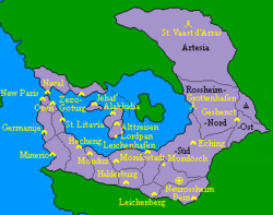
Etzeland is situated in southern Cibola, surrounding the Central Sea (Batavian: Zeetuinen, Germanian: Meergarten). Its original territory consisted of a series of river basins extending northwards from the central Helderberg and Leichenberg ranges, whose peaks mark the southern border of the country, but has since expanded to include the Barbary peninsula and other territories to the west of the continental watershed.
The land along the coast is relatively flat and low lying, particularly in the west, but the terrain becomes increasingly mountainous inland. The highest elevation in the country is the summit of Leichenspitze (Lich Peak), to the west of the city of Leichenberg.
Etzeland has several major rivers. The longest is the Oesch, which occupies the easternmost valley system; the river itself divides into the Vorderoesch and Hinteroesch at the city of Mondoesch.
The northern half of the country has a warm-summer Mediterranean climate (Csb), whereas the south has a predominantly hemiboreal continental climate (Dfb).
Demographics
Ethnic groups in Etzerland
Etzeland has a total population of 13,535,551. Population growth is low but consistent, due to a combination of immigration from other Mondosphere countries and a fertility rate slightly above replacement level. The population is highly urbanised and enjoys a high quality of life, with a life expectancy at birth of over 80.
Etzish nationals account for 91.2% of the population, a majority of whom (50.4%) are of Cibolan Saxon ethnicity. Other significant ethno-linguistic groups include Tiěyáns (10.1 %), Batii (9.3%), Bretallois (7.8%), Batavians (7.6%), Fentoians (4.3%), and Steerish and Dunarians (1.7%). Resident foreign nationals constitute some 8.8% of the population, the majority of which are from other Mondosphere countries.
Nationality
Citizenship is granted and recorded at the cantonal level and all Etzish nationals are citizens of a particular canton of origin (Cibolan Saxon: Heimatkanton), which is not necessary the same as their canton of birth or current residence. Naturalised foreigners are also assigned a canton of origin.
Language
Cibolan Saxon is the principal national language of Etzeland and is used as a first language by just over 50% of the population. Istvanistani, Tiěyán, Bretallois, Batavian and Akhidian are also widely spoken.
Religion
Religious adherence in Etzerland
According to recent figures, 73% of the population have a professed faith, the majority of which are Nazarenes. Nazarene Catholics make up 48.6% of the population and since 1702 AN, the community has been in full communion with the Church of Nidaros. Nazarene Orthodox and Protestants account for a further 13.5 % and 3% of the population respectively. Tieyan traditional beliefs are practiced by 5.9% and Umraism by 0.8%. The remaining 1.2% are adherents of other recognised religions.
Government and Politics
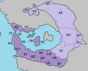
Etzeland is a federal semi-constitutional monarchy comprised of eighteen self-governing cantons and two autonomous duchies.
Monarchy
Sovereignty and supreme executive authority is vested in the reigning monarch, Mondo Etzeterra, who has the title of Kaiser of Etzeland. Although the monarchy is notionally hereditary, in view of the grand duke’s nature as a lich, the succession to the imperial throne is considered a largely theoretical matter. However, there is provision for the heir to the throne, Crown Princess Lystasia, to act as temporary monarch should her father be incapacitated.
In the Kaiser’s absence, day-to-day executive authority is exercised on his behalf by the State Leader (Cibolan Saxon: Staatsleiter). The current State Leader is the head of the pre-eminent Mondo Party (Cibolan Saxon: Mondopartei), Helmut Drosselmeyer.
Federal Advisory Council
The Kaiser and State Leader are advised by the Federal Advisory Council (Cibolan Saxon: Bundesbeirat), which consists of the Kaiser, the State Leader, two elected representatives from each of the eighteen cantons and the Duchy of Artesia, and two appointed representatives from each of the three shires of the Duchy Rossheim. The council assists in the formulation of state policy and appoints federal ministers, subject to the Kaiser’s approval.
Cantons
The eighteen cantons (Cibolan Saxon: Kanton; plural Kantone) are federated states with a high degree of autonomy. Each canton has its own government, police and courts and has the power to set local, but not federal, taxation. The cantons also contribute a portion of their own revenue towards the costs of the federal government.
| Flag | Canton | Code | Canton since | Capital | Area (sq km) | Population | Bailiwicks |
|---|---|---|---|---|---|---|---|
| East Bretalyon | EB | 1716 | St. Litavia | 49,320 | 619,500 | - | |
| East Tieya | ET | 1716 | Hecheng | 180,468 | 586,700 | - | |
| Helderburg | HB | 1703 | Helderburg | 95,328 | 1,125,559 | - | |
| - | Hochfelden | HF | 1716 | Bein | 163,020 | 200,096 | - |
| Jehaf | JE | 1716 | Jehaf | 21,744 | 119,200 | - | |
| - | Leichenberg | LB | 1702 | Leichenberg | 51,114 | 377,282 | - |
| - | Leichenhafen | LH | 1702 | Leichenhafen | 111,312 | 1,046,468 | 3 |
| - | Mondostadt | MS | 1703 | Mondostadt | 133,440 | 1,845,229 | 3 |
| - | Monduz | MZ | 1703 | Monduz | 150,960 | 694,072 | 2 |
| - | Neurossheim | NR | 1702 | Neurossheim | 128,760 | 926,266 | 2 |
| North Barbary | NB | 1716 | Naval | 123,084 | 741,500 | - | |
| Ortada | OR | 1716 | Alakhidia | 46,548 | 162,700 | - | |
| South Barbary | SB | 1716 | Oren | 19,476 | 454,000 | - | |
| Suro | SU | 1716 | New Paris | 14,940 | 1,167,300 | - | |
| Treisenberg | TR | 1707 | Alttreisen | 42,948 | 476,355 | 2 | |
| West Bretalyon | WB | 1716 | Germanije | 82,224 | 585,900 | - | |
| West Tieya | WT | 1716 | Minerio | 122,832 | 434,000 | - | |
| Zezo-Goturg | ZG | 1716 | Zezo-Goturg | 61,740 | 185,000 | - | |
| Etzeland[1] | ETZ | - | Neurossheim | 1,599,288 | 11,746,927 | 12 |
Five of the cantons are further subdivided into bailiwicks (Cibolan Saxon: Vogtei): Canton Leichenhafen into Leichenhafen, Neumarkt and Oberwald Bailiwicks; Canton Mondostadt into Bärental, Krählen and Mondostadt Bailiwicks; Canton Monduz into Monduz and Waldenburg Bailiwicks; Canton Neurossheim into Neurossheim and Mondoesch Bailiwicks; and Canton Treisenberg into Alttreisen and Lordpan Bailiwicks.
Autonomous Duchies
In addition to the eight cantons, Etzeland includes two autonomous duchies with separate administrative structures and distinct legal statuses: Rossheim and Artesia.
The Duchy of Rossheim (Cibolan Saxon: Herzogtum Rossheim), also known as Altrossheim (Old Rossheim), is the personal demesne of Mondo, who owns the overwhelming majority of the land as private property. Legally, the duchy has no native population besides Mondo. Etzish citizens enjoy limited rights to residency and property ownership (usually in the form of long-term leases rather than freehold) in designated areas, but remain citizens of their canton of origin; those Etzers born in the duchy are similarly considered citizens of their parents’ canton. All revenue from the duchy beyond that required for the local administration goes to support Mondo and his work, although he voluntarily remits a certain proportion to Etzeland’s federal government.
The duchy is subdivided into three shires (Cibolan Saxon: Gau; plural Gaue) and one national park (Cibolan Saxon: Naturpark):
| Shire | Code | Administrative HQ | Area (sq km) | Population[2] |
|---|---|---|---|---|
| Rossheim-Nord | RN | Grottenhafen | 490,764 | 181,216 |
| Rossheim-Ost | RO | Geshenct | 124,128 | 49,348 |
| Rossheim-Süd | RS | Eching | 482,988 | 92,782 |
| Naturpark Rossheim | RP | - | 79,128 | - |
| Rossheim | RHM | Grottenhafen | 1,177,008 | 323,346 |
Established in III.1716 AN, the Duchy of Artesia (Cibolan Saxon: Herzogtum Artesien; Alexandrian: Duché d'Artois), is a historically Alexandrophone region centred on the city of St Vaast d'Arras (Cibolan Saxon: Sankt Vedast im Artesien; historic Alexandrian: Arras).
| Region | Code | Administrative HQ | Area (sq km) | Population |
|---|---|---|---|---|
| Artesia | AR | St Vaast d'Arras | 1,117,260 | 1,465,278 |
Foreign Relations
Etzeland is a leading member of the Mondosphere. An informal alignment of independent states owing allegiance to Mondo, the Mondosphere has never been established by treaty and operates largely at the whim of its enigmatic head. While there are no legal restrictions preventing a member state from concluding its own diplomatic agreements, in practice Etzeland's foreign policy continues to be heavily influenced by the decisions of Fort Ermingander.
Military
Etzeland's armed forces are known as the Heimwehr Etzeland (Etzeland Home Guard). The Heimwehr Etzeland was established in early 1702 with the amalgamation of the various local militias, and was originally of brigade strength, consisting of five battalions:
- Sturmbataillon Etzeichen, a volunteer mechanised battalion at Neurossheim;
- 1. Infanterie Bataillon, a militia infantry battalion at Neurossheim;
- 2. Gebirgs Bataillon, a militia mountain infantry battalion at Leichenberg;
- 3. Infanterie Bataillon, a second militia infantry battalion at Leichenhafen;
- Military Training Centre at Mondoesch.
The Heimwehr expanded considerably over the following eighteen months, and as of I.1704 AN has a strength in excess of 30,000 personnel. Its active strength consists of six territorial brigades, divided equally between two division-level regional commands responsible for the eastern and western halves of the country. An additional mechanised brigade formed around the Sturmbataillon Etzeichen is retained as a reaction force under the direct control of the high command.
The Heimwehr's commander is Korpskommandant Sylvester Schlumpf.
Rossheim Dragoon Guards
A historic household cavalry regiment of the Leichenbergish Army, the Rossheim Dragoon Guards, was reformed on 11.XIII.1702 AN. The regiment is not part of the Heimwehr Etzeland and remains under the personal command of Mondo.
Economy
Etzeland has a strong industrialised economy, having inherited the bulk of Helderbourgh's mining and manufacturing sector. The state is a major producer of gold and other metals, with several large mines in the south of the country. The valleys and coastal regions in the north support intensive agriculture, sufficient to support the local population. Manufacturing is concentrated principally in and around the cities of Neurossheim, Leichenhafen and Mondostadt.
The three largest corporations are Etzische Mondowerke (heavy industry, shipbuilding, vehicles and aerospace), Cibo-Monduz (pharmaceuticals and chemicals), and Etzische Bankverein (financial services).
Education
Infrastructure
Etzeland possesses a modern transportation network within its core territories in the south and west. The city of New Paris is served by two airports, Suro King Zezo and Domansk, while most other major cities possess a single hub for local and domestic and international flights. The cities of the Barbary Peninsula and Etzish heartlands are linked by road and rail networks that also connect to neighbouring states, most notably Steerswick. A state-owned ferry service connects the two sides of the Barbary Strait and links the various islands of the Inner Sea to the mainland and each other.
Culture
Media
Sports
Football is a popular sport in Etzeland. The country possesses several top-flight teams, divided between the Etzeland-Steerswick Football League and a united Akhidian league, the Liga Ahidya. As of 1716 AN, various plans are being studied to unite the country's football structure. Internationally, Etzeland is represented by a national football squad as well as the unified Akhidian international team.
Rugby, volleyball, baseball, basketball and archery are also popular and the subject of regular domestic competitions.
Cuisine
Etzeland's cuisine is a fusion of elements inherited from the various ethnic groups who inhabit the empire. Various cheese-based dishes are popular in the Etzish heartlands of the south, while Shella, a seafood wrap made with shrimp, peppers and garlic and served with potatoes dipped in sunflower oil, is the signature dish of the former Akhidian lands in the northwest. Tieyan food is also increasingly popular outside its traditional homeland.
Thanks to the influence of the Kaiser, cake is widely consumed.
stuff
| Item | HQ & HQ Squadron | Sabre Squadron | Artillery Battery | Regiment |
|---|---|---|---|---|
| Lieutenant Colonel (LTC) | 1 | - | - | 1 |
| Major (MAJ) | 2 | 1 | - | 5 |
| Captain (CPT) | 8 | 1 | 1 | 12 |
| Lieutenant (LT) | 4 | 4 | 3 | 19 |
| Commissioned Officers | 15 | 6 | 4 | 37 |
| Regimental Corporal Major (RCM) | 1 | - | - | 1 |
| Corporal Major (CPM) | 3 | 1 | 1 | 7 |
| Staff Corporal (SCP) | 9 | 5 | 2 | 26 |
| Chief Corporal (CCP) | 12 | 14 | 6 | 60 |
| Corporal (CPL) | 19 | 22 | 9 | 94 |
| Lichguard (LGD) | 16 | 24 | 4 | 92 |
| Non-commissioned Officers | 60 | 66 | 22 | 280 |
| Zombot (ZBT) | 55 | 22 | 29 | 150 |
| Total Personnel | 130 | 94 | 55 | 467 |
| Item | HQ & HQ Squadron | Sabre Squadron | Artillery Battery | Regiment |
|---|---|---|---|---|
| Necrogravimetric Vehicle Combat Tank 120mm | 1 | 9 | - | 28 |
| Necrogravimetric Vehicle Combat Infantry 40mm | 1 | 9 | - | 28 |
| Necrogravimetric Vehicle Combat Howitzer 155mm | - | - | 3 | 28 |
| Combat vehicles | 2 | 18 | 3 | 59 |
| Necrogravimetric Vehicle Carrier Cargo | 37 | 3 | 15 | 61 |
| Necrogravimetric Vehicle Carrier Command | 4 | 1 | 1 | 8 |
| Necrogravimetric Vehicle Carrier Necromedical | 5 | - | - | 5 |
| Support vehicles | 46 | 4 | 16 | 74 |
| Machine Gun 12.7mm | 17 | 2 | 6 | 29 |
| Crew-served weapons | 17 | 2 | 6 | 29 |
| Launcher Grenade | - | 8 | - | 24 |
| Machine Gun 5.56mm | - | 8 | - | 24 |
| Pistol 9mm | 11 | 45 | 12 | 158 |
| Rifle 5.56mm Carbine | 106 | 46 | 43 | 287 |
| Small arms | 117 | 107 | 55 | 493 |
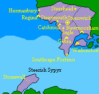
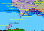
Steerswick
Administrative Divisions
| Province | Administrative Centre | Code | Area (sq km) | Population | Established |
|---|---|---|---|---|---|
| East Steeria | Steerswick City | ES | 193,968 | 658,852 | 1702 |
| Isle of Wadon/Enys Wadon | Wadonston | WD | 40,104 | 378,508 | 1708 |
| Southcape/Penn an Soth | Gebra | SC | 244,872 | 369,578 | 1706 |
| Southmoorland | Newmoorham | SM | 278,244 | 141,538 | 1708 |
| West Steeria | Regina | WS | 195,084 | 444,985 | 1707 |
| Steerish Sypyr | - | SY | 109,368 | - | 1708 |
| Steerswick | Steerswick City | STW | 1,061,640 | 1,993,461 | 1702 |
Cibola 1709
| Central Cibolan Empire Zentralsiebenberge Reich 中七山帝國 Zhōng Qīshān Dìguó | |||
| |||
| Motto: | |||
| Anthem: | |||
| [[|250px|Location of |frameless]] | |||
| Map versions | |||
| Capital | Neurossheim | ||
| Largest city | New Paris | ||
| Official language(s) | Istvanistani Cibolan Saxon Akhidian Tiěyán | ||
| Official religion(s) | Mondo Personality Cult Nidarosian Nazarene | ||
| Demonym | Cibolan | ||
| - Adjective | Cibolan | ||
| Government | Federal semi-constitutional monarchy | ||
| - Kaiser | Mondo Etzeterra | ||
| - Crown Princess | Lystasia Steerswick | ||
| - Legislature | - | ||
| Establishment | 1708 AN | ||
| Area | 2,763,912 sq.km | ||
| Population | 12,425,177 | ||
| Currency | Mondomark | ||
| Calendar | |||
| Time zone(s) | CMT-10 CMT-11 | ||
| Mains electricity | |||
| Driving side | right | ||
| Track gauge | |||
| National website | - | ||
| National forum | - | ||
| National animal | Siebenbergen Goat | ||
| National food | Kaisertorte | ||
| National drink | - | ||
| National tree | - | ||
| Abbreviation | CIB | ||
The Cibolan Empire is a federation of four states- the Grand Duchy of Etzeland, the Grand Duchy of Steerswick, the Kingdom of South Akhidia, and the Barony of Blue Kaek and Zijincheng- under the permanent presidency of the Grand Duke of Etzeland, who has the aditional title of Cibolan Emperor (Siebenberge Kaiser). The vice-presidency is vested in the Grand Duchess of Steerswick as Crown Princess.
The Imperial Government is responsible for foreign policy, common economic policy and military affairs. Steerswick retains the right to maintain a separate military and diplomatic service.
Citizenship is granted and regulated by the individual states.
Imperial Council:
Emperor (as President) Crown Princess (as Vice President) & 21 representatives: 9 Etzeland 8 South Akhidia
Steerswick Football Squad
- Jack Trelawney (Capt) (Steerswick City FC)
- Mike Penkivel (Steerswick City FC)
- Jason Gummow (Gebra FC)
- Bradley Kessel (Gebra FC)
- Stephen Fowey (Steermouth FC)
- Udney Wade (Steerswick City FC)
- Jago Hellier (Steerswick City FC)
- Judd Mawgan (Steerswick City FC)
- Rich Burnett (Steerswick City FC)
- Johnny Tremarton (Steermouth FC)
- Alan Crantock (Steermouth FC)
- Julian Clemo (Gebra FC)
- Andreas Hofer (Steerhead FC)
- Simon Perez (Regina FC)
- Diego Madron (Regina FC)
- Harry Harmel
- George Stratton (Wadonston FC)
- Billy Bude (Steerswick City FC)
- Tom Ventongimps (Steermouth FC)
- Martin Strudel (Steerhead FC)
- Clovis Clotworthy (Steermouth FC)
(2 left)
Riskai Football Squad
Goalkeepers 23. Olaf STURLUSON Hendrik Thoraldson
Defenders 3. Baldur EINARSSON 13. Hjalmar HELGASON 20. Magnus MARTEINSSON
Midfielders 14. Helgi GUNNARSSON 21. Harald RURIKSON
Fowards 11. Arnar TORFASON 16. Arnkel THORDARSON 22. Jón PETURSSON 9. Karl-Jacob STRELLER


