Port Elerat: Difference between revisions
No edit summary |
mNo edit summary |
||
| Line 6: | Line 6: | ||
|imagesize = | |imagesize = | ||
|image_caption = | |image_caption = | ||
|image_flag = Eleratflag.png | |image_flag = Eleratflag.png | ||
|image_seal = | |image_seal = | ||
|nickname = | |nickname = | ||
|motto = | |motto = | ||
|image_map = PIsherwood_in_Gerenia.png | |image_map = PIsherwood_in_Gerenia.png | ||
|mapsize = | |mapsize = 250px | ||
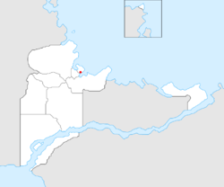
|map_caption = Location within [[Mainland Gerenia]] | |map_caption = Location within [[Mainland Gerenia]] | ||
|subdivision_type = Nation | |subdivision_type = Nation | ||
| Line 25: | Line 25: | ||
|leader_name = | |leader_name = | ||
|elevation_m = | |elevation_m = | ||
|population_as_of = | |population_as_of = 2018 | ||
|population_total = 1, | |population_total = 1,126,512 | ||
|population_rank = [[List of cities and towns in Gerenia|1st]] | |population_rank = [[List of cities and towns in Gerenia|1st]] | ||
|population_urban = | |population_urban = | ||
| Line 42: | Line 42: | ||
'''Port Elerat''' (pronunciation <small>Northern Gerenian</small> [port 'ɛlɛrɐt], <small>Middle Gerenian</small> [port ɛlɛ'rat]) is a [[Gerenia]]n city on the northern coast, Gerenia's principal seaport and the centre of the country's largest metropolitan area. | '''Port Elerat''' (pronunciation <small>Northern Gerenian</small> [port 'ɛlɛrɐt], <small>Middle Gerenian</small> [port ɛlɛ'rat]) is a [[Gerenia]]n city on the northern coast, Gerenia's principal seaport and the centre of the country's largest metropolitan area. | ||
The city lies on the northern edge of Pezara Bay, in a conurbation with several suburban communities, covering the whole [[Elerat Kad|Elerat Kad District]] and part of nearby [[Panormos|Panormos District]], with a population near 1,500,000. Port Elerat has a population of 1, | The city lies on the northern edge of Pezara Bay, in a conurbation with several suburban communities, covering the whole [[Elerat Kad|Elerat Kad District]] and part of nearby [[Panormos|Panormos District]], with a population near 1,500,000. Port Elerat has a population of 1,126,000, making it the largest city in Gerenia. | ||
== History == | == History == | ||
Latest revision as of 00:33, 5 July 2018
| Port Elerat | |||
|---|---|---|---|
| City of Gerenia | |||
|
|||
| Location within Mainland Gerenia | |||
| Nation | |||
| Province | |||
| District | Elerat Kad | ||
| Founded | 2012 | ||
| Population (2018) | |||
| • Total | 1,126,512 | ||
| • Rank | 1st | ||
| Area code(s) | 600 | ||
Port Elerat (pronunciation Northern Gerenian [port 'ɛlɛrɐt], Middle Gerenian [port ɛlɛ'rat]) is a Gerenian city on the northern coast, Gerenia's principal seaport and the centre of the country's largest metropolitan area.
The city lies on the northern edge of Pezara Bay, in a conurbation with several suburban communities, covering the whole Elerat Kad District and part of nearby Panormos District, with a population near 1,500,000. Port Elerat has a population of 1,126,000, making it the largest city in Gerenia.
History
Port Elerat was the very first city founded in Gerenia, and it was built on the ruins of Serdste. Lord Samuel Isherwood disembarked at the place where the port is located today, and created a first settlement, which later became Port Isherwood. The Gerenian government gave the surrounding land to Lord Isherwood, and granted him the title of Life Mayor. However, he rejected his title after calling for an election, which was won by Dr. Claudius Häber.
The town quickly developed due to many factories and a shipyard being rebuilt, and it eventually became the largest city in Gerenia, and capital city of the region of Mäeklen (then Mayfield). Nowadays, the main economic activity in Port Elerat is commerce, as most of the national companies are located there.
In September 2013, the status of capital city of Mäeklen was transferred to Klämen. Almost three months later, the city's name changed from Port Isherwood to the current one.
Climate
Port Elerat enjoys a temperate climate, with cold, cloudy, moderate winters and mild summers. Average temperatures range from −1.0 to 17.2 °C (30 to 63 °F). In general it is a maritime climate and therefore damp, variable and mild.
The seasons are clearly differentiated. Spring starts in March and is initially cold and windy, later becoming warm and often sunny. Summer, which begins in June, is predominantly warm with plenty of sunshine interspersed with heavy rain. July and August are the hottest months. Autumn comes in September and is at first warm and usually sunny, turning cold and damp in November. Winter lasts from December to March and includes periods of snow. January and February are the coldest months with the temperature sometimes dropping as low as −15 °C (5 °F).
Economy
The industrial sections of the city are dominated by shipbuilding, food processing and chemical industries. Production of energy is also an important part of the local economy.
Sports
There are many professional sports teams in the Port Elerat. Amateur sports are played by thousands of citizens and also in schools of all levels (elementary, secondary, university). This earned Port Isherwood the title of "Capital city of Sport". The most popular sports in Elerat are football, ice hockey, tennis and sailing.
The main football clubs are KP International and KPSK Isherwood, which often clash in the so-called Isherwood derby. Their stadiums –International Sports Centre, and Elstree Road, respectively– are the biggest in the country, the first being the home stadium of the national football team.
| ||||||||||||||||||||||||||||||||

