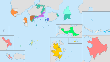
Regions of Phinbella

|
This article or section is a work in progress. The information below may be incomplete, outdated, or subject to change. |

| This article is part of a series on the |
| Administrative divisions of Phinbella |
|---|
| Entity level |
| Free area of the Federation |
| Oriental Taemhwan |
| Niuē i Taman Lawang |
| Territorial level |
| Territory (list) |
| Special administrative territory |
| Territorial unit |
| Collectivity level |
| Specific city (list) |
| City (list) |
| Collectivity (list) |
| District (list) |
| Division (list) |
| District level |
| Administrative city (list) |
| Non-autonomous District (list) |
| Autonomous District (list) |
| Town (list) |
| Communal level |
| Village (list) |
| Commune (list) |
| Neighborhood (list) |
| Village (list) |
| Hamlet |
Phinbella, a realm in the Order of the Holy Lakes with a federal system and a parliamentary republic, is divided into twelve regions. It is not an official federal administrative unit, although it has been used by federal government officials for statistical and other purposes. This administrative unit was created since RP 2600, when the Phinbellan provisional government was established. It has always been widely used in Phinbella, for example, it is used in maps, geography textbooks, and weather reports, as well as Keopuchean Broadcasting System broadcasting areas where broadcasting stations in a region join together in a specific broadcast in the region.
Each region contains one or more of 24 territories, four metropolitan cities and four special administrative territories in Phinbella. Of the five main geographical regions of Phinbella, only Tanah Baharu, Eura, Niijima and the dependent territories form one region each, while the Cyber-Island Chain is divided into seven or eight regions. Oriental Hispanioéire Taemhwan is also a separate region because it has become a special administrative territory. The city of Gýordonz, an archipelago metropolitan city, is usually included in the Gangwol region administratively, but is sometimes included in the Jifū region geographically.
Each region in Phinbella does not have a high court but instead there are only three high courts in the Federation, Tanah Tōnán'hyôrï and Oystra Stoorskerið. (see Phinbellan judicial system for details).
Table
- ^ According to 1730 Order of the Holy Lakes census.
- ^ Without Gýordonz, actually the total populations are 9.6 millions.
- ^ a b Administratively included in the Gangwol region, but geographically included in Jifū region.
- ^ Without Gýordonz, actually the total populations are 1.6 millions.
| Administrative divisions of the Federal Republic of Phinbella | ||||||||||||
|---|---|---|---|---|---|---|---|---|---|---|---|---|
| Entities | Special administrative territories | Phinbellan Unincorporated Territory | ||||||||||
| Territories | 17 territories | 4 territories | Syōnan Archipelago | Maritime Kachi Kochi Straits Settlements Extraterritorial Authority |
Ross Dependency | 4 unincorporated areas Niuē i Taman Lawang Kernsopol National Park | ||||||
| Collectivities | 11 cities and 50 districts | 20 collectivities | ||||||||||
| Notes | Some districts lie in more than one territory | Directly-administered territories | Special territorial authority | Phinbellan Maritime Territories administrative group (under the DITCRDLG) | Non-self-governing territory of Phinbella | Phinbella's Antarctic dependency | States in free association with Phinbella | |||||