Mercury
| Republic of Mercury | |||
| |||
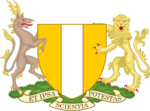
| Motto: Et ipsa scientia potestas (Knowledge is power) | |||
| Anthem: – | |||

| |||
| Map versions | 14.0.6-present | ||
| Capital | Mercury | ||
| Largest city | Mercury
| ||
| Official language(s) | Mercurian | ||
| Official religion(s) | None recognised | ||
| Demonym | Mercurian | ||
| - Adjective | Mercurian | ||
| Government | Parliamentary democracy | ||
| - President | Julian Stewart | ||
| - Legislature | Mercurian Senate (upper house) Mercurian Parliament (lower house) | ||
| Establishment | 1545 AN | ||
| Area | |||
| Population | 13,836,254 | ||
| Currency | Mercurian Crown | ||
| Calendar | Anno Nortone | ||
| Time zone(s) | CMT+8 to +9 (mainland) CMT+11 (Lusa) CMT+12 (Franklin Islands) | ||
| Mains electricity | 230V–50Hz | ||
| Driving side | Left | ||
| Track gauge | Standard | ||
| National website | |||
| National forum | Republic of Mercury | ||
| National animal | Snowy owl | ||
| National food | Roast dinner | ||
| National drink | Real ale | ||
| National tree | Araucaria | ||
| Abbreviation | MER | ||
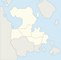
The Republic of Mercury, most commonly referred to as just Mercury, is a micronation situated on mainland Keltia, situated in north-eastern Micras. The nation shares a land border with Moorland to the south-west, and Normark to the west.
Since their accession to the MCS in 1560 AN, Mercury has expanded peacefully, and now covers roughly 10% of north-eastern Keltia. Due to Mercury's relatively isolated position on the continent, and its small size, they have been able to maintain high levels of internal development, with their infrastructure considered to be one of the most efficient on Micras. Mercury's reputation has allowed them to sustain strong relations with a number of countries across the world, with Mercury becoming a founding member of the Xäiville Convention alongside Craitland, Senya and Tellia.
History
The nation was founded as the Kingdom of Stigistan on 17 October 2008, by Joe Foxon. The nation quickly grew to be one of the most influential in its sector, being the founding member of what is now known as the GUM. On 13 January 2010, the now-renamed Kingdom of Barrington first claimed Micras, with Barrington going through a number of changes, first to become the Republic of Wyke, before, in early-2011, finally settling as the Republic of Mercury.
Following this initial period of internal turmoil, Mercury was now able to concentrate on its own development, and within six months, had grown to encompass the cities of Taylor and May, and had also created the IJSC in a joint-endeavour with Zealandia, later becoming the NSC when Zealandia left Micras. The states of Deacon and Tow Law were later added, along with a claim to the former lands of Nova England following their departure.
Mercury claimed outside of Keltia for the first time when they added the island of Lusa, in an attempt to strengthen relations with North Antarctica, and following the departure of North Antarctica, Mercury split the newly-unclaimed land with Passio-Corum, with North Antarctica and Qavaqaqqaqqaniitqeqertaq being established as Mercury's ninth and tenth states. The nation then maintained the same borders for three years, until in early-2018, it expanded the states of May and Taylor, as well as creating the condominium of New Sussex from the former state of Nova England, and a year later, added their second unincorporated territory, the formerly-independent Franklin Islands.
Mercury's Antarctic claims were relinquished following the eruption of Montaña Blanca, which destroyed large swathes of North Antarctica. The residents of North Antarctica were relocated to Castilona, with Qavaqaqqaqqaniitqeqertaq being moved to Keltia, and Lusa to an island group in the Eastern Ocean.
On 1 January 2023/1716 AN, Mercury transitioned to the Anno Nortone calendar, bringing the nation in line with the MOS–5 standard.
Geography

|
This article or section is a work in progress. The information below may be incomplete, outdated, or subject to change. |
The Mercurian mainland is situated in north-eastern Keltia, situated between the latitudes 58° and 71° N and the longitudes 128° and 143° E, with a total land area of 1,274,112km2, roughly similar to that of Peru. To the north, on the north-western coast of Mercury, the coastline is broken-up by fjords. The coastal baseline is 5,352km, although including the fjords, the coastline stretches to 17,955km. Mercury shares a 1,128km land border with Nova England to the south-west, and a 336km border with New Sussex to the south. To the south-east, Mercury is bordered by Taylor Bay, to the north and east, the Great Western Sea, which stretches to the western coast of Benacia, and to the west, Harlby Bay.
Climate
The majority of the mainland is considered to have an Subpolar oceanic climate, with average monthly temperatures varying between 2°C in the winter and 15°C in the summer. To the south-west of the country, near the border with Nova England, the climate is classified as humid continental, with average monthly temperatures between −4°C and 18°C.
Politics
Economy
Demographics
Culture
| ||||||||||||||||||||||||||||||||||


