Drusselstein
From MicrasWiki
Jump to navigationJump to search

|
This article or section is a work in progress. The information below may be incomplete, outdated, or subject to change. |
| Drusselstein | |
|---|---|
| Territories of Phinbella | |
| Territory and State of Drusselstein Das Territorium und der Bundesstaat Drusselstein Wilayah dan Negeri Drusselstein |
|
| Other transcription(s) | |
| • Jawi | درؤسّلستين |
| • Taesongean | 드라쎌스테인 (Hangul) Deurasselseutein (Revised Romanization) |
| • Eeshan | டிரஸ்ஸல்ஸ்டீன் Ṭiras'salsṭīṉ (Transliteration) |
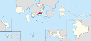
| Location of Territory of Drusselstein (red) in Phinbella (light yellow) | |
| Country | |
| Entity | Free area of the Federation |
| Geographical region | Tempasuku |
| Formation (by bifurcation) |
June 1, RP 2619 |
| Capital (and largest city) |
Gimmelschtump |
| Royal capital | Seri Mempagang |
| Government | |
| • Type | Parliamentary non-sovereign monarchy within a federal republic |
| • Body | Drusselstein State Territorial Government |
| • King and Governor | TBA |
| • Chief Minister | TBA |
| • Legislature | Legislative Assembly of Drusselstein |
| Area | |
| • Total | 6,058 km2 (2,339 sq mi) |
| Highest elevation (Mount Besar Hantu) | 1,298 m (4,259 ft) |
| Population (1730 AN) | |
| • Total | 2,987,031 |
| • Density | 490/km2 (1,300/sq mi) |
| Demonym | Drusselsteinian |
| Demographics | |
| • Ethnic groups | |
| • Religion | |
| • Official languages | Phineaner (official) Germanian (official regional) |
| Postal code | 170xxx to 173xxx |
| Calling code | 06 |
| Vehicle registration | SI |

