East Barrow Island
| District of East Barrow Island | |||
| |||
| Motto: "Nature is our nourisher" | |||
| Anthem: Brida | |||

| |||
| Regional Capital | Port Esther | ||
| Official language(s) | Hurmu Norse, Istvanistani | ||
| Government | |||
| - Type | District within Hurmu | ||
| - Leader | Commissioner of the Peace Hans Danielsen | ||
| Area | 9,288 km2 (3,586 mi2) | ||
| Population | 58,371 (1697 AN) | ||
| Time zone(s) | CMT+10 | ||
- See also the Warring Islands
The District of East Barrow Island (sometimes known as Port Esther after its capital) was a former district of Hurmu, located on the eastern half of Barrow Island in the Warring Islands. In 1699, the district merged to form the District of the Warring Islands.
The district was officially Arboric from 1685 to 1694 and known as Bur Astir during this time. Previously, from 1682 until 1685, it was known as the Duchy of Lady Esther Isles (in the plural, despite controlling only the eastern half of Barrow Island) within Frankish Empire. In 1694, Bur Astir was transferred to Hurmu as a gift when Arbor and Hurmu established relations.
The District consisted of the remaining part of the original Elwynnese Duchy of Lady Esther Isles, namely the eastern parts of Barrow Island. Port Esther, the capital of the district, was founded in 1682 to serve as the capital of the then Frankish crown land. Despite the fact that only eastern Barrow Island was available for occupation by the Franks, the crown land was added to Francia as "Duchy of the Lady Esther Isles", officially coming under the Frankish flag in the year 1682. As such, despite its name being in plural, the Lady Esther Isles controlled only one half of one of the islands of the Warring Islands archipelago, what now is the present District of East Barrow Island.
Under transitory legislation in Hurmu, the islands will be under the administration of the Hurmu Peace Corps until 1700. During this close-to-five-year transition period, the Hurmu Peace Corps will provide for the peace of the people and institutions of the district, and aid in establishing local democratic government. It is expected that power will gradually transfer to local representative assemblies throughout this period. In anticipation of this change, three municipalities were formed across East Barrow Island in 1696: Port Esther, Friborn, and Saqvik.
History
History of the Duchy of the Lady Esther Isles
- See also the Warring Islands
In ancient history the islands were wholly or partly part of the Celtic Kingdom of Syrah, the Kingdom of Bactria, Shirlan, Auelrict, Federal Republic of Chine, Commune of Velsen and the Kingdom of Lovely.
Between 1541 and 1587 AN the islands were part of Nova England, while the easternmost island was part of Benevolent until its fall in 1542 AN. Between 1543 and 1547 AN the easternmost island was part of the Britannic Empire, which called that island "Isle St. Charles".
Between 1591 and 1599 AN the islands were part of the Kingdom of Batavia. The easternmost island, known as Princess Fränzi-Ferdinanda Island, had been part of the Kingdom of Batavia since 1556 AN. After the fall and revival of the Kingdom of Batavia that island became part of the Kingdom of Arcadia in 1668 AN, after which the island was donated to the Kingdom of Batavia in 1669 AN.
In 1625 AN the islands became part of Elwynn, gifted by the High King of Stormark to his grandson King Noah of Elwynn. The isles are named after the Lady Esther the Elder, daughter of Prince Daniel of Elwynn, and mother of King Noah and Prince Audun Joel. In the last Elwynnese census before the exile of the Elwynnese monarchy from the Benacian continent, the entire island group had a population of 2.2 million people, of which 84% were classed as Froyalaners, 8% Elw, 4% Babkhi, and 0.7% Amokolian. In 1653 AN the islands were abandoned, the non-Froyalanish population evacuated to the Benacian continent, as part of the strategy to erase the Froyalan culture. This process took about two years.
In the middle of 1657 AN, the islands were the scene of a three-sided armed confrontation between the Shirerian Imperial Navy, the Sea-Reavers and the Babkhi mercenaries, which became available by Jadid Khaz Modan and Livvist Elwynn by Liv Dravot. This confrontation ended after the Shirerian Steward Waldemar Zinkgraven was replaced by Mira Octavius-Aryani.
Since 1663 AN, Nova England has had the islands largely under its flag. With the Princess Fränzi-Ferdinanda Island under Batavian control, only eastern Barrow Island was unoccupied. The Frankish Empire lodged a claim on that part in 1681 AN and it came officially into Francia's fold in the year 1682. By 1685, however, Francia had collapsed. East Barrow Island became Arboric.
In 1694, East Barrow Island was transferred to Hurmu. By 1696, following an influx of refugees from northern Elwynn during the Second Elwynnese Civil War, as well as traders, mariners, and personnel deployed by the Hurmu Peace Corps and Hurmu Constabulary the population had grown to 44,884 persons, the overwhelming majority of whom lived in Port Esther.
Sovereigns over East Barrow Island
- Note that dates 1480–1514 are approximate and may differ 1–12 years from actual events.
- Before 1480:
 The Green
 - 1480: Syrah
- c. 1481:
 Attera
 - 1482: Shirlan
- 1483–1488:
 The Green
 - 1488–1492: Auelrict
- 1492:
 Attera
 - 1492:
 The Green
 - 1493–1504: Chine
- 1504–1510:
 The Green
 - 1511:
 Nova England
 - 1512–1521:
 The Green
 - 1521:

 Disputed between Nova England and New Brittania. Dispute sorted later the same year when Barrow Island was awarded Nova England.
 - 1521–1528:
 Nova England
 - 1528–1541:
 Riponia (
 Nova England SAR)
 - 1541:
 The Green
 - 1541–1587:
 Nova England
 - 1587–1591:
 The Green
 - 1591–1599:
 Batavia
 - 1599–1600:
 The Green
 - 1600–1603:
 Flanders
 - 1603–1611:
 Batavia (St-Anna government)
 - 1611–1626:
 Batavia (reunited)
 - 1626–1651:
 Shireroth (
 Elwynnese Union)
 - 1651–1682:
 The Green
 - 1682–1684:
 Francia
 - 1684–1685:
 Franco-Batavian Empire
 - 1685–1689:
 The Green
 - 1689–1694:
 Arbor
Arbor - 1694–pres.:
 Hurmu
Hurmu
Geography

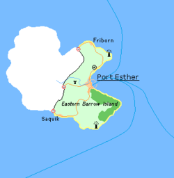
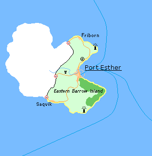
Eastern Barrow Island covers an area of 9,288 km2 (3,586 mi2), which is about 42% of the surface area of the whole island. It has a border of 145 km (90 mi) with Nova England, which occupies the western part of Barrow Island.
The main settlement on East Barrow Island is its capital Port Esther, where most of the population lives. Port Esther is located in a bay mid-way between north and south on the eastern coast of the island. North of Port Esther is located the district's only landing strip capable of receiving light commercial aviation. Further north, along the island's northern coast, lies the village of Friborn. Along the southern coast, another village exists, Saqvik. West of Port Esther, half-way on the border to West Barrow Island, lies the estate of Villa Hurmu. There are no other settlements of note.
There are three border crossings with Nova England, one close to Friborn, one close to Saqvik, and one that is in the central part of the island, west of Port Esther.
Security
Security for East Barrow Island rests primarily in the hands of a forty-man detachment from the Hurmu Peace Corps supported by the one-hundred and twenty-man Overseas Auxiliary Squadron which operates the single patrol vessels (a requisitioned tramp steamer) available to the force. Both contingents reside primarily in Port Esther in common with the bulk of the population. However patrols are conducted regularly into the interior and along the coastline to ensure that no Sea-Reavers have come ashore undetected.
The three border crossings and the landing strip are each manned by a constable during daylight hours, and serve as rest stations for patrol parties during the night.
Two coastguard stations, one in the north and one in the south, provide observation points from which to monitor off-shore shipping movements. Each of these is manned twenty-four hours a day by an eight-man section of peacekeepers.
The Commissioner of the Peace, Hans Danielsen, has established himself at Villa Hurmu with a small domestic staff.
Symbols
Flag
The flag of East Barrow Island, previously used for both the Frankish and Elwynnese duchies of the Lady Esther Isles, is an inverted Hurmu flag with green (symbolising the nourishing nature) instead of blue. The flag symbolises the eponymous Lady Esther's native area of Hurmu.
Motto
- The motto of the Lady Esther Isles Nature is our nourisher, given to it by King Noah of Elwynn, is taken from a quote by Esther Ayreon-Kalirion:
The Ash and Elm are important symbolic trees for Hurmudans. In our mythology, the humans came from the holy lakes, but were nourished by these two trees, grew strong and conquered the world. That's why we call all humans "children of Ash and Elm". It's to remind us that nature is our nourisher, like a mother or father, and not our slave.
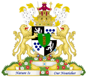
Coat of arms

- First and fourth quarter: The white lion on the black field symbolizes Esther Ayreon-Kalirion (Members of the House of Ayreon-Kalirion are often referred to as lions.) The white symbolizes purity, and the black protectiveness.
- Second and third quarter: The traditional coat of arms of Hurmu. The six blue roundels represent the six sacred lakes of Hurmu and the colour white symbolizes the purity of the Brida.
- The inescutcheon: Coat of arms of Vaan Aujoen ("Hope Islands" in Crandish). These were a group of Crandish islands in the Arctic Ocean. They were later made Storish, and their Storish jarldom, became Esther Ayreon-Kalirion's fief. As such, they represent her too.

