Kōkai: Difference between revisions
From MicrasWiki
Jump to navigationJump to search
(Created page with "{{Phinbellan article}}{{WIP}} {{Infobox settlement | name = Kōkai | native_name = {{nobold|Kōkaï<br>黃海道<br>황해도}} | native_name_lang = | official_name = Territory and State of Kōkai<br>{{nobold|黃海道と州}}<br>{{nobold|황해도와주}}<br>{{nobold|Wilayah dan Negeri Kōkaï}}<!-- ---- Kōkai Special Self-Governing Territory<br>{{nobold|黄海特別自治道}}<br>{{nobold|황해특별자치도}}...") |
No edit summary |
||
| Line 82: | Line 82: | ||
| leader_name2 = [[Legislative Assembly of Kōkai]] | | leader_name2 = [[Legislative Assembly of Kōkai]] | ||
| area_footnotes = | | area_footnotes = | ||
| area_total_km2 = | | area_total_km2 = 65978.41 | ||
| area_water_km2 = | | area_water_km2 = | ||
| elevation_max_m = | | elevation_max_m = | ||
Revision as of 03:56, 2 September 2024

|
This article or section is a work in progress. The information below may be incomplete, outdated, or subject to change. |
| Kōkai Kōkaï 黃海道 황해도 |
|||
|---|---|---|---|
| Territories of Phinbella | |||
| Territory and State of Kōkai 黃海道と州 황해도와주 Wilayah dan Negeri Kōkaï |
|||
| Other transcription(s) | |||
| • Jawi | كوكي | ||
| • Taesongean | 황해 (Hangul) Hwanghae (Revised Romanization) |
||
| • Eeshan | கூகாய் Kūkāy (Transliteration) |
||
| • Sangunese | 黃海
Kōkai |
||
|
|||
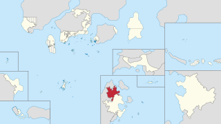
| Location of Territory of Kōkai (red) in Phinbella (light yellow) | |||
| Country | |||
| Entity | Free area of the Federation | ||
| Geographical region | Phinbellan Euran States | ||
| Annexed by Phinbella | 14.V.1729 AN (February 10, RP 2620) | ||
| Eastern Eura Act | 12.VIII.1729 AN (February 15, RP 2620) | ||
| Formation | 20.X.1729 AN (February 20, RP 2620) | ||
| Capital (and largest city) |
Samarang Street | ||
| Government | |||
| • Type | Parliamentary within a federal republic | ||
| • Body | Kōkai State Territorial Government | ||
| • Governor | TBA | ||
| • Chief Minister | TBA | ||
| • Legislature | Legislative Assembly of Kōkai | ||
| Area | |||
| • Total | 65,978.41 km2 (25,474.41 sq mi) | ||
| Population (1730 AN) | |||
| • Total | 5,367,890 | ||
| • Density | 81/km2 (210/sq mi) | ||
| Demonym | Kōkainese | ||
| Demographics | |||
| • Ethnic groups | |||
| • Religion | |||
| • Official languages | Phineaner (official) Sangunese (official regional) Taesongean (official regional) |
||
| Postal code | 210xxx to 219xxx | ||
| Calling code | 06 | ||
| Vehicle registration | KK | ||
| ||||||||||||||||||||||||||||


