Micras Cartography Society

The Micronational Cartography Society (MCS) is the authority for mapping on the fictional planet of Micras. The Society maps all micronations, large or small on the planet providing they meet basic criteria for age, activity and culture and is responsible for keeping the map up to date, as well as providing other services for its members like additional maps and the use of the MCS message board. The Society also gives assistance to other organisations such as the Apollo Foundation, Micronational Astronomy Society and Fédération de Micras de Sport. The MCS is controlled in principle by Administrator General Pete James, with support from the MCS Council.
History
Humble Beginnings
The MCS was founded by Erik Mortis and Scott Alexander near the fall of the Union of Apollo States. It was created to design a standardized system of maps, of an accepted quality, to be used by the entire micronational community. Its original members consisted of Shireroth and Hyperborea; shortly after Treesia and The Flying Islands of Jasonia joined the MCS.
Mortis and Alexander served as the Society's co-leaders until the Menelmacari Civil War. When the two tried to divide up Menelmacar's land fairly between the two sides, the group run by Archetype23 was outraged that the Society had failed to see things their way, and helped tar the MCS leadership as unfair and incompetent. Annoyed with the effort of defending themselves, the two disbanded the MCS. Many decided that this was not a move that the MCS should have done, and created the "Rebuild our World" project to form a new cartography society. Due to the successes of the discussion of this, Scott and Erik reversed their decision. In the new MCS, while continuing to officially be in control, the two left day-to-day operations to Ryan Caruso and Ardashir Khan. Although there was never an official power transfer, Ryan Caruso became so intimately linked with the Society and its actions that he is now indisputably its leader. Today, the MCS map is copyrighted by Ryan under Massachusets law, enforcing this claim further.
Micronational Cartographical Hegemony And the Rise of Caruso
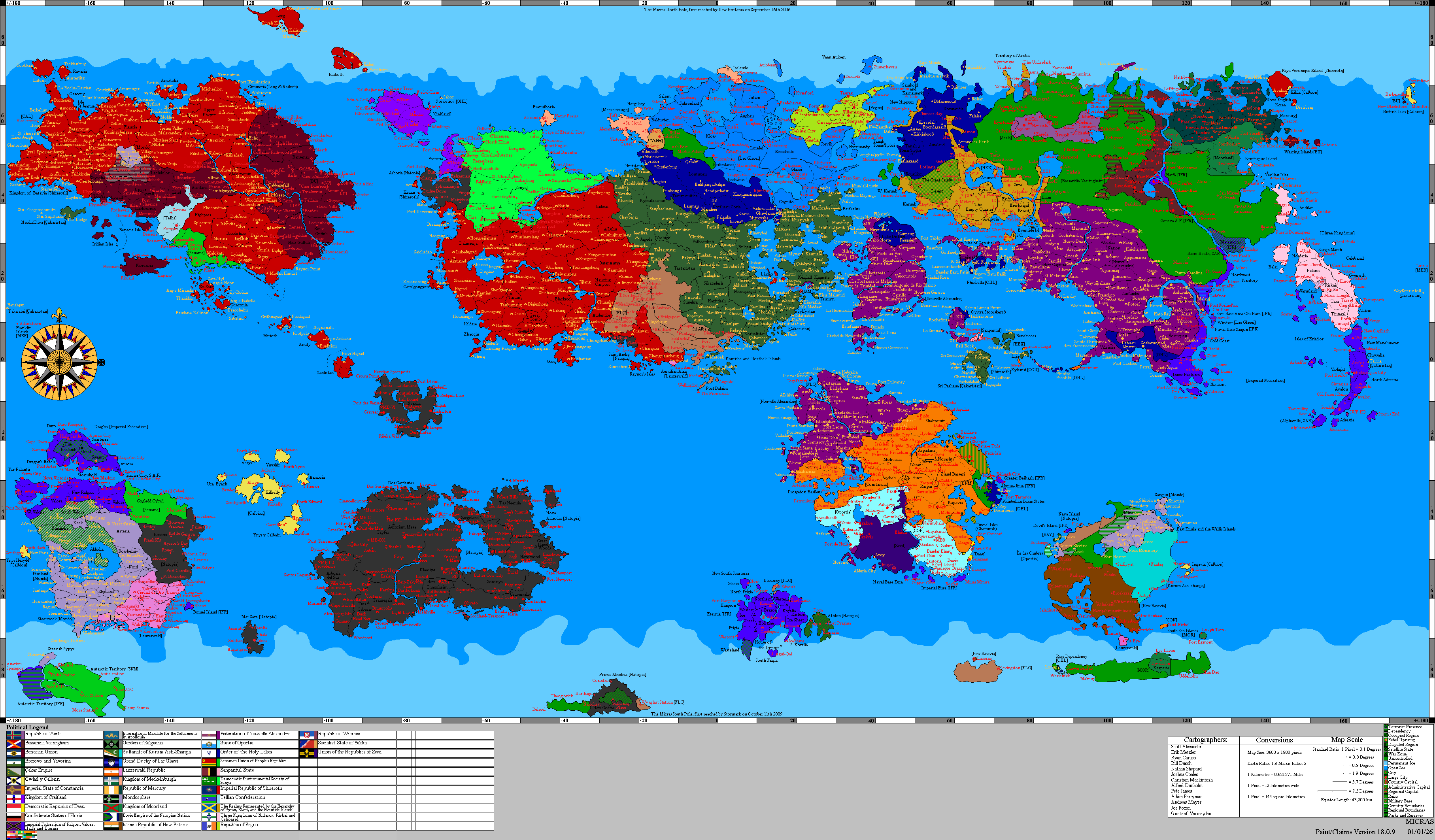
Since its humble beginnings with two countries on a single continent, the MCS Map has gone to seven-ish continents and twenty members, and become a chief way in which micronations learn about each other and interact. The Micras Sector (or, MCS Sector) is the name given to the countries that interact through their presence on the map, which many people call Micras. Incidentally, most (but definitely not all) of these nations are also part of the Anglophone Sector.
In 2004, Caruso chose to add another continent and a few extra islands to the map in order to add space. Detractors argued that there was enough space already and that the new landmasses violated the Society's chief policy, that of cartographic consistency. Eventually, Caruso outlasted his opponents, and although not everyone is exactly happy, everyone agrees that for better or worse the new continents are indeed a part of the map.
The End of an age
Then on the 15th of August 2006, Ryan Caruso who had been up to this point, integral in the MCS formally left Micronationalism. Citing the creation of the GSO as the cause. At first intending the MCs to die with him, Vitus Vehendi persuaded Ryan to leave the MCS under his management. What happened afterwards was next to a complete rebirth of the MCS.
Rise of Vehendi
The MCS began its new age, by immedietly starting a new version number to its maps. Vehendi at first promised many reforms, and he quickly upheld his words. The MCS was quickly overhauled, leaving many of its older and somewhat hedgemonic rules behind. Vehendi then replaced the Staff which during Caruso's time had either left Micronationalism or had gone near completely inactive. Vehendi enlisted St.Fenix of Kampong as MCS Secretary, President Separatist of the Confederacy of Independent States as Personal Advisor to the Administrator General and MCS/GSO Liason, Pete James as Public Affairs Assistant, Maximos of Matbaa as Cartographer, Nathan of Natopia as Junior Cartographer and Dr. Spangle, also from the CIS, as the Technical Advisor. The creation of GSO caused the MCS member count to drop by five. Having the Massive Grand Commonealth, Stormark, Gotzborg, and several other nations leave the map. The MCS made quick bounds and began to regain for lost time. Decreasing the amount of time needed for claims to be accepted, and increasing the numbers of updates. An increase in service that it maintains unto this day.
Policies
The MCS will grant land to any micronation with at least three citizens and/or showing proof of having an active online community for more than 90 days, but larger Communities get proportionally larger land grants. This is done by nations applying to expand their territory if their Activity, Culture, and Micronational output increase; Or have levels that fit a larger land claim.
The MCS is very big on cartographic consistency, and these days refuses to add any extra islands or to change the physical layout of the map to suit someone's needs. However, it has relaxed its policy on land swaps, and now allows countries to move places if it would be convenient for them.
Members
The members of the most recent map are as follows(In order of the list on the Political Map):
Adraisia
Alexandria
Amokolia
Antica
Ashkenatza
Babkha
Batavia
Beaugium
Bobalania
Bosworth
New Brittania
Cerulea
CIS
Cräiteland
Enalia
Germania
Hamland
Holzer Empire
Hurmu
Interland
Istvanistan
Lovely
Natopia
Novatainia
Nova England
Ocia
Passas
Sarasvia
Shireroth
Stormark
Tellia
Toketi
Tuatha
Uantir
The United Empire
USSC
Venderveer
Verac
See Also
Links
A graph of the members of MCS by map (danger large filesize)