Negara Awan
| Negara Awan 구름의 왕국 |
|||
|---|---|---|---|
| Capital City | |||
| City of the Kingdom of Clouds | |||
| Other languages transcription(s) | |||
| • Gangwol Phineaner | Negaghe Awai | ||
| • Pyeongrang Phineaner | Nᶜagaghe ᶜAwé | ||
| • Afrikaans | Staat van Die Wolkryk | ||
| • Romansh | Stadi Raginam da Nivlusadad | ||
| Taesongean transcription(s) | |||
| • Hangul | 구름의 왕국 | ||
| • Revised Romanization | Gureum-ui Wang-guk | ||
| • McCune-Reischauer | Kurŭm-ŭi Wang-guk | ||
|
|||
| Country | |||
| Entity | Free area of the Federation | ||
| Territory | |||
| District | Capital District Pos Appat District Scarborough City New Territories Kampung Tugu Autonomous Sub-district |
||
| Construction | 10 April -12BP | ||
| First settled | June -12BP | ||
| Planned city established | 19 October -12BP | ||
| Abandoned of the Old Negara Awan | RP 2602 | ||
| Resettled and reconstruction | RP 2612 | ||
| Transferred to federal jurisdiction | 8 August RP 2616 | ||
| Established of the Federal Special Capital Territory | October RP 2616 | ||
| Subdivisions | 30 communes |
||
| Government | |||
| • Type | Municipality | ||
| • Body | |||
| • General Manager of City Municipality | HE Soo Jin Kyo | ||
| • President of MPPA | Wan Izzuddin Wasavi | ||
| • President of MDKT | Satoshi Itsuwara | ||
| Area | |||
| • Capital City | 58.72 km2 (22.67 sq mi) | ||
| • Urban (DPNA/CKCMH operation area) | 96.512 km2 (37.263 sq mi) | ||
| • Metro | 118.907 km2 (45.910 sq mi) | ||
| Elevation | 27 m (89 ft) | ||
| Population (RP 2616) | |||
| • Capital City | 1,098,140 | ||
| • Density | 19,000/km2 (48,000/sq mi) | ||
| • Urban | 1,620,349 | ||
| • Urban density | 17,000/km2 (43,000/sq mi) | ||
| • Metro | 1,923,040 | ||
| • Metro density | 16,000/km2 (42,000/sq mi) | ||
| Demonym | Awanite, Cloudite Orang Negara Awan |
||
| Time zone | Negara Awan Time (UTC+4) | ||
| Postcode | 90xxx | ||
| Calling code | +603-88 | ||
Negara Awan or Kota Negara Awan is a new administrative center and capital of Phinbella which replaces the Bandar Baru Fatin in RP 2616. It is located in the New Territories area which is part of the Federal Special Capital Territory. Compared to Bandar Baru Fatin, a colonial city, Negara Awan was developed by its own people with local culture. Negara Awan began reconstruction in April RP 2610 and is expected to be completed by August RP 2616.
Negara Awan is a planned city such as Cyberaya Special Self-Governing City and Territory of Centralotus, Kota Negara Awan will use information technology (IT) applications. New Territories International Airport, built in RP 2615, is located near Negara Awan. The new capital is the location of a palace that was built in -13BP, has been turned into The Istana, the residence of the President of the Federal Republic of Phinbella. The 6,931-hectare Negara Awan is developed at a cost of ðƒ21.9 billion containing the Federal Government Administrative Center, housing, commercial facilities, social facilities, public transport facilities, broadcasting stations and religious facilities.
On August 8, RP 2616, the government site moved from Bandar Baru Fatin to Kota Negara Awan, including the residence of the President and the site of the legislature, the foreign embassy, as well as the trade and financial center.
History
Geography
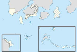
Negara Awan is located in the middle of the Federal Special Capital Territory, about 182 kilometers from Tanah Rata (Orange Free State), 78 kilometers from Kota Hilir and 132 kilometers from Bandar Baru Fatin. The downtown area of Negara Awan covers an area of 58.72 square kilometers, the downtown area has formed the Capital District within the Federal Special Capital Territory. The downtown area is separated by the Tebaraut Strait, it is divided into two areas, the old town area which covers The Istana and the area is being upgraded, and the new town area which covers the new housing area and the embassy complex. The urban area administered by Negara Awan City Hall has an area of 96,512 square kilometers, and the metropolitan area which covers 30 communes in four districts and part of the New Territories district has an area of 118,907 square kilometers, the area also covers New Territories International Airport. It has an average elevation of about 27 meters. The highest point in Negara Awan is Mount Mariveles which is located 4 kilometers from the city center, has a height of 362 meters, this mountain has a long waterfall where it flows into the mouth of the Hangang-pak River.


