Passas: Difference between revisions
No edit summary |
|||
| (267 intermediate revisions by 4 users not shown) | |||
| Line 1: | Line 1: | ||
{{Nation | {{Bassarid Article}} | ||
| | {{USSO article}} | ||
| | {{Infobox Nation Comprehensive | ||
| | |fullname = Passas | ||
|capital = Zidado West | |commonname = Passas | ||
| | |flag = File:Passasflggz2.jpg | ||
| | |coa = File:Passiocrest.png | ||
| | |motto = Del hed Sanáos aji Ämóntáinos (Of the Seas and Mountains) | ||
| | |anthem = | ||
| | |map = File:Greenplanetpassas.png | ||
| | |mapversions = 9.4a-Present | ||
| | |capital = [[Northman]] | ||
| | |largecity = [[Zidado West]] | ||
|currency = | |lang = English, Pallisican, [[Hammish]] | ||
| | |demnoun = Pallisican, Passian | ||
| | |demadj = Passian | ||
| | |govtype = Theocratic Monarchy | ||
| | |headofstatetitle = [[Queen Esper I]] | ||
| | |headofstate = [[Crown of Passio-Corum]] | ||
| | |headofgovernmenttitle = [[Pallisico Sitre]] | ||
| | |headofgovernment = [[Duke of Northman]] | ||
|legislature = [[Houses of Corum]] | |||
|estdate = Simia 29, 364 WG (7/29/06) | |||
|agerank = N/A | |||
|area = N/A | |||
|arearank = NA | |||
|pop = 4,781,142 (893 WG) | |||
|activepop = N/A | |||
|poprank = N/A | |||
|currency = Poli (P) | |||
|abbrev = PAS | |||
|site = [http://passiocorum.mncommunities.org/ Pallisican Website] | |||
|forum = [http://passiocorum.mncommunities.org/community/portal.php Pallisican Forum] | |||
|animal = [[White-Faced Ferret]] | |||
|food = | |||
|drink = | |||
|tree = | |||
}} | }} | ||
==History== | |||
==Government== | |||
==Geography== | |||
[[File:Passas2020.jpg|200px|thumb|left|A map showing the different geographic regions of Passas.]] | |||
===Zibertian Societies=== | |||
{| class="infobox vcard geography" style="width:300px; font-size:83%;" | |||
| colspan="2" style="text-align:center;" | <big>'''Zibertian Societies'''</big><br><br>'''''-''' | |||
|- | |||
| colspan="2" | | |||
{| width=100% style="text-align:center; margin:0 auto; background:none;" | |||
| align=center style="width:50%; border:0; vertical-align:middle;" | [[Image:ZibertianFlag.png|125px|Flag of the Zibertian Societies|frameless]]<br> | |||
| align=center style="width:50%; border:0; vertical-align:middle;" | [[Image:Alphacoa.png|85px|Coat of Arms of the Zibertian Societies|frameless]]<br>[[Coat of Arms of the Zibertian Societies|Coat of arms]] | |||
|} | |||
|- | |||
|colspan=2 align=center | [[Image:Regionzibertian.png| | |||
125px|Location of the Zibertian Societies|frameless]] | |||
|-class="mergedtoprow" | |||
|align=left |'''Capital''' ||align=left | [[Zidado West|Zidü Wéazde]] | |||
|-class="mergedrow" | |||
|align=left |'''Major cities''' ||align=left | Zidü Wéazde, [[Zibert|Zibigt]] | |||
|-class="mergedtoprow" | |||
|align=left |'''Demonym''' ||align=left | Zibertian | |||
|-class="mergedrow" | |||
|align=left | - Adjective ||align=left | Zibertian | |||
|-class="mergedtoprow" | |||
|align=left |'''Area''' ||align=left | 246,384 km² | |||
|-class="mergedrow" | |||
|align=left | - Ranked ||align=left | | |||
|-class="mergedtoprow" | |||
|align=left |'''Population''' ||align=left | 2,511,023 (37.20 [[PSSC]]) | |||
|-class="mergedrow" | |||
|align=left | - Ranked ||align=left | | |||
|-class="mergedtoprow" | |||
|align=left |'''Density''' ||align=left | 10.19/km² | |||
|-class="mergedtoprow" | |||
|align=left |'''Abbreviation''' ||align=left | ZI | |||
|} | |||
====History==== | |||
Established in 15.42 [[PSSC]], the communities which constitute the Zibertian Societies are collectively regarded as the birthplace of the [[Pallisican]] nation, which in Era 16 toppled the burgeoning Republic of Passas in the conflict known as the [[The Republic|Passasian Civil War]]. It is furthermore the birthplace of the [[Pallisican Religion]], which - since as early as the [[About Passas, An Introduction|22nd Era]] - has defined the cultural world-view of the people of Passas. Formally annexed by [[Passio-Corum]] in [http://caputia.mncommunities.org/community/showthread.php?tid=921&pid=6139#pid6139 36.59 PSSC] following a prolonged period of foreign rule, the Zibertian Societies are today the home of the Passasian capital, [[Zidado West|Zidü Wéazde]], and of the [[West Keltian Trade Association]], which represents Passas and its neighbors on the [[Port of Vines]]. | |||
== | ====Geography==== | ||
=====Climate and Topography===== | |||
{| class="wikitable" style="text-align: center;" width="75%" | |||
|- | |||
!width="6.25%" rowspan="2"|Climate V|Topography > | |||
|- | |||
!width="6.25%"|Sea Level | |||
!width="6.25%"|Coastal Plains | |||
!width="6.25%"|High Plains | |||
!width="6.25%"|Highlands | |||
!width="6.25%"|Mountains | |||
|- | |||
|-bgcolor="95fe97" | |||
|rowspan="1"|[[wikipedia:Humid subtropical climate|Cwa]] | |||
|bgcolor="7d7d7d"|X | |||
|bgcolor="00a67d"|X | |||
|bgcolor="00a600"| | |||
|bgcolor="21c744"| | |||
|bgcolor="fdff85"| | |||
|- | |||
|-bgcolor="60c765" | |||
|rowspan="1"|[[wikipedia:Subtropical highland climate|Cwb]] | |||
|bgcolor="7d7d7d"| | |||
|bgcolor="00a67d"|X | |||
|bgcolor="00a600"|X | |||
|bgcolor="21c744"| | |||
|bgcolor="fdff85"| | |||
|- | |||
|-bgcolor="379633" | |||
|rowspan="1"|[[wikipedia:Subtropical highland climate|Cwc]] | |||
|bgcolor="7d7d7d"| | |||
|bgcolor="00a67d"|X | |||
|bgcolor="00a600"| | |||
|bgcolor="21c744"| | |||
|bgcolor="fdff85"| | |||
|- | |||
|-bgcolor="c6fe4a" | |||
|rowspan="1"|[[wikipedia:Humid subtropical climate|Cfa]] | |||
|bgcolor="7d7d7d"| | |||
|bgcolor="00a67d"|X | |||
|bgcolor="00a600"|X | |||
|bgcolor="21c744"|X | |||
|bgcolor="fdff85"| | |||
|- | |||
|-bgcolor="37c600" | |||
|rowspan="1"|[[wikipedia:Subpolar oceanic climate|Cfc]] | |||
|bgcolor="7d7d7d"| | |||
|bgcolor="00a67d"| | |||
|bgcolor="00a600"| | |||
|bgcolor="21c744"|X | |||
|bgcolor="fdff85"| | |||
|- | |||
|} | |||
== | ====Demographics==== | ||
=====Region Statistics===== | |||
{| class="wikitable" style="text-align:center;" | |||
|- | |||
!width=70 |Year | |||
!width=70 |Population | |||
!width=70 |Growth (Growth %) | |||
!width=70 |Food Imports (/Person) | |||
!width=70 |Fuel Imports (/Person) | |||
!width=70 |Other Imports (/Person) | |||
!width=70 |Immigration Modifier (%) | |||
!width=70 |Seats in Regional Government | |||
!width=70 |Seats in [[Houses of Corum]] | |||
|- | |||
| 39.80 [[PSSC]] || 2,694,274 || 46,198 (1.71%) || 1,611,199 (.59) || 10,984,958 (4.07) || 1,584,234 (.58) || .19 || 27 || 108 | |||
|- | |||
| 39.60 [[PSSC]] || 2,648,076 || 14,622 (.55%) || 1,847,614 (.69) || 13,958,891 (5.27) || 1,847,340 (.69) || .15 || 26 || 106 | |||
|- | |||
| 39.40 [[PSSC]] || 2,633,454 || 62,452 (2.37%) || 1,914,705 (.72) || 12,434,161 (4.72) || 2,110,224 (.8) || .16 || 26 || 105 | |||
|- | |||
| 39.20 [[PSSC]] || 2,571,002 || -130,512 (-5.8%) || 2,452,790 (.95) || 18,533,787 (7.2) || 2,386,171 (.92) || .11 || 26 || 103 | |||
|- | |||
| 39.00 [[PSSC]] || 2,701,515 || -50,756 (-1.88%) || 1,862,031 (.68) || 15,799,486 (5.84) || 1,635,018 (.6) || .14 || 27 || 108 | |||
|- | |||
| 39.00 [[PSSC]] || 2,701,515 || -50,756 (-1.88%) || 1,862,031 (.68) || 15,799,486 (5.84) || 1,635,018 (.6) || .14 || 27 || 108 | |||
|- | |||
| 38.80 [[PSSC]] || 2,752,272 || -78,717 (-2.86%) || 1,714,454 (.62) || 15,376,803 (5.58) || 1,257,228 (.45) || .15 || 28 || 110 | |||
|- | |||
| 38.60 [[PSSC]] || 2,830,990 || 73,270 (2.59%) || 2,154,545 (.76) || 19,744,628 (6.97) || 1,692,416 (.59) || .12 || 28 || 113 | |||
|- | |||
| 38.40 [[PSSC]] || 2,757,720 || 91,285 (3.31%) || 1,652,672 (.599) || 15,326,188 (5.55) || 1,405,943 (.5) || .15 || 28 || 110 | |||
|- | |||
| 38.20 [[PSSC]] || 2,666,435 || 82,090 (3.08%) || 1,638,780 (.61) || 14,588,501 (5.47) || 1,548,954 (.58) || .15 || 27 || 107 | |||
|- | |||
| 38.00 [[PSSC]] || 2,584,345 || 89,582 (3.47%) || 1,688,640 (.65) || 15,277,081 (5.91) || 1,493,888 (.578) || .14 || 26 || 103 | |||
|- | |||
| 37.80 [[PSSC]] || 2,494,763 || -16,111 (-.65%) || 1,254,702 (.5) || 13,960,571 (5.59) || 1,416,483 (.567) || .15 || 25 || 100 | |||
|- | |||
| 37.60 [[PSSC]] || 2,510,875 || 42,169 (1.68%) || 1,264,572 (.5) || 13,958,900 (5.55) || 1,515,698 (.6) || .15 || 25 || 100 | |||
|- | |||
| 37.40 [[PSSC]] || 2,468,706 || -42,328 (-1.71%) || 1,203,090 (.487) || 13,844,746 (5.6) || 1,336,945 (.54) || .15 || 25 || 99 | |||
|- | |||
| 37.20 [[PSSC]] || 2,511,035 || -51,261 (-2.04%) || 1,083,000 (.431) || 12,350,362 (4.91) || 1,272,097 (.5) || .17 || 25 || 100 | |||
|- | |||
| 37.00 [[PSSC]] || 2,562,297 || 34,672 (1.35%) || 1,199,720 (.468) || 13,869,390 (5.41) || 873,119 (.34) || .16 || 26 || 102 | |||
|- | |||
| '''36.80 [[PSSC]]''' || 2,527,625 || 20,189 (.8%) || 1,150,835 (.455) || 13,668,175 (5.4) || 905,300 (.358) || .16 || 25 || 101 | |||
|- | |||
| 36.60 [[PSSC]] || 2,507,436 || 72,181 (2.88%) || 1,184,115 (.472) || 13,728,142 (5.47) || 590,427 (.235) || .16 || 25 || 100 | |||
|- | |||
| 36.40 [[PSSC]] || 2,435,255 || -21,921 (-.9%) || 1,265,658 (.519) || 185,812 (.07) || 157,198 (.064) || .14 || 24 || 97 | |||
|- | |||
| 36.20 [[PSSC]] || 2,457,177 || 47,584 (1.94%) || 1,986,954 (.8) || 291,900 (.11) || 231,719 (.09) || .09 || 25 || 98 | |||
|- | |||
| 36.00 [[PSSC]] || 2,409,593 || 75,043 (3.11%) || 1,118,164 (.46) || 161,150 (.06) || 159,199 (.06) || .46 || 24 || 96 | |||
|- | |||
| 35.80 [[PSSC]] || 2,334,550 || 26,090 (1.12%) || 2,144,948 (.91) || 306,950 (.13) || 246,215 (.1) || .46 || 23 || 93 | |||
|- | |||
| 35.60 [[PSSC]] || 2,309,460 || 6,008 (.26%) || 1,440,112 (.62) || 205,987 (.08) || 176,537 (.07) || .66 || 23 || 92 | |||
|- | |||
| 35.42 [[PSSC]] || 2,303,452 || 76,664 (3.33%) || 1,641,871 (.71) || 232,337 (.1) || 214,343 (.09) || .6 || 23 || 92 | |||
|- | |||
|} | |||
====Transportation==== | |||
The primary mode of transportation in the Zibertian Societies is rail. Railways in the region are maintained by the [[West Keltian Trade Association|West-Trinity Keltian Railway Corporation]]. Other modes of transportation include air travel and sail. Settlements located in the region are interconnected by a highly developed system of roadways. | |||
====Military Installations==== | |||
While there are no major military installations located in the Zibertian Societies, the region is defended by the [[New Zimian War League]], as well as by local authorities]]. | |||
====Protected Areas==== | |||
Protected areas in the Zibertian Societies include the [[Zidado West|Zidado Societies,]] and the [[Zibertian Society (Protected Area)|Zibertian Society]] for which the region at large is named. | |||
{{Bottom nav | |||
|title = [[File:A9Npoy4.png]] [[Agency of Non-Incorporated Pallisican Territories]] | |||
|name = Passio-Corum | |||
|group1 = Governance | |||
|list1 = [[Duke of Northman]] | |||
|group2 = Cities and Towns | |||
|list2 = [[Zidado West|Zidado West]] {{·}} [[Zibert|Zibert]] {{·}} [[Bel-Air|Bel-Air]] | |||
|group3 = Sport | |||
|list3 = | |||
== Religion == | |group4 = Places of Interest | ||
|list4 = [[West Keltian Trade Association]] | |||
}} | |||
===Zimian Societies=== | |||
{| class="infobox vcard geography" style="width:300px; font-size:83%;" | |||
| colspan="2" style="text-align:center;" | <big>'''Zimian Societies'''</big><br><br>'''''-''' | |||
|- | |||
| colspan="2" | | |||
{| width=100% style="text-align:center; margin:0 auto; background:none;" | |||
| align=center style="width:50%; border:0; vertical-align:middle;" | [[Image:ZibertianFlag.png|125px|Flag of the Zimian Societies|frameless]]<br> | |||
| align=center style="width:50%; border:0; vertical-align:middle;" | [[Image:Zimiancoa.png|85px|Coat of Arms of the Zimian Societies|frameless]]<br>[[Coat of Arms of the Zimian Societies|Coat of arms]] | |||
|} | |||
|- | |||
|colspan=2 align=center | [[Image:Regionzimian.png| | |||
125px|Location of the Zimian Societies|frameless]] | |||
|-class="mergedtoprow" | |||
|align=left |'''Capital''' ||align=left | [[Zimia|Zíamaía]] | |||
|-class="mergedrow" | |||
|align=left |'''Major cities''' ||align=left | Zíamaía, [[Nuncrest|Nuncréazde]] | |||
|-class="mergedtoprow" | |||
|align=left |'''Demonym''' ||align=left | Zimian | |||
|-class="mergedrow" | |||
|align=left | - Adjective ||align=left | Zimian | |||
|-class="mergedtoprow" | |||
|align=left |'''Area''' ||align=left | 222,048 km² | |||
|-class="mergedrow" | |||
|align=left | - Ranked ||align=left | | |||
|-class="mergedtoprow" | |||
|align=left |'''Population''' ||align=left | 2,019,400 (37.20 [[PSSC]]) | |||
|-class="mergedrow" | |||
|align=left | - Ranked ||align=left | | |||
|-class="mergedtoprow" | |||
|align=left |'''Density''' ||align=left | 9.09/km² | |||
|-class="mergedtoprow" | |||
|align=left |'''Abbreviation''' ||align=left | ZM | |||
|} | |||
====History==== | |||
Located in the scenic southern foothills of the [[Southern Hammish Highlands]], the Zimian Societies, which include the cities of [[Zimia]] and [[Nuncrest]], are regarded as representing the gateway between Passas, and its old world adherence to tradition and customs, and Pallisica, a nation driven by the pursuit of progress and prosperity. The people of the Zimian Societies have, to this end, developed a culture that reflects a unique blend of Passasian and Pallisician values - two sets of values which are often portrayed as being at odds with one another - which is heavily influenced by the extensive military tradition that has existed in the region since as early as the mid 28.60's [[PSSC]]. The extensive influence of this culture is best represented by the widespread practice of the [[Pallisican Religion#Sunlit Path|Simian Path]], one of the three broad paths to enlightenment offered by the [[Pallisican Religion]], which [[On the Pallisican Religion|originated]] in the city of Zimia in the late 18.90's PSSC. The Simian Path, a fundamentally militant religious world-view, which originated within the Zimian Societies, continues today to play a significant role in the domestic and foreign policy of the [[Haifo-Pallisican Imperial Trade Union]], due largely to its extensive practice within the ranks of the [[New Zimian War League]] and [[New Zimian Merchant Marines]]. | |||
====Geography==== | |||
=====Climate and Topography===== | |||
{| class="wikitable" style="text-align: center;" width="75%" | |||
|- | |||
!width="6.25%" rowspan="2"|Climate V|Topography > | |||
|- | |||
!width="6.25%"|Sea Level | |||
!width="6.25%"|Coastal Plains | |||
!width="6.25%"|High Plains | |||
!width="6.25%"|Highlands | |||
!width="6.25%"|Mountains | |||
|- | |||
|-bgcolor="fe9594" | |||
|rowspan="1"|[[wikipedia:Cold desert climate|BWk]] | |||
|bgcolor="7d7d7d"|X | |||
|bgcolor="00a67d"|X | |||
|bgcolor="00a600"|X | |||
|bgcolor="21c744"| | |||
|bgcolor="fdff85"| | |||
|- | |||
|-bgcolor="cecc00" | |||
|rowspan="1"|[[wikipedia:Warm-summer Mediterranean climate|Csb]] | |||
|bgcolor="7d7d7d"| | |||
|bgcolor="00a67d"|X | |||
|bgcolor="00a600"|X | |||
|bgcolor="21c744"| | |||
|bgcolor="fdff85"| | |||
|- | |||
|-bgcolor="95fe97" | |||
|rowspan="1"|[[wikipedia:Humid subtropical climate|Cwa]] | |||
|bgcolor="7d7d7d"| | |||
|bgcolor="00a67d"|X | |||
|bgcolor="00a600"|X | |||
|bgcolor="21c744"| | |||
|bgcolor="fdff85"| | |||
|- | |||
|-bgcolor="60c765" | |||
|rowspan="1"|[[wikipedia:Subtropical highland climate|Cwb]] | |||
|bgcolor="7d7d7d"| | |||
|bgcolor="00a67d"|X | |||
|bgcolor="00a600"|X | |||
|bgcolor="21c744"| | |||
|bgcolor="fdff85"| | |||
|- | |||
|-bgcolor="c6fe4a" | |||
|rowspan="1"|[[wikipedia:Humid subtropical climate|Cfa]] | |||
|bgcolor="7d7d7d"| | |||
|bgcolor="00a67d"|X | |||
|bgcolor="00a600"|X | |||
|bgcolor="21c744"| | |||
|bgcolor="fdff85"| | |||
|- | |||
|} | |||
====Demographics==== | |||
=====Region Statistics===== | |||
{| class="wikitable" style="text-align:center;" | |||
|- | |||
!width=70 |Year | |||
!width=70 |Population | |||
!width=70 |Growth (Growth %) | |||
!width=70 |Food Imports (/Person) | |||
!width=70 |Fuel Imports (/Person) | |||
!width=70 |Other Imports (/Person) | |||
!width=70 |Immigration Modifier (%) | |||
!width=70 |Seats in Regional Government | |||
!width=70 |Seats in [[Houses of Corum]] | |||
|- | |||
| 39.80 [[PSSC]] || 1,743,236 || -22,041 (-1.26%) || 1,166,912 (.66) || 6,680,208 (3.83) || 1,837,523 (1.06) || .18 || 17 || 70 | |||
|- | |||
| 39.60 [[PSSC]] || 1,765,278 || -51,161 (-2.9%) || 1,302,203 (.73) || 8,579,155 (4.85) || 1,887,165 (1.06) || .15 || 18 || 71 | |||
|- | |||
| 39.40 [[PSSC]] || 1,816,440 || -38,450 (-2.12%) || 1,400,493 (.77) || 7,625,233 (4.19) || 2,327,027 (1.28) || .16 || 18 || 73 | |||
|- | |||
| 39.20 [[PSSC]] || 1,853,891 || -208,024 (-11.22%) || 1,745,499 (.94) || 11,430,328 (6.16) || 2,273,266 (1.22) || .12 || 19 || 74 | |||
|- | |||
| 39.00 [[PSSC]] || 2,061,917 || 41,282 (2%) || 1,280,908 (.62) || 9,837,045 (4.77) || 1,769,032 (.85) || .16 || 21 || 82 | |||
|- | |||
| 38.80 [[PSSC]] || 2,020,635 || 17,128 (.85%) || 1,143,663 (.56) || 9,520,485 (4.71) || 1,221,942 (.6) || .17 || 20 || 81 | |||
|- | |||
| 38.60 [[PSSC]] || 2,003,507 || -58,119 (-2.9%) || 1,455,194 (.72) || 12,275,511 (6.12) || 1,680,890 (.838) || .13 || 20 || 80 | |||
|- | |||
| 38.40 [[PSSC]] || 2,061,627 || 44,637 (2.17%) || 1,192,503 (.578) || 9,519,385 (4.617) || 1,415,328 (.686) || .17 || 21 || 82 | |||
|- | |||
| 38.20 [[PSSC]] || 2,016,990 || 60,193 (2.98%) || 1,216,945 (.6) || 9,095,508 (4.5) || 1,552,196 (.76) || .17 || 20 || 81 | |||
|- | |||
| 38.00 [[PSSC]] || 1,956,797 || 12,812 (.65%) || 1,228,498 (.62) || 9,522,458 (4.86) || 1,479,028 (.75) || .16 || 20 || 78 | |||
|- | |||
| 37.80 [[PSSC]] || 1,943,985 || -24,863 (-1.28%) || 795,562 (.4) || 8,577,045 (4.41) || 1,427,310 (.73) || .18 || 19 || 78 | |||
|- | |||
| 37.60 [[PSSC]] || 1,968,849 || -43,124 (-2.19%) || 804,302 (.4) || 804,332 (4.35) || 1,559,197 (.79) || .18 || 20 || 79 | |||
|- | |||
| 37.40 [[PSSC]] || 2,011,974 || -7,425 (-.37%) || 763,302 (.37) || 8,633,743 (3.75) || 1,237,337 (.61) || .19 || 20 || 80 | |||
|- | |||
| 37.20 [[PSSC]] || 2,019,400 || -18,739 (-.93%) || 699,353 (.34) || 7,585,244 (3.75) || 1,291,861 (.63) || .21 || 20 || 81 | |||
|- | |||
| 37.00 [[PSSC]] || 2,038,140 || 2,185 (.11%) || 762,222 (.373) || 8,534,936 (4.187) || 838,972 (.411) || .2 || 20 || 82 | |||
|- | |||
| '''36.80 [[PSSC]]''' || 2,035,955 || 10,139 (.5%) || 109,267 (.348) || 8,544,108 (4.19) || 388,034 (.19) || .21 || 20 || 81 | |||
|- | |||
| 36.60 [[PSSC]] || 2,025,816 || 25,813 (1.27%) || 733,342 (.361) || 8,575,028 (4.23) || 360,311 (.177) || .19 || 20 || 81 | |||
|- | |||
| 36.40 [[PSSC]] || 2,000,003 || 6,272 (.31%) || 769,712 (.384) || 113,542 (.056) || 81,120 (.040) || .19 || 20 || 80 | |||
|- | |||
| 36.20 [[PSSC]] || 1,983,731 || -12,487 (-.63%) || 1,208,605 (.6) || 178,365 (.08) || 126,824 (.06) || .12 || 20 || 79 | |||
|- | |||
| 36.00 [[PSSC]] || 1,996,219 || 43,953 (2.20%) || 679,239 (.34) || 98540 (.04) || 82,977 (.04) || .66 || 20 || 80 | |||
|- | |||
| 35.80 [[PSSC]] || 1,952,266 || -4,436 (-.23%) || 1,304,986 (.66) || 187,550 (.09) || 135,594 (.06) || .66 || 20 || 78 | |||
|- | |||
| 35.60 [[PSSC]] || 1,956,703 || 14,327 (.73%) || 873,657 (.44) || 125,262 (.06) || 92,926 (.04) || 1 || 20 || 78 | |||
|- | |||
| 35.42 [[PSSC]] || 1,942,376 || 46,857 (2.4%) || 1,000,739 (.51) || 142,037 (.07) || 116,875 (.06) || .87 || 19 || 78 | |||
|- | |||
|} | |||
====Transportation==== | |||
The primary mode of transportation in the Zimian Societies is rail. Railways in the region are maintained by the [[West Keltian Trade Association|West-Trinity Keltian Railway Corporation]]. Other modes of transportation include air travel and sail. Settlements located in the region are interconnected by a highly developed system of roadways. | |||
====Military Installations==== | |||
The primary military installation located in the Zimian Societies is Fort Sinders which, established in late Era 27, is the oldest continuously operating military base in the Haifo-Pallisican Imperial Trade Union. | |||
====Protected Areas==== | |||
Protected areas in the Zimian Societies include the two [[Zimian Societies (Protected Area)|Zimian Societies]] for which the region is known. | |||
{{Bottom nav | |||
|title = [[File:A9Npoy4.png]] [[Agency of Non-Incorporated Pallisican Territories]] | |||
|name = Agency of Non-Incorporated Pallisican Territories | |||
|group1 = Governance | |||
|list1 = [[Duke of Northman]] | |||
|group2 = Cities and Towns | |||
|list2 = [[Zimia|Zimia]] {{·}} [[Nuncrest|Nuncrest]] | |||
|group3 = Sport | |||
|list3 = | |||
|group4 = Places of Interest | |||
|list4 = [[West Keltian Trade Association]] | |||
}} | |||
[[Category: Passio-Corum]][[Category:Bassarid regions]] | |||
===Passasian Societies=== | |||
{| class="infobox vcard geography" style="width:300px; font-size:83%;" | |||
| colspan="2" style="text-align:center;" | <big>'''Passasian Societies'''</big><br><br>'''''-''' | |||
|- | |||
| colspan="2" | | |||
{| width=100% style="text-align:center; margin:0 auto; background:none;" | |||
| align=center style="width:50%; border:0; vertical-align:middle;" | [[Image:Passasflggz2.jpg|125px|Flag of the Passasian Societies|frameless]]<br> | |||
| align=center style="width:50%; border:0; vertical-align:middle;" | [[Image:Passasiancoa.png|85px|Coat of Arms of the Passasian Societies|frameless]]<br>[[Coat of Arms of the Passasian Societies|Coat of arms]] | |||
|} | |||
|- | |||
|colspan=2 align=center | [[Image:Regionpassasian.png| | |||
125px|Location of the Passasian Societies|frameless]] | |||
|-class="mergedtoprow" | |||
|align=left |'''Capital''' ||align=left | [[Northman|Northamäl]] | |||
|-class="mergedrow" | |||
|align=left |'''Major cities''' ||align=left | Northman, [[Kingsland (Passas)|Koneslaji]] | |||
|-class="mergedtoprow" | |||
|align=left |'''Demonym''' ||align=left | Passasian | |||
|-class="mergedrow" | |||
|align=left | - Adjective ||align=left | Passasian | |||
|-class="mergedtoprow" | |||
|align=left |'''Area''' ||align=left | 237,168 km² | |||
|-class="mergedrow" | |||
|align=left | - Ranked ||align=left | | |||
|-class="mergedtoprow" | |||
|align=left |'''Population''' ||align=left | 1,222,571 (37.20 [[PSSC]]) | |||
|-class="mergedrow" | |||
|align=left | - Ranked ||align=left | | |||
|-class="mergedtoprow" | |||
|align=left |'''Density''' ||align=left | 5.15/km² | |||
|-class="mergedtoprow" | |||
|align=left |'''Abbreviation''' ||align=left | PS | |||
|} | |||
====History==== | |||
Originally settled in the early 13.60's [[PSSC]] as the heartland of the Republic of Passas, the Passasian Societies, which include the cities of [[Northman]] - the seat of power in Passas until 17.39 when the nation's capital was relocated to [[Zidado West]] - and [[Kingsland (Passas)|Kingsland]], represent the birthplace and the political, historical, and spiritual epicenter of the [[Passasian]] nation. Today, the region is home to the [[Duke of Northman]], who governs Passas on behalf of the [[Crown of Passio-Corum]]. | |||
====Geography==== | |||
=====Climate and Topography===== | |||
{| class="wikitable" style="text-align: center;" width="75%" | |||
|- | |||
!width="6.25%" rowspan="2"|Climate V|Topography > | |||
|- | |||
!width="6.25%"|Sea Level | |||
!width="6.25%"|Coastal Plains | |||
!width="6.25%"|High Plains | |||
!width="6.25%"|Highlands | |||
!width="6.25%"|Mountains | |||
|- | |||
|-bgcolor="c6fe4a" | |||
|rowspan="1"|[[wikipedia:Humid subtropical climate|Cfa]] | |||
|bgcolor="7d7d7d"| | |||
|bgcolor="00a67d"|X | |||
|bgcolor="00a600"|X | |||
|bgcolor="21c744"| | |||
|bgcolor="fdff85"| | |||
|- | |||
|-bgcolor="65fd31" | |||
|rowspan="1"|[[wikipedia:Oceanic climate|Cfb]] | |||
|bgcolor="7d7d7d"| | |||
|bgcolor="00a67d"|X | |||
|bgcolor="00a600"|X | |||
|bgcolor="21c744"| | |||
|bgcolor="fdff85"| | |||
|- | |||
|-bgcolor="37c600" | |||
|rowspan="1"|[[wikipedia:Subpolar oceanic climate|Cfc]] | |||
|bgcolor="7d7d7d"| | |||
|bgcolor="00a67d"|X | |||
|bgcolor="00a600"|X | |||
|bgcolor="21c744"| | |||
|bgcolor="fdff85"| | |||
|- | |||
|} | |||
====Demographics==== | |||
=====Region Statistics===== | |||
{| class="wikitable" style="text-align:center;" | |||
|- | |||
!width=70 |Year | |||
!width=70 |Population | |||
!width=70 |Growth (Growth %) | |||
!width=70 |Food Imports (/Person) | |||
!width=70 |Fuel Imports (/Person) | |||
!width=70 |Other Imports (/Person) | |||
!width=70 |Immigration Modifier (%) | |||
!width=70 |Seats in Regional Government | |||
!width=70 |Seats in [[Houses of Corum]] | |||
|- | |||
| 39.80 [[PSSC]] || 1,583,761 || 30,539 (1.93%) || 992,628 (.62) || 4,581,758 (2.89) || 1,311,532 (.82) || .23 || 16 || 63 | |||
|- | |||
| 39.60 [[PSSC]] || 1,553,222 || 31,254 (2.09%) || 1,060,508 (.68) || 5,632,745 (3.62) || 1,481,599 (.95) || .19 || 16 || 62 | |||
|- | |||
| 39.40 [[PSSC]] || 1,521,968 || 25,130 (1.65%) || 1,187,168 (.78) || 5,045,476 (3.31) || 1,777,716 (1.16) || .19 || 15 || 61 | |||
|- | |||
| 39.20 [[PSSC]] || 1,496,838|| 345,184 (23.06%) || 1,416,308 (.94) || 7,387,012 (4.93) || 1,888,380 (1.26) || .14 || 15 || 60 | |||
|- | |||
| 39.00 [[PSSC]] || 1,151,654 || -4,842 (-.42%) || 1,004,435 (.87) || 5,973,325 (1.08) || 1,248,345 (1.08) || .14 || 12 || 46 | |||
|- | |||
| 38.80 [[PSSC]] || 1,156,497 || -33,065 (-2.86%) || 884,024 (.76) || 5,945,480 (5.14) || 880,478 (.76) || .15 || 12 || 46 | |||
|- | |||
| 38.60 [[PSSC]] || 1,189,563 || 14,552 (1.22%) || 1,099,227 (.924) || 7,592,859 (6.38) || 1,220,944 (1.02) || .12 || 12 || 48 | |||
|- | |||
| 38.40 [[PSSC]] || 1,175,041 || 28,305 (2.41%) || 924,347 (.786) || 5,866,330 (4.99) || 1,042,934 (.887) || .15 || 12 || 47 | |||
|- | |||
| 38.20 [[PSSC]] || 1,146,736 || -34,433 (-3%) || 9666,632 (.84) || 5,457,764 (4.75) || 1,220,513 (1.06) || .15 || 11 || 46 | |||
|- | |||
| 38.00 [[PSSC]] || 1,181,170 || 21,338 (1.81%) || 953,461 (.8) || 5,790,756 (4.9) || 1,130,253 (.95) || .15 || 12 || 47 | |||
|- | |||
| 37.80 [[PSSC]] || 1,159,832 || -17,204 (-1.48%) || 547,937 (.472) || 5,631,325 (4.85) || 1,069,688 (.92) || .16 || 12 || 46 | |||
|- | |||
| 37.60 [[PSSC]] || 1,177,037 || -20,860 (-1.77%) || 556,714 (.472) || 5,629,714 (4.78) || 1,170,294 (.994) || .17 || 12 || 47 | |||
|- | |||
| 37.40 [[PSSC]] || 1,197,898 || -24,672 (-2.06%) || 520,732 (.43) || 5,526,141 (4.61) || 967,228 (.8) || .17 || 12 || 48 | |||
|- | |||
| 37.20 [[PSSC]] || 1,222,571 || 28,819 (2.36%) || 477,417 (.39) || 4,981,270 (4.074) || 946,376 (.774) || .19 || 12 || 49 | |||
|- | |||
| 37.00 [[PSSC]] || 1,193,752 || 24,844 (2.08%) || 523,267 (.438) || 5,565,994 (4.662) || 51,0823 (.42) || .18 || 12 || 48 | |||
|- | |||
| '''36.80 [[PSSC]]''' || 1,168,908 || 30,981 (2.65%) || 484,568 (.414) || 5,260,835 (4.5) || 716,664 (.61) || .18 || 12 || 47 | |||
|- | |||
| 36.60 [[PSSC]] || 1,137,927 || 400 (.04%) || 477,642 (.419) || 5,278,609 (4.638) || 258,126 (.226) || .16 || 11 || 46 | |||
|- | |||
| 36.40 [[PSSC]] || 1,137,527 || 25,335 (2.23%) || 513,003 (.45) || 73,860 (.064) || 95,395 (.083) || .16 || 11 || 46 | |||
|- | |||
| 36.20 [[PSSC]] || 1,112,192 || -16,754 -1.51%) || 804,414 (.73) || 115,721 (.1) || 126,916 (.11) || .1 || 11 || 44 | |||
|- | |||
| 36.00 [[PSSC]] || 1,128,947 || 85 (.01%) || 465,080 (.41) || 64,427 (.05) || 101,563 (.08) || .18 || 11 || 45 | |||
|- | |||
| 35.80 [[PSSC]] || 1,128,862 || -2,167 (-.19%) || 865,799 (.76) || 121,600 (.1) || 131,975 (.11) || .48 || 11 || 45 | |||
|- | |||
| 35.60 [[PSSC]] || 1,131,030 || 2,910 (.26%) || 588,021 (.51) || 81,306 (.07) || 103,863 (.09) || .65 || 11 || 45 | |||
|- | |||
| 35.42 [[PSSC]] || 1,128,120 || 42,686 (3.78%) || 671,039 (.59) || 92,637 (.08) || 124,557 (.11) || .64 || 11 || 45 | |||
|- | |||
|} | |||
====Transportation==== | |||
The primary mode of transportation in the Passasian Societies is rail. Railways in the region are maintained by the [[West Keltian Trade Association|West-Trinity Keltian Railway Corporation]]. Other modes of transportation include air travel and sail. Settlements located in the region are interconnected by a highly developed system of roadways originally constructed during the era of the Republic of Passas | |||
====Military Installations==== | |||
While there are no major military installations located in the Passasian Societies, the region is defended by the [[New Zimian War League]], as well as by local authorities. | |||
====Protected Areas==== | |||
There are no formal protected areas located in the Passasian Societies. Ironically, the [[Passasian Society (Protected)|Passasian Society]] for which the region is named is actually located in the Carol Stream Societies. This fact is a result of changes to Passas' internal borders in [https://micras.org/archives/bigworldb-v16.1.8.png 35.08] PSSC. | |||
{{Bottom nav | |||
|title = [[File:A9Npoy4.png]] [[Agency of Non-Incorporated Pallisican Territories]] | |||
|name = Agency of Non-Incorporated Pallisican Territories | |||
|group1 = Governance | |||
|list1 = [[Duke of Northman]] | |||
|group2 = Cities and Towns | |||
|list2 = [[Kingsland (Passas)|Kingsland]] {{·}} [[Northman]] {{·}} [[Springville]] {{·}} [[Carol Stream]] {{·}} [[Outer Realms]] | |||
|group3 = Sport | |||
|list3 = | |||
|group4 = Places of Interest | |||
|list4 = [[West Keltian Trade Association]] | |||
}} | |||
===Carol Stream Societies=== | |||
{| class="infobox vcard geography" style="width:300px; font-size:83%;" | |||
| colspan="2" style="text-align:center;" | <big>'''Carol Stream Societies'''</big><br><br>'''''-''' | |||
|- | |||
| colspan="2" | | |||
{| width=100% style="text-align:center; margin:0 auto; background:none;" | |||
| align=center style="width:50%; border:0; vertical-align:middle;" | [[Image:CarolStreamFlag.png|125px|Flag of the Carol Stream Societies|frameless]]<br> | |||
| align=center style="width:50%; border:0; vertical-align:middle;" | [[Image:CarolStreancoa.png|85px|Coat of Arms of the Carol Stream Societies|frameless]]<br>[[Coat of Arms of the Carol Stream Societies|Coat of arms]] | |||
|} | |||
|- | |||
|colspan=2 align=center | [[Image:Regioncarolstream.png| | |||
125px|Location of the Carol Stream Societies|frameless]] | |||
|-class="mergedtoprow" | |||
|align=left |'''Capital''' ||align=left | [[Carol Stream|Cäol Stranama]] | |||
|-class="mergedrow" | |||
|align=left |'''Major cities''' ||align=left | Cäol Stranama | |||
|-class="mergedtoprow" | |||
|align=left |'''Demonym''' ||align=left | Carolinian | |||
|-class="mergedrow" | |||
|align=left | - Adjective ||align=left | Carolinian | |||
|-class="mergedtoprow" | |||
|align=left |'''Area''' ||align=left | 251,568 km² | |||
|-class="mergedrow" | |||
|align=left | - Ranked ||align=left | | |||
|-class="mergedtoprow" | |||
|align=left |'''Population''' ||align=left | 4,555,478 (37.20 [[PSSC]]) | |||
|-class="mergedrow" | |||
|align=left | - Ranked ||align=left | | |||
|-class="mergedtoprow" | |||
|align=left |'''Density''' ||align=left | 18.18/km² | |||
|-class="mergedtoprow" | |||
|align=left |'''Abbreviation''' ||align=left | CS | |||
|} | |||
====History==== | |||
The original homeland of the [[Kralian]] people in southwestern [[Keltia]] prior to the establishment of the Republic of Passas in the 13.90's PSSC, the lands which today constitute the Carol Stream Societies were settled by Spanish-speaking migrants from [[Hamland]] and Alexandria in the 21.80's, nearly five eras PSSC after the collapse of the region's government following the Passasian Civil War. Formally ceded to Passio-Corum as part of an agreement between the Pallisican and Hammish governments in 36.59, the region today is defined by a robust ranching and farming industry, and by an energy sector represented on the Port of Vines by the [[West Keltian Trade Association|Preservation Hydroelectric Powerplant]], the largest hydroelectric power plant in southwestern Keltia. | |||
====Geography==== | |||
=====Climate and Topography===== | |||
{| class="wikitable" style="text-align: center;" width="75%" | |||
|- | |||
!width="6.25%" rowspan="2"|Climate V|Topography > | |||
|- | |||
!width="6.25%"|Sea Level | |||
!width="6.25%"|Coastal Plains | |||
!width="6.25%"|High Plains | |||
!width="6.25%"|Highlands | |||
!width="6.25%"|Mountains | |||
|- | |||
|-bgcolor="cecc00" | |||
|rowspan="1"|[[wikipedia:Warm-summer Mediterranean climate|Csb]] | |||
|bgcolor="7d7d7d"| | |||
|bgcolor="00a67d"| | |||
|bgcolor="00a600"|X | |||
|bgcolor="21c744"|X | |||
|bgcolor="fdff85"| | |||
|- | |||
|-bgcolor="60c765" | |||
|rowspan="1"|[[wikipedia:Subtropical highland climate|Cwb]] | |||
|bgcolor="7d7d7d"| | |||
|bgcolor="00a67d"|X | |||
|bgcolor="00a600"|X | |||
|bgcolor="21c744"|X | |||
|bgcolor="fdff85"| | |||
|- | |||
|-bgcolor="c6fe4a" | |||
|rowspan="1"|[[wikipedia:Humid subtropical climate|Cfa]] | |||
|bgcolor="7d7d7d"| | |||
|bgcolor="00a67d"|X | |||
|bgcolor="00a600"|X | |||
|bgcolor="21c744"| | |||
|bgcolor="fdff85"| | |||
|- | |||
|-bgcolor="65fd31" | |||
|rowspan="1"|[[wikipedia:Oceanic climate|Cfb]] | |||
|bgcolor="7d7d7d"| | |||
|bgcolor="00a67d"|X | |||
|bgcolor="00a600"|X | |||
|bgcolor="21c744"| | |||
|bgcolor="fdff85"| | |||
|- | |||
|-bgcolor="37c600" | |||
|rowspan="1"|[[wikipedia:Subpolar oceanic climate|Cfc]] | |||
|bgcolor="7d7d7d"| | |||
|bgcolor="00a67d"|X | |||
|bgcolor="00a600"|X | |||
|bgcolor="21c744"| | |||
|bgcolor="fdff85"| | |||
|- | |||
|-bgcolor="c90ac4" | |||
|rowspan="1"|[[wikipedia:Humid continental climate|Dsb]] | |||
|bgcolor="7d7d7d"| | |||
|bgcolor="00a67d"| | |||
|bgcolor="00a600"|X | |||
|bgcolor="21c744"|X | |||
|bgcolor="fdff85"| | |||
|- | |||
|} | |||
====Demographics==== | |||
=====Region Statistics===== | |||
Note: The Carol Stream Societies are represented on the [[Port of Vines]] by the Regional Investor of Passas. | |||
{| class="wikitable" style="text-align:center;" | |||
|- | |||
!width=70 |Year | |||
!width=70 |Population | |||
!width=70 |Growth (Growth %) | |||
!width=70 |Food Imports (/Person) | |||
!width=70 |Fuel Imports (/Person) | |||
!width=70 |Other Imports (/Person) | |||
!width=70 |Immigration Modifier (%) | |||
!width=70 |Seats in Regional Government | |||
!width=70 |Seats in [[Houses of Corum]] | |||
|- | |||
| 39.80 [[PSSC]] || 4,945,501 || 45,447 (.92%) || 2,934,782 (.59) || 10,822,804 (2.18) || 4,559,085 (.92) || N/A || N/A || N/A | |||
|- | |||
| 39.60 [[PSSC]] || 4,900,054 || 70,958 (1.45%) || 3,384,481 (.69) || 14,048,206 (2.86) || 4,840,287 (.98) || N/A || N/A || N/A | |||
|- | |||
| 39.40 [[PSSC]] || 4,829,096 || -29,912 (-.62%) || 3,124,525 (.64) || 11,202,279 (2.32) || 4,971,583 (1.02) || N/A || N/A || N/A | |||
|- | |||
| 39.20 [[PSSC]] || 4,859,009 || 17,719 (.36%) || 3,224,407 (.66) || 12,322,881 (2.53) || 4,698,582 (.96) || N/A || N/A || N/A | |||
|- | |||
| 39.00 [[PSSC]] || 4,841,290 || -74,686 (-1.54%) || 2,826,324 (.58) || 11,639,233 (2.4) || 4,154,787 (.85) || N/A || N/A || N/A | |||
|- | |||
| 38.80 [[PSSC]] || 4,915,977 || 46,484 (.95%) || 2,572,250 (.52) || 11,677,461 (2.37) || 3,304,349 (.67) || N/A || N/A || N/A | |||
|- | |||
| 38.60 [[PSSC]] || 4,869,493 || -53,351 (-1.1%) || 2,289,587 (.47) || 12,099,758 (2.48) || 2,402,010 (.49) || N/A || N/A || N/A | |||
|- | |||
| 38.40 [[PSSC]] || 4,922,845 || 65,652 (1.33%) || 1,732,928 (.352) || 9,226,026 (1.874) || 1,995,900 (.4) || N/A || N/A || N/A | |||
|- | |||
| 38.20 [[PSSC]] || 4,857,193 || -50,339 (-1.04%) || 2,170,546 (.44) || 11,233,036 (2.31) || 2,264,782 (.46) || N/A || N/A || N/A | |||
|- | |||
| 38.00 [[PSSC]] || 4,907,633 || 53,256 (1.09%) || 2,000,983 (.4) || 10,785,181 (2.19) || 2,085,451 (.42) || N/A || N/A || N/A | |||
|- | |||
| 37.80 [[PSSC]] || 4,854,377 || -55,655 (-1.15%) || 1,259,714 (.259) || 9,621,121 (1.98) || 1,902,842 (.391) || N/A || N/A || N/A | |||
|- | |||
| 37.60 [[PSSC]] || 4,910,033 || 47,158 (.96%) || 1,338,655 (.272) || 8,270,631 (1.684) || 2,081,269 (.423) || N/A || N/A || N/A | |||
|- | |||
| 37.40 [[PSSC]] || 4,862,875 || 307,397 (6.32%) || 1,284,107 (.26) || 4,506,891 (.92) || 1,540,611 (.31) || N/A || N/A || N/A | |||
|- | |||
| 37.20 [[PSSC]] || 4,555,478 || TBA (TBA%) || 1,236,844 (.27) || 3,989,745 (.87) || 1,688,272 (.37) || N/A || N/A || N/A | |||
|- | |||
|} | |||
====Transportation==== | |||
The primary mode of transportation in the Carol Stream Societies is rail. Railways in the region are maintained by the [[West Keltian Trade Association|West-Trinity Keltian Railway Corporation]]. Other modes of transportation include air travel and sail. Settlements located in the region are interconnected by a highly developed system of roadways. | |||
The city of Cäol Stranama is home to an [[Pallisican Central Stock Fund|Imperial Bassarid Orbital Transit Depot]], which connects the city to the orbital trade routes which extend between Corum, Eura, and Keltia. | |||
====Military Installations==== | |||
While there are no major military installations located in the Carol Stream Societies, the region is defended by the [[New Zimian War League]], as well as by local authorities. | |||
====Protected Areas==== | |||
The largest protected area in the Carol Stream Societies is the [[Passasian Society (Protected)|Passasian Society]]. | |||
{{Bottom nav | |||
|title = [[File:A9Npoy4.png]] [[Agency of Non-Incorporated Pallisican Territories]] | |||
|name = Agency of Non-Incorporated Pallisican Territories | |||
|group1 = Governance | |||
|list1 = [[Duke of Northman]] | |||
|group2 = Cities and Towns | |||
|list2 = [[Carol Stream]] | |||
= | |group3 = Sport | ||
|list3 = | |||
|group4 = Places of Interest | |||
|list4 = [[West Keltian Trade Association]] | |||
}} | |||
===Bel-Air Societies=== | |||
{| class="infobox vcard geography" style="width:300px; font-size:83%;" | |||
| colspan="2" style="text-align:center;" | <big>'''Bel-Air Societies'''</big><br><br>'''''-''' | |||
|- | |||
| colspan="2" | | |||
{| width=100% style="text-align:center; margin:0 auto; background:none;" | |||
| align=center style="width:50%; border:0; vertical-align:middle;" | [[Image:BelairFlag.png|125px|Flag of the Bel-Air Societies|frameless]]<br> | |||
| align=center style="width:50%; border:0; vertical-align:middle;" | [[Image:Belaircoa.png|85px|Coat of Arms of the Bel-Air Societies|frameless]]<br>[[Coat of Arms of the Bel-Air Societies|Coat of arms]] | |||
|} | |||
|- | |||
|colspan=2 align=center | [[Image:Regionbelair.png| | |||
125px|Location of the Bel-Air Societies|frameless]] | |||
|-class="mergedtoprow" | |||
|align=left |'''Capital''' ||align=left | [[Bel Air]] | |||
|-class="mergedrow" | |||
|align=left |'''Major cities''' ||align=left | Bel Air | |||
|-class="mergedtoprow" | |||
|align=left |'''Demonym''' ||align=left | Bellisician | |||
|-class="mergedrow" | |||
|align=left | - Adjective ||align=left | Bellisician | |||
|-class="mergedtoprow" | |||
|align=left |'''Area''' ||align=left | 246,240km² | |||
|-class="mergedrow" | |||
|align=left | - Ranked ||align=left | | |||
|-class="mergedtoprow" | |||
|align=left |'''Population''' ||align=left | 5,857,044 (37.20 [[PSSC]]) | |||
|-class="mergedrow" | |||
|align=left | - Ranked ||align=left | | |||
|-class="mergedtoprow" | |||
|align=left |'''Density''' ||align=left | 23.78/km² | |||
|-class="mergedtoprow" | |||
|align=left |'''Abbreviation''' ||align=left | BA | |||
|} | |||
TBA | |||
====History==== | |||
[https://micras.org/archives/bigworldb-v13.5.3.png Originally] settled by the Kingdom of Hamland in the early 18.00's PSSC, the region which today constitutes the Bel-Air Societies was ceded to Passas as part of a [http://micras.org/archives/bigworldb-v15.2.4.png re-organization] of Hamland's internal borders in 28.24, and was subsequently ceded to Passio-Corum, along with the rest of Passas, in 36.59. With the largest and most diverse population of any region in Passas, the Bel-Air Societies are today regarded as the cosmopolitan capital of [[Bassarid Keltia]]. The region is, to this end, home to many Pallisican and Haifan celebrities and other important people. | |||
====Geography==== | |||
=====Climate and Topography===== | |||
{| class="wikitable" style="text-align: center;" width="75%" | |||
|- | |||
!width="6.25%" rowspan="2"|Climate V|Topography > | |||
|- | |||
!width="6.25%"|Sea Level | |||
!width="6.25%"|Coastal Plains | |||
!width="6.25%"|High Plains | |||
!width="6.25%"|Highlands | |||
!width="6.25%"|Mountains | |||
|- | |||
|-bgcolor="95fe97" | |||
( | |rowspan="1"|[[wikipedia:Humid subtropical climate|Cwa]] | ||
( | |bgcolor="7d7d7d"| | ||
( | |bgcolor="00a67d"|X | ||
( | |bgcolor="00a600"| | ||
( | |bgcolor="21c744"| | ||
|bgcolor="fdff85"| | |||
|- | |||
|-bgcolor="60c765" | |||
|rowspan="1"|[[wikipedia:Subtropical highland climate|Cwb]] | |||
|bgcolor="7d7d7d"| | |||
|bgcolor="00a67d"|X | |||
|bgcolor="00a600"| | |||
|bgcolor="21c744"| | |||
|bgcolor="fdff85"| | |||
|- | |||
|-bgcolor="379633" | |||
|rowspan="1"|[[wikipedia:Subtropical highland climate|Cwc]] | |||
|bgcolor="7d7d7d"| | |||
|bgcolor="00a67d"|X | |||
|bgcolor="00a600"| | |||
|bgcolor="21c744"| | |||
|bgcolor="fdff85"| | |||
|- | |||
|-bgcolor="c6fe4a" | |||
|rowspan="1"|[[wikipedia:Humid subtropical climate|Cfa]] | |||
|bgcolor="7d7d7d"| | |||
|bgcolor="00a67d"|X | |||
|bgcolor="00a600"|X | |||
|bgcolor="21c744"| | |||
|bgcolor="fdff85"| | |||
|- | |||
|-bgcolor="37c600" | |||
|rowspan="1"|[[wikipedia:Subpolar oceanic climate|Cfc]] | |||
|bgcolor="7d7d7d"|X | |||
|bgcolor="00a67d"|X | |||
|bgcolor="00a600"|X | |||
|bgcolor="21c744"|X | |||
|bgcolor="fdff85"| | |||
|- | |||
|-bgcolor="c90ac4" | |||
|rowspan="1"|[[wikipedia:Humid continental climate|Dsb]] | |||
|bgcolor="7d7d7d"| | |||
|bgcolor="00a67d"|X | |||
|bgcolor="00a600"|X | |||
|bgcolor="21c744"| | |||
|bgcolor="fdff85"| | |||
|- | |||
|} | |||
====Demographics==== | |||
=====Region Statistics===== | |||
Note: The Bel-Air Societies are represented on the [[Port of Vines]] by the Regional Investor of Passas. | |||
{| class="wikitable" style="text-align:center;" | |||
|- | |||
!width=70 |Year | |||
!width=70 |Population | |||
!width=70 |Growth (Growth %) | |||
!width=70 |Food Imports (/Person) | |||
!width=70 |Fuel Imports (/Person) | |||
!width=70 |Other Imports (/Person) | |||
!width=70 |Immigration Modifier (%) | |||
!width=70 |Seats in Regional Government | |||
!width=70 |Seats in [[Houses of Corum]] | |||
- | |- | ||
( | | 39.80 [[PSSC]] || 6,348,501 || 58,431 (.92%) || 3,773,291 (.59) || 13,915,033 (2.18) || 5,861,681 (.92) || N/A || N/A || N/A | ||
( | |- | ||
( | | 39.60 [[PSSC]] || 6,300,070 || 91,232 (1.45%) || 4,351,476 (.69) || 18,061,979 (2.86) || 6,223,227 (.98) || N/A || N/A || N/A | ||
( | |- | ||
| 39.40 [[PSSC]] || 6,208,838 || -38,458 (-.62%) || 4,017,246 (.64) || 14,426,073 (2.32) || 6,392,035 (1.02) || N/A || N/A || N/A | |||
( | |- | ||
| 39.20 [[PSSC]] || 6,247,297 || 22,782 (.36%) || 4,145,667 (.66) || 15,843,704 (2.53) || 6,041,034 (.96) || N/A || N/A || N/A | |||
|- | |||
| 39.00 [[PSSC]] || 6,224,515 || -96,026 (-1.54%) || 3,633,846 (.58) || 14,964,729 (2.4) || 5,341,870 (.85) || N/A || N/A || N/A | |||
|- | |||
| 38.80 [[PSSC]] || 6,320,542 || 59,765 (.95%) || 3,311,036 (.52) || 15,013,879 (2.37) || 4,248,449 (.67) || N/A || N/A || N/A | |||
|- | |||
| 38.60 [[PSSC]] || 6,260,777 || -68,594 (-1.1%) || 2,943,754 (.47) || 15,556,832 (2.48) || 3,088,298 (.49) || N/A || N/A || N/A | |||
|- | |||
| 38.40 [[PSSC]] || 6,329,372 || 84,409 (1.33%) || 2,228,050 (.352) || 11,862,034 (1.87) || 2,566,158 (.4) || N/A || N/A || N/A | |||
|- | |||
| 38.20 [[PSSC]] || 6,244,963 || -64,850 (-1.04%) || 2,790,703 (.44) || 14,442,475 (2.31) || 2,911,863 (.46) || N/A || N/A || N/A | |||
|- | |||
| 38.00 [[PSSC]] || 6,309,814 || 68,471 (1.09%) || 2,572,692 (.4) || 13,866,661 (2.19) || 2,681,294 (.42) || N/A || N/A || N/A | |||
|- | |||
| 37.80 [[PSSC]] || 6,241,343|| -71,556 (-1.15%) || 1,619,633 (.259) || 12,358,441 (1.98) || 2,446,511 (.391) || N/A || TBA || TBA | |||
|- | |||
| 37.60 [[PSSC]] || 6,312,900 || 60,632 (.96%) || 1,721,128 (.272) || 10,633,669 (1.68) || 2,675,917 (.423) || N/A || TBA || TBA | |||
|- | |||
| 37.40 [[PSSC]] || 6,252,268 || 395,224 (6.32%) || 1,650,995 (.26) || 5,794,574 (.92) || 1,980,786 (.31) || N/A || TBA || TBA | |||
|- | |||
| 37.20 [[PSSC]] || 5,857,044 || TBA (TBA%) || 1,590,228 (.27) || 5,129,672 (.87) || 2,170,636 (.37) || N/A || TBA || TBA | |||
|- | |||
|} | |||
====Transportation==== | |||
The primary mode of transportation in the Bel-Air Societies is rail. Railways in the region are maintained by the [[West Keltian Trade Association|West-Trinity Keltian Railway Corporation]]. Other modes of transportation include air travel and sail. Settlements located in the region are interconnected by a highly developed system of roadways. | |||
====Military Installations==== | |||
While there are no major military installations located in the Bel-Air Societies, the region is defended by the [[New Zimian War League]], as well as by local authorities. | |||
====Protected Areas==== | |||
There are no formal protected areas located in the Bel-Air Societies. | |||
== | {{Bottom nav | ||
|title = [[File:A9Npoy4.png]] [[Agency of Non-Incorporated Pallisican Territories]] | |||
|name = Agency of Non-Incorporated Pallisican Territories | |||
|group1 = Governance | |||
|list1 = [[Duke of Northman]] | |||
|group2 = Cities and Towns | |||
|list2 = [[Bel-Air]] | |||
|group3 = Sport | |||
|list3 = | |||
== | |group4 = Places of Interest | ||
|list4 = [[West Keltian Trade Association]] | |||
}} | |||
===Springville Societies=== | |||
{| class="infobox vcard geography" style="width:300px; font-size:83%;" | |||
| colspan="2" style="text-align:center;" | <big>'''Springville Societies'''</big><br><br>'''''-''' | |||
|- | |||
| colspan="2" | | |||
{| width=100% style="text-align:center; margin:0 auto; background:none;" | |||
| align=center style="width:50%; border:0; vertical-align:middle;" | [[Image:SpringvilleFlag.png|125px|Flag of the Springville Societies|frameless]]<br> | |||
| align=center style="width:50%; border:0; vertical-align:middle;" | [[Image:Springvillecoa.png|85px|Coat of Arms of the Springvile Societies|frameless]]<br>[[Coat of Arms of the Springville Societies|Coat of arms]] | |||
|} | |||
|- | |||
|colspan=2 align=center | [[Image:Regionspringville.png| | |||
125px|Location of the Bel-Air Societies|frameless]] | |||
|-class="mergedtoprow" | |||
|align=left |'''Capital''' ||align=left | [[Springville|Spronevandíe]] | |||
|-class="mergedrow" | |||
|align=left |'''Major cities''' ||align=left | Spronevandíe | |||
|-class="mergedtoprow" | |||
|align=left |'''Demonym''' ||align=left | Springolian | |||
|-class="mergedrow" | |||
|align=left | - Adjective ||align=left | Springolian | |||
|-class="mergedtoprow" | |||
|align=left |'''Area''' ||align=left | 121,968 km² | |||
|-class="mergedrow" | |||
|align=left | - Ranked ||align=left | | |||
|-class="mergedtoprow" | |||
|align=left |'''Population''' ||align=left | 2,603,130 | |||
|-class="mergedrow" | |||
|align=left | - Ranked ||align=left | | |||
|-class="mergedtoprow" | |||
|align=left |'''Density''' ||align=left | 21.34/km² | |||
|-class="mergedtoprow" | |||
|align=left |'''Abbreviation''' ||align=left | SV | |||
|} | |||
====History==== | |||
Located in the Passasian central highlands, the region which today constitutes the Springville Societies - first settled by the Republic of Passas in the 13.90's PSSC and later re-settled by Israati migrants from Hamland in the 18.30's - was the site of the series of attacks which prompted the outbreak of the [[Silos War]], the first foreign war in Pallisican history. A land shrouded in mystery and mythology, the Springville Societies have since as early as the 29th Era, served as the home of an unusually high number of cults which practice variants of the [[Pallisican Religion]] that are found nowhere else in the [[Bassarid]] sphere of influence. Not least of these is the [[Elorist Cult]], which includes religious practices centering around the worship of [[Elora]], a local goddess of love and confusion. | |||
====Geography==== | |||
=====Climate and Topography===== | |||
== | {| class="wikitable" style="text-align: center;" width="75%" | ||
|- | |||
!width="6.25%" rowspan="2"|Climate V|Topography > | |||
|- | |||
!width="6.25%"|Sea Level | |||
!width="6.25%"|Coastal Plains | |||
!width="6.25%"|High Plains | |||
!width="6.25%"|Highlands | |||
!width="6.25%"|Mountains | |||
|- | |||
|-bgcolor="c6fe4a" | |||
|rowspan="1"|[[wikipedia:Humid subtropical climate|Cfa]] | |||
|bgcolor="7d7d7d"| | |||
|bgcolor="00a67d"| | |||
|bgcolor="00a600"|X | |||
|bgcolor="21c744"|X | |||
|bgcolor="fdff85"| | |||
|- | |||
|-bgcolor="37c600" | |||
|rowspan="1"|[[wikipedia:Subpolar oceanic climate|Cfc]] | |||
|bgcolor="7d7d7d"| | |||
|bgcolor="00a67d"| | |||
|bgcolor="00a600"|X | |||
|bgcolor="21c744"|X | |||
|bgcolor="fdff85"|X | |||
|- | |||
|-bgcolor="c90ac4" | |||
|rowspan="1"|[[wikipedia:Humid continental climate|Dsb]] | |||
|bgcolor="7d7d7d"| | |||
|bgcolor="00a67d"| | |||
|bgcolor="00a600"| | |||
|bgcolor="21c744"|X | |||
|bgcolor="fdff85"|X | |||
|- | |||
|} | |||
====Demographics==== | |||
=====Region Statistics===== | |||
Note: The Springville Societies are represented on the [[Port of Vines]] by the Regional Investor of Passas. | |||
{| class="wikitable" style="text-align:center;" | |||
|- | |||
!width=70 |Year | |||
!width=70 |Population | |||
!width=70 |Growth (Growth %) | |||
!width=70 |Food Imports (/Person) | |||
!width=70 |Fuel Imports (/Person) | |||
!width=70 |Other Imports (/Person) | |||
!width=70 |Immigration Modifier (%) | |||
!width=70 |Seats in Regional Government | |||
!width=70 |Seats in [[Houses of Corum]] | |||
|- | |||
| 39.80 [[PSSC]] || 2,826,000 || 25,969 (.92%) || 1,677,018 (.59) || 6,184,459 (2.18) || 2,605,191 (.92) || N/A || N/A || N/A | |||
|- | |||
| 39.60 [[PSSC]] || 2,800,031 || 40,548 (1.45%) || 1,933,989 (.69) || 8,027,546 (2.86) || 2,765,878 (.98) || N/A || N/A || N/A | |||
|- | |||
| 39.40 [[PSSC]] || 2,759,483 || -17,092 (-.62%) || 1,785,443 (.64) || 6,411,588 (2.32) || 2,840,904 (1.02) || N/A || N/A || N/A | |||
|- | |||
| 39.20 [[PSSC]] || 2,776,576 || 10,125 (.36%) || 1,842,518 (.66) || 1,842,518 (2.53) || 7,041,646 (.96) || N/A || N/A || N/A | |||
|- | |||
| 39.00 [[PSSC]] || 2,766,451 || -42,677 (-1.54%) || 1,616,042 (.58) || 6,650,990 (2.4) || 2,374,164 (.85) || N/A || N/A || N/A | |||
|- | |||
| 38.80 [[PSSC]] || 2,809,129 || 26,562 (.95%) || 1,471,571 (.52) || 6,672,835 (2.37) || 1,888,199 (.67) || N/A || N/A || N/A | |||
|- | |||
| 38.60 [[PSSC]] || 2,782,567 || -30,486 (-1.1%) || 1,308,335 (.47) || 6,914,147 (2.48) || 1,372,577 (.49) || N/A || N/A || N/A | |||
|- | |||
| 38.40 [[PSSC]] || 2,813,054 || 37,515 (1.33%) || 990,244 (.352) || 5,272,015 (1.874) || 1,140,514 (.4) || N/A || N/A || N/A | |||
|- | |||
| 38.20 [[PSSC]] || 2,775,539 || -28,821 (-1.04%) || 1,240,312 (.44) || 6,418,878 (2.31) || 1,294,161 (.46) || N/A || N/A || N/A | |||
|- | |||
| 38.00 [[PSSC]] || 2,804,361 || 30,431 (1.09%) || 1,143,418 (.4) || 6,152,960 (2.19) || 1,191,686 (.42) || N/A || N/A || N/A | |||
|- | |||
| 37.80 [[PSSC]] || 2,773,930 || -31,802 (-1.15%) || 719,837 (.259) || 5,492,640 (1.98) || 1,087,338 (.391) || N/A || TBA || TBA | |||
|- | |||
| 37.60 [[PSSC]] || 2,805,733 || 26,948 (.96%) || 764,946 (.272) || 4,726,075 (1.684) || 1,189,296 (.423) || N/A || TBA || TBA | |||
|- | |||
| 37.40 [[PSSC]] || 2,778,785 || 175,655 (6.32%) || 733,775 (.26) || 2,575,366 (.92) || 880,349 (.31) || N/A || TBA || TBA | |||
|- | |||
| 37.20 [[PSSC]] || 2,603,130 || TBA (TBA%) || 706,768 (.27) || 2,279,854 (.87) || 964,727 (37) || N/A || TBA || TBA | |||
|- | |||
|} | |||
The | ====Transportation==== | ||
The primary mode of transportation in the Springville Societies is rail. Railways in the region are maintained by the [[West Keltian Trade Association|West-Trinity Keltian Railway Corporation]]. Other modes of transportation include air travel and sail. Settlements located in the region are interconnected by a highly developed system of roadways. | |||
====Military Installations==== | |||
The primary military installation located in the Springville Societies is [[Fort Spronevandíe]] | |||
====Protected Areas==== | |||
There are no formal protected areas located in the Springville Societies. | |||
===Newvillage Societies=== | |||
{| class="infobox vcard geography" style="width:300px; font-size:83%;" | |||
| colspan="2" style="text-align:center;" | <big>'''Newvillage Societies'''</big><br><br>'''''-''' | |||
|- | |||
| colspan="2" | | |||
{| width=100% style="text-align:center; margin:0 auto; background:none;" | |||
| align=center style="width:50%; border:0; vertical-align:middle;" | [[Image:Newvillagelag.png|125px|Flag of the Newvillage Societies|frameless]]<br> | |||
| align=center style="width:50%; border:0; vertical-align:middle;" | [[Image:Springvillecoa.png|85px|Coat of Arms of the Newvillage Societies|frameless]]<br>[[Coat of Arms of the Newvillage Societies|Coat of arms]] | |||
|} | |||
|- | |||
|colspan=2 align=center | [[Image:RegionNewvillage.png| | |||
125px|Location of the Newvillage Societies|frameless]] | |||
|-class="mergedtoprow" | |||
|align=left |'''Capital''' ||align=left | [[Newvillage]] | |||
|-class="mergedrow" | |||
|align=left |'''Major cities''' ||align=left | Newvillage, [South City]] | |||
|-class="mergedtoprow" | |||
|align=left |'''Demonym''' ||align=left | Newvillite | |||
|-class="mergedrow" | |||
|align=left | - Adjective ||align=left | |||
|-class="mergedtoprow" | |||
|align=left |'''Area''' ||align=left | 231,984 km² | |||
|-class="mergedrow" | |||
|align=left | - Ranked ||align=left | | |||
|-class="mergedtoprow" | |||
|align=left |'''Population''' ||align=left | - | |||
|-class="mergedrow" | |||
|align=left | - Ranked ||align=left | | |||
|-class="mergedtoprow" | |||
|align=left |'''Density''' ||align=left | tbd/km² | |||
|-class="mergedtoprow" | |||
|align=left |'''Abbreviation''' ||align=left | NV | |||
|} | |||
====History==== | |||
====Geography==== | |||
=====Climate and Topography===== | |||
====Demographics==== | |||
=====Region Statistics===== | |||
====Transportation==== | |||
====Military Installations==== | |||
====Protected Areas==== | |||
== | ===Chelkran Kesh=== | ||
{| class="infobox vcard geography" style="width:300px; font-size:83%;" | |||
| colspan="2" style="text-align:center;" | <big>'''Chelkran Kesh'''</big><br><br>'''''-''' | |||
|- | |||
| colspan="2" | | |||
{| width=100% style="text-align:center; margin:0 auto; background:none;" | |||
| align=center style="width:50%; border:0; vertical-align:middle;" | [[Image:CKFlag.png|125px|Flag of the Chelkran Kesh|frameless]]<br> | |||
| align=center style="width:50%; border:0; vertical-align:middle;" | [[Image:CKcoa.png|85px|Coat of Arms of Chelkran Kesh|frameless]]<br>[[Coat of Arms of Chelkran Kesh|Coat of arms]] | |||
|} | |||
|- | |||
|colspan=2 align=center | [[Image:RegionChelkranKesh.png| | |||
125px|Location of the Chelkran Kesh|frameless]] | |||
|-class="mergedtoprow" | |||
|align=left |'''Capital''' ||align=left | [[Chelkra]] | |||
|-class="mergedrow" | |||
|align=left |'''Major cities''' ||align=left | Chelkra | |||
|-class="mergedtoprow" | |||
|align=left |'''Demonym''' ||align=left | [[Bearkin|Chelkran]] | |||
|-class="mergedrow" | |||
|align=left | - Adjective ||align=left | |||
|-class="mergedtoprow" | |||
|align=left |'''Area''' ||align=left | 69,264 km² | |||
|-class="mergedrow" | |||
|align=left | - Ranked ||align=left | | |||
|-class="mergedtoprow" | |||
|align=left |'''Population''' ||align=left | - | |||
|-class="mergedrow" | |||
|align=left | - Ranked ||align=left | | |||
|-class="mergedtoprow" | |||
|align=left |'''Density''' ||align=left | tbd/km² | |||
|-class="mergedtoprow" | |||
|align=left |'''Abbreviation''' ||align=left | CK | |||
|} | |||
====History==== | |||
Originally established in 15.30 [[PSSC]] as a province of the Kingdom of [[Toketi]], '''Chelkran Kesh''' is a mystical land, still lightly imbued with the magical energies of its founders. Indeed, it is also a land which has had a tremendous impact on the development of [[Pallisican]] culture. With a common cultural heritage which dates back to the late 16th era, when [[Passas]] and Chelkran Kesh were unified into a single state under the rule of the Confederacy of [[Gralus]], the Pallisican and Chelkran peoples have long considered themselves friends, and informal allies. This relationship was formalized in the 32nd era, when the city of [[Chelkra]] was annexed by the Greater Pallisican Trade Association. | |||
Chelkran Kesh served as the central headquarters of the [[New Zimian Temple Authority]] until the early 41.20s [[PSSC]], when the institution was relocated to the [[Saint Andre Islands]], in [[Apollonia]]. The decision to relocate the Temple Authority came in response to a protracted rebellion in Chelkran Kesh, in which prominent local monastic leaders and their followers openly opposed the authority of the Crown of Passio-Corum. The Temple Authority headquarters was relocated back to Chelkran Kesh in 42.73 PSSC, after the Bassarid government suspended its claims to the [[Saint Andre Islands]]. | |||
====Geography==== | |||
=====Climate and Topography===== | |||
{| class="wikitable" style="text-align: center;" width="75%" | |||
|- | |||
!width="6.25%" rowspan="2"|Climate V|Topography > | |||
|- | |||
!width="6.25%"|Sea Level | |||
!width="6.25%"|Coastal Plains | |||
!width="6.25%"|High Plains | |||
!width="6.25%"|Highlands | |||
!width="6.25%"|Mountains | |||
|- | |||
|-bgcolor="379633" | |||
|rowspan="1"|[[wikipedia:Subtropical highland climate|Cwc]] | |||
|bgcolor="7d7d7d"|X | |||
|bgcolor="00a67d"|X | |||
|bgcolor="00a600"|X | |||
|bgcolor="21c744"| | |||
|bgcolor="fdff85"| | |||
|- | |||
|-bgcolor="c6fe4a" | |||
|rowspan="1"|[[wikipedia:Humid subtropical climate|Cfa]] | |||
|bgcolor="7d7d7d"| | |||
|bgcolor="00a67d"|X | |||
|bgcolor="00a600"| | |||
|bgcolor="21c744"| | |||
|bgcolor="fdff85"| | |||
|- | |||
|-bgcolor="37c600" | |||
|rowspan="1"|[[wikipedia:Subpolar oceanic climate|Cfc]] | |||
|bgcolor="7d7d7d"| | |||
|bgcolor="00a67d"|X | |||
|bgcolor="00a600"| | |||
|bgcolor="21c744"| | |||
|bgcolor="fdff85"| | |||
|- | |||
|} | |||
====Transportation==== | |||
The primary mode of transportation in Chelkran Kesh is sail. With that said, the Chelkran capital city is connected to other settlements by an ancient network of roads constructed during the era of Gralan rule in the region. | |||
====Military Installations==== | |||
While there are no permanent military installations in Chelkran Kesh, the island is defended by the [[New Zimian War League]], as well as by the private security forces of the [[New Zimian Temple Authority]]. | |||
====Protected Areas==== | |||
Although it is not formally recognized as a protected area, the [[Tokidoki|Tokish]] ruins of [[Minas Nur]], in the far northern reaches of Chelkran Kesh, are regarded by practitioners of the [[Pallisican Religion]] as being sacred. | |||
===Voorpost=== | |||
[[File:Voorpost.jpg|200px|thumb|left|A view of the Captive Sea from the Northern shores of the island of Voorpost]] | |||
{| class="infobox vcard geography" style="width:300px; font-size:83%;" | |||
| colspan="2" style="text-align:center;" | <big>'''Voorpost'''</big><br><br>'''''TBA''' | |||
|- | |||
| colspan="2" | | |||
{| width=100% style="text-align:center; margin:0 auto; background:none;" | |||
| align=center style="width:50%; border:0; vertical-align:middle;" | [[Image:Voorpost Flag.png|125px|Flag of the Region of Voorpost|frameless]]<br>[[Flag of Adarma|Flag]] | |||
| align=center style="width:50%; border:0; vertical-align:middle;" | [[Image:Eastern Corum COA.png|85px|Coat of Arms of voorpost|frameless]]<br>[[Coat of Arms of Voorpost|Coat of arms]] | |||
|} | |||
|- | |||
|colspan=2 align=center | [[Image:EasternCorum.png|125px|Location of Voorpost|frameless]] | |||
|-class="mergedtoprow" | |||
|align=left |'''Capital''' ||align=left | [[Voorpost|Vörpóazde]] | |||
|-class="mergedrow" | |||
|align=left |'''Major cities''' ||align=left | Vörpóazde, [[Ghriba]], [[Aghir]] | |||
|-class="mergedtoprow" | |||
|align=left |'''Demonym''' ||align=left | [[Liga|Legani]] | |||
|-class="mergedrow" | |||
|align=left | - Adjective ||align=left | | |||
|-class="mergedtoprow" | |||
|align=left |'''Area''' ||align=left | TBA km² | |||
|-class="mergedrow" | |||
|align=left | - Ranked ||align=left | | |||
|-class="mergedtoprow" | |||
|align=left |'''Population''' ||align=left |TBA (37.80 [[PSSC]]) | |||
|-class="mergedrow" | |||
|align=left | - Ranked ||align=left | | |||
|-class="mergedtoprow" | |||
|align=left |'''Density''' ||align=left | TBA/km² | |||
|-class="mergedtoprow" | |||
|align=left |'''Abbreviation''' ||align=left | VP | |||
|} | |||
====History==== | |||
Originally the capital of the Republic of [[Liga]], the island of Voorpost was colonized by the New Zimian War League in 31.97 [[PSSC]]. Throughout its history, Voorpost has served as a focal point in Pallisican foreign relations. Most notably, it was the site of negotiations which resulted in the ratification of the [[Treaty of Voorpost|Voorpost Pact]], the treaty which allowed for the establishment of the [[USSO]]. With this said, Voorpost was also the base of operations for forces engaged in the [[Siege of Talenore]], a military campaign successfully [[New Zimian War League Pre-37.80 PSSC#Central Skerry Isles Exploratory Mission|conducted]] by the War League during the [[War of Lost Brothers]]. | |||
====Geography==== | |||
== | =====Climate and Topology===== | ||
{| class="wikitable" style="text-align: center;" width="75%" | |||
|- | |||
!width="6.25%" rowspan="2"|Climate V|Topography > | |||
|- | |||
!width="6.25%"|Sea Level | |||
!width="6.25%"|Coastal Plains | |||
!width="6.25%"|High Plains | |||
!width="6.25%"|Highlands | |||
!width="6.25%"|Mountains | |||
|- | |||
|-bgcolor="0708fc" | |||
|rowspan="1"|[[wikipedia:Tropical rainforest climate|Af]] | |||
|bgcolor="7d7d7d"| | |||
|bgcolor="00a67d"|X | |||
|bgcolor="00a600"| | |||
|bgcolor="21c744"| | |||
|bgcolor="fdff85"| | |||
|- | |||
|-bgcolor="0473fc" | |||
|rowspan="1"|[[wikipedia:Tropical monsoon climate|Am]] | |||
|bgcolor="7d7d7d"| | |||
|bgcolor="00a67d"|X | |||
|bgcolor="00a600"| | |||
|bgcolor="21c744"| | |||
|bgcolor="fdff85"| | |||
|- | |||
|} | |||
====Demographics==== | |||
=====Region Statistics===== | |||
{| class="wikitable" style="text-align:center;" | |||
|- | |||
!width=70 |Year | |||
!width=70 |Population | |||
!width=70 |Growth (Growth %) | |||
!width=70 |Food Imports (/Person) | |||
!width=70 |Fuel Imports (/Person) | |||
!width=70 |Other Imports (/Person) | |||
!width=70 |Immigration Modifier (%) | |||
!width=70 |Seats in Regional Government | |||
!width=70 |Seats in [[Houses of Corum]] | |||
|- | |||
| 38.80 [[PSSC]] || 4,164,725 || -25,594 (-.62%) || 3,566,965 (.85) || 1,498,943 (3.6) || 5,886,654 (1.41) || N/A || N/A || N/A | |||
|- | |||
| 38.60 [[PSSC]] || 4,180,320 || -29,087 (-.7%) || 3,879,490 (.928) || 13,595,126 (3.25) || 7,115,503 (1.7) || N/A || N/A || N/A | |||
|- | |||
| 38.40 [[PSSC]] || 4,209,408 || 46,988 (1.12%) || 3,137,957 (.745) || 10,957,001 (2.6) || 2,519,357 (1.19) || N/A || N/A || N/A | |||
|- | |||
| 38.20 [[PSSC]] || 4,162,420 || -173,064 (-4.16%) || 4,460,212 (1.07) || 15,799,024 (3.79) || 6,674,074 (1.6) || N/A || N/A || N/A | |||
|- | |||
| 38.00 [[PSSC]] ||4,335,485 || 100,501 (2.32%) || 3,971,081 (.915) || 13,924,987 (3.21) || 5,949,103 (1.37) || N/A || N/A || N/A | |||
|- | |||
| 37.80 [[PSSC]] || 4,234,984 || TBA (TBA%) || 2,319,883 (.547) || 15,251,652 (3.601) || 5,720,877 (1.35) || N/A || N/A || N/A | |||
|- | |||
|} | |||
====Transportation==== | |||
The primary mode of transportation in Voorpost is sail. Virtually all households claim ownership of at least one personal sailing craft. For those who do not own a personal craft, ferries are very common around the island. | |||
====Military Installations==== | |||
As a constituent member of the New Zimian Outer Realms, the region of Eastern Corum is governed by the New Zimian War League. The entire region is therefore classified as a military installation. | |||
== | ====Protected Areas==== | ||
===Passasian Unincorporated Territories=== | |||
{| class="infobox vcard geography" style="width:300px; font-size:83%;" | |||
| colspan="2" style="text-align:center;" | <big>'''Passasian Unincorporated Territory'''</big><br><br>'''''La Tierra de Paz y Armonía''' | |||
|- | |||
| colspan="2" | | |||
{| width=100% style="text-align:center; margin:0 auto; background:none;" | |||
| align=center style="width:50%; border:0; vertical-align:middle;" | [[Image:Uninflag.png|125px|Flag of the Passasian Unincorporated Territory|frameless]]<br> | |||
| align=center style="width:50%; border:0; vertical-align:middle;" | [[Image:Unincorporatedterritory.png|85px|Coat of Arms of the Passasian Unincorporated Territory|frameless]]<br>[[Coat of Arms of the Passasian Unincorporated Territory|Coat of arms]] | |||
|} | |||
|-motto = | |||
|colspan=2 align=center | [[Image:Unincorporatedterritorymap.png| | |||
125px|Location of Eurani Stonecutter's|frameless]] | |||
|-class="mergedtoprow" | |||
|align=left |'''Capital''' ||align=left | [[del Faz]] | |||
|-class="mergedrow" | |||
|align=left |'''Major cities''' ||align=left | N/A | |||
|-class="mergedtoprow" | |||
|align=left |'''Demonym''' ||align=left | - | |||
|-class="mergedrow" | |||
|align=left | - Adjective ||align=left | - | |||
|-class="mergedtoprow" | |||
|align=left |'''Area''' ||align=left | 146,880 km² | |||
|-class="mergedrow" | |||
|align=left | - Ranked ||align=left | | |||
|-class="mergedtoprow" | |||
|align=left |'''Population''' ||align=left | 1,538,764 (35.92 PSSC) | |||
|-class="mergedrow" | |||
|align=left | - Ranked ||align=left | | |||
|-class="mergedtoprow" | |||
|align=left |'''Density''' ||align=left | 10.47/km² | |||
|-class="mergedtoprow" | |||
|align=left |'''Abbreviation''' ||align=left | UN | |||
|} | |||
====History==== | |||
A region whose inhabitants are ethnically and culturally unique, the '''Passasian Unincorporated Territory''' is the traditional home of a self-governing community of indigenous Spanish-speaking [[Kralian|Kralians]] who have lived and worked in the area since at least 14.61 [[PSSC]]. To that extent, the kralians of the Passasian Unincorporated Territory, whose lands have historically been claimed by nations including [[Passas]], [[Gralus]], [[Alexandria]], [[Hamland]], and [[Passio-Corum]], represent one of the oldest communities in continuous existence anywhere in the eastern hemisphere. With that said, the cultural heritage of the region's inhabitants and their right to the land became the subject of scrutiny and controversy in 35.92 [[PSSC]], when the [[Council of Courts]] of the Greater Pallisican Trade Association issued a decree which opened the region to potential settlement by [[Commonwealth Diaspora Fund|people]] displaced by the [[Hammish Civil War]]. | |||
===Geography=== | |||
====Climate and Topography==== | |||
{| class="wikitable" style="text-align: center;" width="75%" | |||
|- | |||
!width="6.25%" rowspan="2"|Climate V|Topography > | |||
|- | |||
!width="6.25%"|Sea Level | |||
!width="6.25%"|Coastal Plains | |||
!width="6.25%"|High Plains | |||
!width="6.25%"|Highlands | |||
!width="6.25%"|Mountains | |||
|- | |||
|-bgcolor="cecc00" | |||
|rowspan="1"|[[wikipedia:Warm-summer Mediterranean climate|Csb]] | |||
|bgcolor="7d7d7d"| | |||
|bgcolor="00a67d"|X | |||
|bgcolor="00a600"|X | |||
|bgcolor="21c744"| | |||
|bgcolor="fdff85"| | |||
|- | |||
|-bgcolor="60c765" | |||
|rowspan="1"|[[wikipedia:Subtropical highland climate|Cwb]] | |||
|bgcolor="7d7d7d"|X | |||
|bgcolor="00a67d"|X | |||
|bgcolor="00a600"|X | |||
|bgcolor="21c744"| | |||
|bgcolor="fdff85"| | |||
|- | |||
|-bgcolor="c6fe4a" | |||
|rowspan="1"|[[wikipedia:Humid subtropical climate|Cfa]] | |||
|bgcolor="7d7d7d"| | |||
|bgcolor="00a67d"|X | |||
|bgcolor="00a600"|X | |||
|bgcolor="21c744"| | |||
|bgcolor="fdff85"| | |||
|- | |||
|-bgcolor="65fd31" | |||
|rowspan="1"|[[wikipedia:Oceanic climate|Cfb]] | |||
|bgcolor="7d7d7d"|X | |||
|bgcolor="00a67d"|X | |||
|bgcolor="00a600"| | |||
|bgcolor="21c744"| | |||
|bgcolor="fdff85"| | |||
|- | |||
|-bgcolor="37c600" | |||
|rowspan="1"|[[wikipedia:Subpolar oceanic climate|Cfc]] | |||
|bgcolor="7d7d7d"| | |||
|bgcolor="00a67d"|X | |||
|bgcolor="00a600"|X | |||
|bgcolor="21c744"| | |||
|bgcolor="fdff85"| | |||
|- | |||
|} | |||
====Demographics==== | |||
====Region Statistics==== | |||
{| class="wikitable" style="text-align:center;" | |||
|- | |||
!width=70 |Year | |||
!width=70 |Population | |||
!width=70 |Growth (Growth %) | |||
!width=70 |Food Imports (/Person) | |||
!width=70 |Fuel Imports (/Person) | |||
!width=70 |Other Imports (/Person) | |||
!width=70 |Immigration Modifier (%) | |||
!width=70 |Seats in Regional Government | |||
!width=70 |Seats in [[Houses of Corum]] | |||
|- | |||
| 39.80 [[PSSC]] || 1,450,288 || -94,353 (-6.51%) || 2,489,709 (1.71) || 14,881,647 (10.26) || 3,347,046 (2.3) || .07 || 0 (self-governed) || 0 (self-governed) | |||
|- | |||
| 39.60 [[PSSC]] || 1,544,642 || -44,364 (-2.87%) || 2,261,254 (1.46) || 11,733,864 (7.59) || 3,167,571 (2.05) || .09 || 0 (self-governed) || 0 (self-governed) | |||
|- | |||
| 39.40 [[PSSC]] || 1,589,007 || -78,305 (-4.93%) || 2,480,758 (1.56) || 11,675,193 (7.34) || 3,499,688 (2.2) || .09 || 0 (self-governed) || 0 (self-governed) | |||
|- | |||
| 39.20 [[PSSC]] || 1,667,313 || 66,048 (3.96%) || 2,608,490 (1.56) || 12,219,177 (7.32) || 3,698,031 (2.21) || .09 || 0 (self-governed) || 0 (self-governed) | |||
|- | |||
| 39.00 [[PSSC]] || 1,601,265 || 25,102 (1.57%) || 2,095,087 (1.3) || 11,112,789 (6.95) || 2,787,783 (1.74) || .1 || 0 (self-governed) || 0 (self-governed) | |||
|- | |||
| 38.80 [[PSSC]] || 1,576,163 || -1,289 (-.08%) || 2,004,744 (1.27) || 12,291,789 (8.19) || 2,595,394 (1.64) || .09 || 0 (self-governed) || 0 (self-governed) | |||
|- | |||
| 38.60 [[PSSC]] || 1,577,453 || -21,219 (-1.35%) || 1,844,211 (1.16) || 10,285,452 (6.45) || 2,310,822 (1.46) || .11 || 0 (self-governed) || 0 (self-governed) | |||
|- | |||
| 38.40 [[PSSC]] || 1,598,673 || -51,134 (-3.2%) || 1,489,486 (.93) || 10,586,039 (6.62) || 1,457,872 (1.53) || .11 || 0 (self-governed) || 0 (self-governed) | |||
|- | |||
| 38.20 [[PSSC]] || 1,649,808 || -74,525 (-4.52%) || 1,735,410 (1.05) || 11,776,643 (7.13) || 2,986,036 (1.8) || .1 || 0 (self-governed) || 0 (self-governed) | |||
|- | |||
| 38.00 [[PSSC]] || 1,724,334 || 49,180 (2.85%) || 1,366,719 (.79) || 8,552,314 (4.95) || 2,397,638 (1.39) || .14 || 0 (self-governed) || 0 (self-governed) | |||
|- | |||
| 37.80 [[PSSC]] || 1,675,154 || 60,216 (3.59%) || 1,303,762 (.778) || 11,740,839 (7.00) || 2,184,075 (1.3) || .11 || 0 (self-governed) || 0 (self-governed) | |||
|- | |||
| 37.60 [[PSSC]] || 1,614,938 || 28,183 (1.75%) || 1,192,297 (.738) || 11,286,189 (6.988) || 2,202,772 (1.36) || .11 || 0 (self-governed) || 0 (self-governed) | |||
|- | |||
| 37.40 [[PSSC]] || 1,586,755 || 41,993 (2.65%) || 990,527 (.624) || 9,549,944 (6.01) || 1,660,603 (1.04) || .13 || 0 (self-governed) || 0 (self-governed) | |||
|- | |||
| 37.20 [[PSSC]] || 1,544,762 || 66,557 (4.31%) || 998,361 (.646) || 10,125,278 (6.55) || 1,745,124 (1.12) || .12 || 0 (self-governed) || 0 (self-governed) | |||
|- | |||
| 37.00 [[PSSC]] || 1,478,205 || 23,240 (1.57%) || 982.093 (.664) || 10,038,319 (6.79) || 1,239,992 (875) || .12 || 0 (self-governed) || 0 (self-governed) | |||
|- | |||
| '''36.80 [[PSSC]]''' || 1,454,965|| -60,574 (-4.16%) || 1,36,734 (.918) || 1,965,509 (1.09) || 13,229,927 (9.09) || .09 || 0 (self-governed) || 0 (self-governed) | |||
|- | |||
| 36.60 [[PSSC]] || 1,515,540 || -29,344 (-1.94%) || 1,451,026 (.957) || 3,248,964 (2.143) || 1,198,971 (.755) || .09 || 0 (self-governed) || 0 (self-governed) | |||
|- | |||
| 36.20 [[PSSC]] || 1,544,885 || 26,381 (1.71%) || 1,373,933 (.88) || 1,357,125 (.87) || 1,136,842 (.75) || .1 || 0 (self-governed) || 0 (self-governed) | |||
|- | |||
| 36.00 [[PSSC]] || 1,518,504 || -20,252 (-1.33%) || 1,354,805 (.89) || 1,354,275 (.89) || 1,136,146 (.75) || .1 || 0 (self-governed) || 0 (self-governed) | |||
|- | |||
| 35.92 [[PSSC]] || 1,538,764 || - || 1,326,113 (.86) || 1,350,000 (.87) || 1,133,415 (.75) || .1 || 0 (self-governed) || 0 (self-governed) | |||
|- | |||
|} | |||
====Transportation==== | |||
====Military Installations==== | |||
====Protected Areas==== | |||
{{Bottom nav | |||
|title = [[File:A9Npoy4.png]] [[Agency of Non-Incorporated Pallisican Territories]] | |||
|name = Agency of Non-Incorporated Pallisican Territories | |||
|group1 = Governance | |||
|list1 = [[Duke of Northman]] | |||
|group2 = Cities and Towns | |||
|list2 = [[Springville]] | |||
|group3 = Sport | |||
|list3 = | |||
|group4 = Places of Interest | |||
|list4 = [[West Keltian Trade Association]] | |||
}} | |||
[[Category: Provinces]] | [[Category: Provinces]][[Category: Passio-Corum]][[Category:Bassarid Nations]] | ||
Latest revision as of 22:21, 21 July 2021
| Passas | |||
| |||
| Motto: Del hed Sanáos aji Ämóntáinos (Of the Seas and Mountains) | |||
| Anthem: | |||

| |||
| Map versions | 9.4a-Present | ||
| Capital | Northman | ||
| Largest city | Zidado West | ||
| Official language(s) | English, Pallisican, Hammish | ||
| Official religion(s) | |||
| Demonym | Pallisican, Passian | ||
| - Adjective | Passian | ||
| Government | Theocratic Monarchy | ||
| - Queen Esper I | Crown of Passio-Corum | ||
| - Pallisico Sitre | Duke of Northman | ||
| - Legislature | Houses of Corum | ||
| Establishment | Simia 29, 364 WG (7/29/06) | ||
| Area | N/A | ||
| Population | 4,781,142 (893 WG) | ||
| Active population | N/A | ||
| Currency | Poli (P) | ||
| Calendar | |||
| Time zone(s) | |||
| Mains electricity | |||
| Driving side | |||
| Track gauge | |||
| National website | Pallisican Website | ||
| National forum | Pallisican Forum | ||
| National animal | White-Faced Ferret | ||
| National food | |||
| National drink | |||
| National tree | |||
| Abbreviation | PAS | ||


History
Government
Geography

Zibertian Societies
| Zibertian Societies - | |||
| |||

| |||
| Capital | Zidü Wéazde | ||
| Major cities | Zidü Wéazde, Zibigt | ||
| Demonym | Zibertian | ||
| - Adjective | Zibertian | ||
| Area | 246,384 km² | ||
| - Ranked | |||
| Population | 2,511,023 (37.20 PSSC) | ||
| - Ranked | |||
| Density | 10.19/km² | ||
| Abbreviation | ZI | ||
History
Established in 15.42 PSSC, the communities which constitute the Zibertian Societies are collectively regarded as the birthplace of the Pallisican nation, which in Era 16 toppled the burgeoning Republic of Passas in the conflict known as the Passasian Civil War. It is furthermore the birthplace of the Pallisican Religion, which - since as early as the 22nd Era - has defined the cultural world-view of the people of Passas. Formally annexed by Passio-Corum in 36.59 PSSC following a prolonged period of foreign rule, the Zibertian Societies are today the home of the Passasian capital, Zidü Wéazde, and of the West Keltian Trade Association, which represents Passas and its neighbors on the Port of Vines.
Geography
Climate and Topography
| Climate V|Topography > | |||||
|---|---|---|---|---|---|
| Sea Level | Coastal Plains | High Plains | Highlands | Mountains | |
| Cwa | X | X | |||
| Cwb | X | X | |||
| Cwc | X | ||||
| Cfa | X | X | X | ||
| Cfc | X |
Demographics
Region Statistics
| Year | Population | Growth (Growth %) | Food Imports (/Person) | Fuel Imports (/Person) | Other Imports (/Person) | Immigration Modifier (%) | Seats in Regional Government | Seats in Houses of Corum
|
|---|---|---|---|---|---|---|---|---|
| 39.80 PSSC | 2,694,274 | 46,198 (1.71%) | 1,611,199 (.59) | 10,984,958 (4.07) | 1,584,234 (.58) | .19 | 27 | 108 |
| 39.60 PSSC | 2,648,076 | 14,622 (.55%) | 1,847,614 (.69) | 13,958,891 (5.27) | 1,847,340 (.69) | .15 | 26 | 106 |
| 39.40 PSSC | 2,633,454 | 62,452 (2.37%) | 1,914,705 (.72) | 12,434,161 (4.72) | 2,110,224 (.8) | .16 | 26 | 105 |
| 39.20 PSSC | 2,571,002 | -130,512 (-5.8%) | 2,452,790 (.95) | 18,533,787 (7.2) | 2,386,171 (.92) | .11 | 26 | 103 |
| 39.00 PSSC | 2,701,515 | -50,756 (-1.88%) | 1,862,031 (.68) | 15,799,486 (5.84) | 1,635,018 (.6) | .14 | 27 | 108 |
| 39.00 PSSC | 2,701,515 | -50,756 (-1.88%) | 1,862,031 (.68) | 15,799,486 (5.84) | 1,635,018 (.6) | .14 | 27 | 108 |
| 38.80 PSSC | 2,752,272 | -78,717 (-2.86%) | 1,714,454 (.62) | 15,376,803 (5.58) | 1,257,228 (.45) | .15 | 28 | 110 |
| 38.60 PSSC | 2,830,990 | 73,270 (2.59%) | 2,154,545 (.76) | 19,744,628 (6.97) | 1,692,416 (.59) | .12 | 28 | 113 |
| 38.40 PSSC | 2,757,720 | 91,285 (3.31%) | 1,652,672 (.599) | 15,326,188 (5.55) | 1,405,943 (.5) | .15 | 28 | 110 |
| 38.20 PSSC | 2,666,435 | 82,090 (3.08%) | 1,638,780 (.61) | 14,588,501 (5.47) | 1,548,954 (.58) | .15 | 27 | 107 |
| 38.00 PSSC | 2,584,345 | 89,582 (3.47%) | 1,688,640 (.65) | 15,277,081 (5.91) | 1,493,888 (.578) | .14 | 26 | 103 |
| 37.80 PSSC | 2,494,763 | -16,111 (-.65%) | 1,254,702 (.5) | 13,960,571 (5.59) | 1,416,483 (.567) | .15 | 25 | 100 |
| 37.60 PSSC | 2,510,875 | 42,169 (1.68%) | 1,264,572 (.5) | 13,958,900 (5.55) | 1,515,698 (.6) | .15 | 25 | 100 |
| 37.40 PSSC | 2,468,706 | -42,328 (-1.71%) | 1,203,090 (.487) | 13,844,746 (5.6) | 1,336,945 (.54) | .15 | 25 | 99 |
| 37.20 PSSC | 2,511,035 | -51,261 (-2.04%) | 1,083,000 (.431) | 12,350,362 (4.91) | 1,272,097 (.5) | .17 | 25 | 100 |
| 37.00 PSSC | 2,562,297 | 34,672 (1.35%) | 1,199,720 (.468) | 13,869,390 (5.41) | 873,119 (.34) | .16 | 26 | 102 |
| 36.80 PSSC | 2,527,625 | 20,189 (.8%) | 1,150,835 (.455) | 13,668,175 (5.4) | 905,300 (.358) | .16 | 25 | 101 |
| 36.60 PSSC | 2,507,436 | 72,181 (2.88%) | 1,184,115 (.472) | 13,728,142 (5.47) | 590,427 (.235) | .16 | 25 | 100 |
| 36.40 PSSC | 2,435,255 | -21,921 (-.9%) | 1,265,658 (.519) | 185,812 (.07) | 157,198 (.064) | .14 | 24 | 97 |
| 36.20 PSSC | 2,457,177 | 47,584 (1.94%) | 1,986,954 (.8) | 291,900 (.11) | 231,719 (.09) | .09 | 25 | 98 |
| 36.00 PSSC | 2,409,593 | 75,043 (3.11%) | 1,118,164 (.46) | 161,150 (.06) | 159,199 (.06) | .46 | 24 | 96 |
| 35.80 PSSC | 2,334,550 | 26,090 (1.12%) | 2,144,948 (.91) | 306,950 (.13) | 246,215 (.1) | .46 | 23 | 93 |
| 35.60 PSSC | 2,309,460 | 6,008 (.26%) | 1,440,112 (.62) | 205,987 (.08) | 176,537 (.07) | .66 | 23 | 92 |
| 35.42 PSSC | 2,303,452 | 76,664 (3.33%) | 1,641,871 (.71) | 232,337 (.1) | 214,343 (.09) | .6 | 23 | 92 |
Transportation
The primary mode of transportation in the Zibertian Societies is rail. Railways in the region are maintained by the West-Trinity Keltian Railway Corporation. Other modes of transportation include air travel and sail. Settlements located in the region are interconnected by a highly developed system of roadways.
Military Installations
While there are no major military installations located in the Zibertian Societies, the region is defended by the New Zimian War League, as well as by local authorities]].
Protected Areas
Protected areas in the Zibertian Societies include the Zidado Societies, and the Zibertian Society for which the region at large is named.
| |||||||||||
Zimian Societies
| Zimian Societies - | |||
| |||

| |||
| Capital | Zíamaía | ||
| Major cities | Zíamaía, Nuncréazde | ||
| Demonym | Zimian | ||
| - Adjective | Zimian | ||
| Area | 222,048 km² | ||
| - Ranked | |||
| Population | 2,019,400 (37.20 PSSC) | ||
| - Ranked | |||
| Density | 9.09/km² | ||
| Abbreviation | ZM | ||
History
Located in the scenic southern foothills of the Southern Hammish Highlands, the Zimian Societies, which include the cities of Zimia and Nuncrest, are regarded as representing the gateway between Passas, and its old world adherence to tradition and customs, and Pallisica, a nation driven by the pursuit of progress and prosperity. The people of the Zimian Societies have, to this end, developed a culture that reflects a unique blend of Passasian and Pallisician values - two sets of values which are often portrayed as being at odds with one another - which is heavily influenced by the extensive military tradition that has existed in the region since as early as the mid 28.60's PSSC. The extensive influence of this culture is best represented by the widespread practice of the Simian Path, one of the three broad paths to enlightenment offered by the Pallisican Religion, which originated in the city of Zimia in the late 18.90's PSSC. The Simian Path, a fundamentally militant religious world-view, which originated within the Zimian Societies, continues today to play a significant role in the domestic and foreign policy of the Haifo-Pallisican Imperial Trade Union, due largely to its extensive practice within the ranks of the New Zimian War League and New Zimian Merchant Marines.
Geography
Climate and Topography
| Climate V|Topography > | |||||
|---|---|---|---|---|---|
| Sea Level | Coastal Plains | High Plains | Highlands | Mountains | |
| BWk | X | X | X | ||
| Csb | X | X | |||
| Cwa | X | X | |||
| Cwb | X | X | |||
| Cfa | X | X |
Demographics
Region Statistics
| Year | Population | Growth (Growth %) | Food Imports (/Person) | Fuel Imports (/Person) | Other Imports (/Person) | Immigration Modifier (%) | Seats in Regional Government | Seats in Houses of Corum
|
|---|---|---|---|---|---|---|---|---|
| 39.80 PSSC | 1,743,236 | -22,041 (-1.26%) | 1,166,912 (.66) | 6,680,208 (3.83) | 1,837,523 (1.06) | .18 | 17 | 70 |
| 39.60 PSSC | 1,765,278 | -51,161 (-2.9%) | 1,302,203 (.73) | 8,579,155 (4.85) | 1,887,165 (1.06) | .15 | 18 | 71 |
| 39.40 PSSC | 1,816,440 | -38,450 (-2.12%) | 1,400,493 (.77) | 7,625,233 (4.19) | 2,327,027 (1.28) | .16 | 18 | 73 |
| 39.20 PSSC | 1,853,891 | -208,024 (-11.22%) | 1,745,499 (.94) | 11,430,328 (6.16) | 2,273,266 (1.22) | .12 | 19 | 74 |
| 39.00 PSSC | 2,061,917 | 41,282 (2%) | 1,280,908 (.62) | 9,837,045 (4.77) | 1,769,032 (.85) | .16 | 21 | 82 |
| 38.80 PSSC | 2,020,635 | 17,128 (.85%) | 1,143,663 (.56) | 9,520,485 (4.71) | 1,221,942 (.6) | .17 | 20 | 81 |
| 38.60 PSSC | 2,003,507 | -58,119 (-2.9%) | 1,455,194 (.72) | 12,275,511 (6.12) | 1,680,890 (.838) | .13 | 20 | 80 |
| 38.40 PSSC | 2,061,627 | 44,637 (2.17%) | 1,192,503 (.578) | 9,519,385 (4.617) | 1,415,328 (.686) | .17 | 21 | 82 |
| 38.20 PSSC | 2,016,990 | 60,193 (2.98%) | 1,216,945 (.6) | 9,095,508 (4.5) | 1,552,196 (.76) | .17 | 20 | 81 |
| 38.00 PSSC | 1,956,797 | 12,812 (.65%) | 1,228,498 (.62) | 9,522,458 (4.86) | 1,479,028 (.75) | .16 | 20 | 78 |
| 37.80 PSSC | 1,943,985 | -24,863 (-1.28%) | 795,562 (.4) | 8,577,045 (4.41) | 1,427,310 (.73) | .18 | 19 | 78 |
| 37.60 PSSC | 1,968,849 | -43,124 (-2.19%) | 804,302 (.4) | 804,332 (4.35) | 1,559,197 (.79) | .18 | 20 | 79 |
| 37.40 PSSC | 2,011,974 | -7,425 (-.37%) | 763,302 (.37) | 8,633,743 (3.75) | 1,237,337 (.61) | .19 | 20 | 80 |
| 37.20 PSSC | 2,019,400 | -18,739 (-.93%) | 699,353 (.34) | 7,585,244 (3.75) | 1,291,861 (.63) | .21 | 20 | 81 |
| 37.00 PSSC | 2,038,140 | 2,185 (.11%) | 762,222 (.373) | 8,534,936 (4.187) | 838,972 (.411) | .2 | 20 | 82 |
| 36.80 PSSC | 2,035,955 | 10,139 (.5%) | 109,267 (.348) | 8,544,108 (4.19) | 388,034 (.19) | .21 | 20 | 81 |
| 36.60 PSSC | 2,025,816 | 25,813 (1.27%) | 733,342 (.361) | 8,575,028 (4.23) | 360,311 (.177) | .19 | 20 | 81 |
| 36.40 PSSC | 2,000,003 | 6,272 (.31%) | 769,712 (.384) | 113,542 (.056) | 81,120 (.040) | .19 | 20 | 80 |
| 36.20 PSSC | 1,983,731 | -12,487 (-.63%) | 1,208,605 (.6) | 178,365 (.08) | 126,824 (.06) | .12 | 20 | 79 |
| 36.00 PSSC | 1,996,219 | 43,953 (2.20%) | 679,239 (.34) | 98540 (.04) | 82,977 (.04) | .66 | 20 | 80 |
| 35.80 PSSC | 1,952,266 | -4,436 (-.23%) | 1,304,986 (.66) | 187,550 (.09) | 135,594 (.06) | .66 | 20 | 78 |
| 35.60 PSSC | 1,956,703 | 14,327 (.73%) | 873,657 (.44) | 125,262 (.06) | 92,926 (.04) | 1 | 20 | 78 |
| 35.42 PSSC | 1,942,376 | 46,857 (2.4%) | 1,000,739 (.51) | 142,037 (.07) | 116,875 (.06) | .87 | 19 | 78 |
Transportation
The primary mode of transportation in the Zimian Societies is rail. Railways in the region are maintained by the West-Trinity Keltian Railway Corporation. Other modes of transportation include air travel and sail. Settlements located in the region are interconnected by a highly developed system of roadways.
Military Installations
The primary military installation located in the Zimian Societies is Fort Sinders which, established in late Era 27, is the oldest continuously operating military base in the Haifo-Pallisican Imperial Trade Union.
Protected Areas
Protected areas in the Zimian Societies include the two Zimian Societies for which the region is known.
| |||||||||||
Passasian Societies
| Passasian Societies - | |||
| |||

| |||
| Capital | Northamäl | ||
| Major cities | Northman, Koneslaji | ||
| Demonym | Passasian | ||
| - Adjective | Passasian | ||
| Area | 237,168 km² | ||
| - Ranked | |||
| Population | 1,222,571 (37.20 PSSC) | ||
| - Ranked | |||
| Density | 5.15/km² | ||
| Abbreviation | PS | ||
History
Originally settled in the early 13.60's PSSC as the heartland of the Republic of Passas, the Passasian Societies, which include the cities of Northman - the seat of power in Passas until 17.39 when the nation's capital was relocated to Zidado West - and Kingsland, represent the birthplace and the political, historical, and spiritual epicenter of the Passasian nation. Today, the region is home to the Duke of Northman, who governs Passas on behalf of the Crown of Passio-Corum.
Geography
Climate and Topography
| Climate V|Topography > | |||||
|---|---|---|---|---|---|
| Sea Level | Coastal Plains | High Plains | Highlands | Mountains | |
| Cfa | X | X | |||
| Cfb | X | X | |||
| Cfc | X | X |
Demographics
Region Statistics
| Year | Population | Growth (Growth %) | Food Imports (/Person) | Fuel Imports (/Person) | Other Imports (/Person) | Immigration Modifier (%) | Seats in Regional Government | Seats in Houses of Corum
|
|---|---|---|---|---|---|---|---|---|
| 39.80 PSSC | 1,583,761 | 30,539 (1.93%) | 992,628 (.62) | 4,581,758 (2.89) | 1,311,532 (.82) | .23 | 16 | 63 |
| 39.60 PSSC | 1,553,222 | 31,254 (2.09%) | 1,060,508 (.68) | 5,632,745 (3.62) | 1,481,599 (.95) | .19 | 16 | 62 |
| 39.40 PSSC | 1,521,968 | 25,130 (1.65%) | 1,187,168 (.78) | 5,045,476 (3.31) | 1,777,716 (1.16) | .19 | 15 | 61 |
| 39.20 PSSC | 1,496,838 | 345,184 (23.06%) | 1,416,308 (.94) | 7,387,012 (4.93) | 1,888,380 (1.26) | .14 | 15 | 60 |
| 39.00 PSSC | 1,151,654 | -4,842 (-.42%) | 1,004,435 (.87) | 5,973,325 (1.08) | 1,248,345 (1.08) | .14 | 12 | 46 |
| 38.80 PSSC | 1,156,497 | -33,065 (-2.86%) | 884,024 (.76) | 5,945,480 (5.14) | 880,478 (.76) | .15 | 12 | 46 |
| 38.60 PSSC | 1,189,563 | 14,552 (1.22%) | 1,099,227 (.924) | 7,592,859 (6.38) | 1,220,944 (1.02) | .12 | 12 | 48 |
| 38.40 PSSC | 1,175,041 | 28,305 (2.41%) | 924,347 (.786) | 5,866,330 (4.99) | 1,042,934 (.887) | .15 | 12 | 47 |
| 38.20 PSSC | 1,146,736 | -34,433 (-3%) | 9666,632 (.84) | 5,457,764 (4.75) | 1,220,513 (1.06) | .15 | 11 | 46 |
| 38.00 PSSC | 1,181,170 | 21,338 (1.81%) | 953,461 (.8) | 5,790,756 (4.9) | 1,130,253 (.95) | .15 | 12 | 47 |
| 37.80 PSSC | 1,159,832 | -17,204 (-1.48%) | 547,937 (.472) | 5,631,325 (4.85) | 1,069,688 (.92) | .16 | 12 | 46 |
| 37.60 PSSC | 1,177,037 | -20,860 (-1.77%) | 556,714 (.472) | 5,629,714 (4.78) | 1,170,294 (.994) | .17 | 12 | 47 |
| 37.40 PSSC | 1,197,898 | -24,672 (-2.06%) | 520,732 (.43) | 5,526,141 (4.61) | 967,228 (.8) | .17 | 12 | 48 |
| 37.20 PSSC | 1,222,571 | 28,819 (2.36%) | 477,417 (.39) | 4,981,270 (4.074) | 946,376 (.774) | .19 | 12 | 49 |
| 37.00 PSSC | 1,193,752 | 24,844 (2.08%) | 523,267 (.438) | 5,565,994 (4.662) | 51,0823 (.42) | .18 | 12 | 48 |
| 36.80 PSSC | 1,168,908 | 30,981 (2.65%) | 484,568 (.414) | 5,260,835 (4.5) | 716,664 (.61) | .18 | 12 | 47 |
| 36.60 PSSC | 1,137,927 | 400 (.04%) | 477,642 (.419) | 5,278,609 (4.638) | 258,126 (.226) | .16 | 11 | 46 |
| 36.40 PSSC | 1,137,527 | 25,335 (2.23%) | 513,003 (.45) | 73,860 (.064) | 95,395 (.083) | .16 | 11 | 46 |
| 36.20 PSSC | 1,112,192 | -16,754 -1.51%) | 804,414 (.73) | 115,721 (.1) | 126,916 (.11) | .1 | 11 | 44 |
| 36.00 PSSC | 1,128,947 | 85 (.01%) | 465,080 (.41) | 64,427 (.05) | 101,563 (.08) | .18 | 11 | 45 |
| 35.80 PSSC | 1,128,862 | -2,167 (-.19%) | 865,799 (.76) | 121,600 (.1) | 131,975 (.11) | .48 | 11 | 45 |
| 35.60 PSSC | 1,131,030 | 2,910 (.26%) | 588,021 (.51) | 81,306 (.07) | 103,863 (.09) | .65 | 11 | 45 |
| 35.42 PSSC | 1,128,120 | 42,686 (3.78%) | 671,039 (.59) | 92,637 (.08) | 124,557 (.11) | .64 | 11 | 45 |
Transportation
The primary mode of transportation in the Passasian Societies is rail. Railways in the region are maintained by the West-Trinity Keltian Railway Corporation. Other modes of transportation include air travel and sail. Settlements located in the region are interconnected by a highly developed system of roadways originally constructed during the era of the Republic of Passas
Military Installations
While there are no major military installations located in the Passasian Societies, the region is defended by the New Zimian War League, as well as by local authorities.
Protected Areas
There are no formal protected areas located in the Passasian Societies. Ironically, the Passasian Society for which the region is named is actually located in the Carol Stream Societies. This fact is a result of changes to Passas' internal borders in 35.08 PSSC.
| |||||||||||
Carol Stream Societies
| Carol Stream Societies - | |||
| |||

| |||
| Capital | Cäol Stranama | ||
| Major cities | Cäol Stranama | ||
| Demonym | Carolinian | ||
| - Adjective | Carolinian | ||
| Area | 251,568 km² | ||
| - Ranked | |||
| Population | 4,555,478 (37.20 PSSC) | ||
| - Ranked | |||
| Density | 18.18/km² | ||
| Abbreviation | CS | ||
History
The original homeland of the Kralian people in southwestern Keltia prior to the establishment of the Republic of Passas in the 13.90's PSSC, the lands which today constitute the Carol Stream Societies were settled by Spanish-speaking migrants from Hamland and Alexandria in the 21.80's, nearly five eras PSSC after the collapse of the region's government following the Passasian Civil War. Formally ceded to Passio-Corum as part of an agreement between the Pallisican and Hammish governments in 36.59, the region today is defined by a robust ranching and farming industry, and by an energy sector represented on the Port of Vines by the Preservation Hydroelectric Powerplant, the largest hydroelectric power plant in southwestern Keltia.
Geography
Climate and Topography
| Climate V|Topography > | |||||
|---|---|---|---|---|---|
| Sea Level | Coastal Plains | High Plains | Highlands | Mountains | |
| Csb | X | X | |||
| Cwb | X | X | X | ||
| Cfa | X | X | |||
| Cfb | X | X | |||
| Cfc | X | X | |||
| Dsb | X | X |
Demographics
Region Statistics
Note: The Carol Stream Societies are represented on the Port of Vines by the Regional Investor of Passas.
| Year | Population | Growth (Growth %) | Food Imports (/Person) | Fuel Imports (/Person) | Other Imports (/Person) | Immigration Modifier (%) | Seats in Regional Government | Seats in Houses of Corum
|
|---|---|---|---|---|---|---|---|---|
| 39.80 PSSC | 4,945,501 | 45,447 (.92%) | 2,934,782 (.59) | 10,822,804 (2.18) | 4,559,085 (.92) | N/A | N/A | N/A |
| 39.60 PSSC | 4,900,054 | 70,958 (1.45%) | 3,384,481 (.69) | 14,048,206 (2.86) | 4,840,287 (.98) | N/A | N/A | N/A |
| 39.40 PSSC | 4,829,096 | -29,912 (-.62%) | 3,124,525 (.64) | 11,202,279 (2.32) | 4,971,583 (1.02) | N/A | N/A | N/A |
| 39.20 PSSC | 4,859,009 | 17,719 (.36%) | 3,224,407 (.66) | 12,322,881 (2.53) | 4,698,582 (.96) | N/A | N/A | N/A |
| 39.00 PSSC | 4,841,290 | -74,686 (-1.54%) | 2,826,324 (.58) | 11,639,233 (2.4) | 4,154,787 (.85) | N/A | N/A | N/A |
| 38.80 PSSC | 4,915,977 | 46,484 (.95%) | 2,572,250 (.52) | 11,677,461 (2.37) | 3,304,349 (.67) | N/A | N/A | N/A |
| 38.60 PSSC | 4,869,493 | -53,351 (-1.1%) | 2,289,587 (.47) | 12,099,758 (2.48) | 2,402,010 (.49) | N/A | N/A | N/A |
| 38.40 PSSC | 4,922,845 | 65,652 (1.33%) | 1,732,928 (.352) | 9,226,026 (1.874) | 1,995,900 (.4) | N/A | N/A | N/A |
| 38.20 PSSC | 4,857,193 | -50,339 (-1.04%) | 2,170,546 (.44) | 11,233,036 (2.31) | 2,264,782 (.46) | N/A | N/A | N/A |
| 38.00 PSSC | 4,907,633 | 53,256 (1.09%) | 2,000,983 (.4) | 10,785,181 (2.19) | 2,085,451 (.42) | N/A | N/A | N/A |
| 37.80 PSSC | 4,854,377 | -55,655 (-1.15%) | 1,259,714 (.259) | 9,621,121 (1.98) | 1,902,842 (.391) | N/A | N/A | N/A |
| 37.60 PSSC | 4,910,033 | 47,158 (.96%) | 1,338,655 (.272) | 8,270,631 (1.684) | 2,081,269 (.423) | N/A | N/A | N/A |
| 37.40 PSSC | 4,862,875 | 307,397 (6.32%) | 1,284,107 (.26) | 4,506,891 (.92) | 1,540,611 (.31) | N/A | N/A | N/A |
| 37.20 PSSC | 4,555,478 | TBA (TBA%) | 1,236,844 (.27) | 3,989,745 (.87) | 1,688,272 (.37) | N/A | N/A | N/A |
Transportation
The primary mode of transportation in the Carol Stream Societies is rail. Railways in the region are maintained by the West-Trinity Keltian Railway Corporation. Other modes of transportation include air travel and sail. Settlements located in the region are interconnected by a highly developed system of roadways.
The city of Cäol Stranama is home to an Imperial Bassarid Orbital Transit Depot, which connects the city to the orbital trade routes which extend between Corum, Eura, and Keltia.
Military Installations
While there are no major military installations located in the Carol Stream Societies, the region is defended by the New Zimian War League, as well as by local authorities.
Protected Areas
The largest protected area in the Carol Stream Societies is the Passasian Society.
| |||||||||||
Bel-Air Societies
| Bel-Air Societies - | |||
| |||

| |||
| Capital | Bel Air | ||
| Major cities | Bel Air | ||
| Demonym | Bellisician | ||
| - Adjective | Bellisician | ||
| Area | 246,240km² | ||
| - Ranked | |||
| Population | 5,857,044 (37.20 PSSC) | ||
| - Ranked | |||
| Density | 23.78/km² | ||
| Abbreviation | BA | ||
TBA
History
Originally settled by the Kingdom of Hamland in the early 18.00's PSSC, the region which today constitutes the Bel-Air Societies was ceded to Passas as part of a re-organization of Hamland's internal borders in 28.24, and was subsequently ceded to Passio-Corum, along with the rest of Passas, in 36.59. With the largest and most diverse population of any region in Passas, the Bel-Air Societies are today regarded as the cosmopolitan capital of Bassarid Keltia. The region is, to this end, home to many Pallisican and Haifan celebrities and other important people.
Geography
Climate and Topography
| Climate V|Topography > | |||||
|---|---|---|---|---|---|
| Sea Level | Coastal Plains | High Plains | Highlands | Mountains | |
| Cwa | X | ||||
| Cwb | X | ||||
| Cwc | X | ||||
| Cfa | X | X | |||
| Cfc | X | X | X | X | |
| Dsb | X | X |
Demographics
Region Statistics
Note: The Bel-Air Societies are represented on the Port of Vines by the Regional Investor of Passas.
| Year | Population | Growth (Growth %) | Food Imports (/Person) | Fuel Imports (/Person) | Other Imports (/Person) | Immigration Modifier (%) | Seats in Regional Government | Seats in Houses of Corum
|
|---|---|---|---|---|---|---|---|---|
| 39.80 PSSC | 6,348,501 | 58,431 (.92%) | 3,773,291 (.59) | 13,915,033 (2.18) | 5,861,681 (.92) | N/A | N/A | N/A |
| 39.60 PSSC | 6,300,070 | 91,232 (1.45%) | 4,351,476 (.69) | 18,061,979 (2.86) | 6,223,227 (.98) | N/A | N/A | N/A |
| 39.40 PSSC | 6,208,838 | -38,458 (-.62%) | 4,017,246 (.64) | 14,426,073 (2.32) | 6,392,035 (1.02) | N/A | N/A | N/A |
| 39.20 PSSC | 6,247,297 | 22,782 (.36%) | 4,145,667 (.66) | 15,843,704 (2.53) | 6,041,034 (.96) | N/A | N/A | N/A |
| 39.00 PSSC | 6,224,515 | -96,026 (-1.54%) | 3,633,846 (.58) | 14,964,729 (2.4) | 5,341,870 (.85) | N/A | N/A | N/A |
| 38.80 PSSC | 6,320,542 | 59,765 (.95%) | 3,311,036 (.52) | 15,013,879 (2.37) | 4,248,449 (.67) | N/A | N/A | N/A |
| 38.60 PSSC | 6,260,777 | -68,594 (-1.1%) | 2,943,754 (.47) | 15,556,832 (2.48) | 3,088,298 (.49) | N/A | N/A | N/A |
| 38.40 PSSC | 6,329,372 | 84,409 (1.33%) | 2,228,050 (.352) | 11,862,034 (1.87) | 2,566,158 (.4) | N/A | N/A | N/A |
| 38.20 PSSC | 6,244,963 | -64,850 (-1.04%) | 2,790,703 (.44) | 14,442,475 (2.31) | 2,911,863 (.46) | N/A | N/A | N/A |
| 38.00 PSSC | 6,309,814 | 68,471 (1.09%) | 2,572,692 (.4) | 13,866,661 (2.19) | 2,681,294 (.42) | N/A | N/A | N/A |
| 37.80 PSSC | 6,241,343 | -71,556 (-1.15%) | 1,619,633 (.259) | 12,358,441 (1.98) | 2,446,511 (.391) | N/A | TBA | TBA |
| 37.60 PSSC | 6,312,900 | 60,632 (.96%) | 1,721,128 (.272) | 10,633,669 (1.68) | 2,675,917 (.423) | N/A | TBA | TBA |
| 37.40 PSSC | 6,252,268 | 395,224 (6.32%) | 1,650,995 (.26) | 5,794,574 (.92) | 1,980,786 (.31) | N/A | TBA | TBA |
| 37.20 PSSC | 5,857,044 | TBA (TBA%) | 1,590,228 (.27) | 5,129,672 (.87) | 2,170,636 (.37) | N/A | TBA | TBA |
Transportation
The primary mode of transportation in the Bel-Air Societies is rail. Railways in the region are maintained by the West-Trinity Keltian Railway Corporation. Other modes of transportation include air travel and sail. Settlements located in the region are interconnected by a highly developed system of roadways.
Military Installations
While there are no major military installations located in the Bel-Air Societies, the region is defended by the New Zimian War League, as well as by local authorities.
Protected Areas
There are no formal protected areas located in the Bel-Air Societies.
| |||||||||||
Springville Societies
| Springville Societies - | |||
| |||

| |||
| Capital | Spronevandíe | ||
| Major cities | Spronevandíe | ||
| Demonym | Springolian | ||
| - Adjective | Springolian | ||
| Area | 121,968 km² | ||
| - Ranked | |||
| Population | 2,603,130 | ||
| - Ranked | |||
| Density | 21.34/km² | ||
| Abbreviation | SV | ||
History
Located in the Passasian central highlands, the region which today constitutes the Springville Societies - first settled by the Republic of Passas in the 13.90's PSSC and later re-settled by Israati migrants from Hamland in the 18.30's - was the site of the series of attacks which prompted the outbreak of the Silos War, the first foreign war in Pallisican history. A land shrouded in mystery and mythology, the Springville Societies have since as early as the 29th Era, served as the home of an unusually high number of cults which practice variants of the Pallisican Religion that are found nowhere else in the Bassarid sphere of influence. Not least of these is the Elorist Cult, which includes religious practices centering around the worship of Elora, a local goddess of love and confusion.
Geography
Climate and Topography
| Climate V|Topography > | |||||
|---|---|---|---|---|---|
| Sea Level | Coastal Plains | High Plains | Highlands | Mountains | |
| Cfa | X | X | |||
| Cfc | X | X | X | ||
| Dsb | X | X |
Demographics
Region Statistics
Note: The Springville Societies are represented on the Port of Vines by the Regional Investor of Passas.
| Year | Population | Growth (Growth %) | Food Imports (/Person) | Fuel Imports (/Person) | Other Imports (/Person) | Immigration Modifier (%) | Seats in Regional Government | Seats in Houses of Corum
|
|---|---|---|---|---|---|---|---|---|
| 39.80 PSSC | 2,826,000 | 25,969 (.92%) | 1,677,018 (.59) | 6,184,459 (2.18) | 2,605,191 (.92) | N/A | N/A | N/A |
| 39.60 PSSC | 2,800,031 | 40,548 (1.45%) | 1,933,989 (.69) | 8,027,546 (2.86) | 2,765,878 (.98) | N/A | N/A | N/A |
| 39.40 PSSC | 2,759,483 | -17,092 (-.62%) | 1,785,443 (.64) | 6,411,588 (2.32) | 2,840,904 (1.02) | N/A | N/A | N/A |
| 39.20 PSSC | 2,776,576 | 10,125 (.36%) | 1,842,518 (.66) | 1,842,518 (2.53) | 7,041,646 (.96) | N/A | N/A | N/A |
| 39.00 PSSC | 2,766,451 | -42,677 (-1.54%) | 1,616,042 (.58) | 6,650,990 (2.4) | 2,374,164 (.85) | N/A | N/A | N/A |
| 38.80 PSSC | 2,809,129 | 26,562 (.95%) | 1,471,571 (.52) | 6,672,835 (2.37) | 1,888,199 (.67) | N/A | N/A | N/A |
| 38.60 PSSC | 2,782,567 | -30,486 (-1.1%) | 1,308,335 (.47) | 6,914,147 (2.48) | 1,372,577 (.49) | N/A | N/A | N/A |
| 38.40 PSSC | 2,813,054 | 37,515 (1.33%) | 990,244 (.352) | 5,272,015 (1.874) | 1,140,514 (.4) | N/A | N/A | N/A |
| 38.20 PSSC | 2,775,539 | -28,821 (-1.04%) | 1,240,312 (.44) | 6,418,878 (2.31) | 1,294,161 (.46) | N/A | N/A | N/A |
| 38.00 PSSC | 2,804,361 | 30,431 (1.09%) | 1,143,418 (.4) | 6,152,960 (2.19) | 1,191,686 (.42) | N/A | N/A | N/A |
| 37.80 PSSC | 2,773,930 | -31,802 (-1.15%) | 719,837 (.259) | 5,492,640 (1.98) | 1,087,338 (.391) | N/A | TBA | TBA |
| 37.60 PSSC | 2,805,733 | 26,948 (.96%) | 764,946 (.272) | 4,726,075 (1.684) | 1,189,296 (.423) | N/A | TBA | TBA |
| 37.40 PSSC | 2,778,785 | 175,655 (6.32%) | 733,775 (.26) | 2,575,366 (.92) | 880,349 (.31) | N/A | TBA | TBA |
| 37.20 PSSC | 2,603,130 | TBA (TBA%) | 706,768 (.27) | 2,279,854 (.87) | 964,727 (37) | N/A | TBA | TBA |
Transportation
The primary mode of transportation in the Springville Societies is rail. Railways in the region are maintained by the West-Trinity Keltian Railway Corporation. Other modes of transportation include air travel and sail. Settlements located in the region are interconnected by a highly developed system of roadways.
Military Installations
The primary military installation located in the Springville Societies is Fort Spronevandíe
Protected Areas
There are no formal protected areas located in the Springville Societies.
Newvillage Societies
| Newvillage Societies - | |||
| |||
| Location of the Newvillage Societies | |||
| Capital | Newvillage | ||
| Major cities | Newvillage, [South City]] | ||
| Demonym | Newvillite | ||
| - Adjective | align=left | ||
| Area | 231,984 km² | ||
| - Ranked | |||
| Population | - | ||
| - Ranked | |||
| Density | tbd/km² | ||
| Abbreviation | NV | ||
History
Geography
Climate and Topography
Demographics
Region Statistics
Transportation
Military Installations
Protected Areas
Chelkran Kesh
| Chelkran Kesh - | |||
| |||
| Location of the Chelkran Kesh | |||
| Capital | Chelkra | ||
| Major cities | Chelkra | ||
| Demonym | Chelkran | ||
| - Adjective | align=left | ||
| Area | 69,264 km² | ||
| - Ranked | |||
| Population | - | ||
| - Ranked | |||
| Density | tbd/km² | ||
| Abbreviation | CK | ||
History
Originally established in 15.30 PSSC as a province of the Kingdom of Toketi, Chelkran Kesh is a mystical land, still lightly imbued with the magical energies of its founders. Indeed, it is also a land which has had a tremendous impact on the development of Pallisican culture. With a common cultural heritage which dates back to the late 16th era, when Passas and Chelkran Kesh were unified into a single state under the rule of the Confederacy of Gralus, the Pallisican and Chelkran peoples have long considered themselves friends, and informal allies. This relationship was formalized in the 32nd era, when the city of Chelkra was annexed by the Greater Pallisican Trade Association.
Chelkran Kesh served as the central headquarters of the New Zimian Temple Authority until the early 41.20s PSSC, when the institution was relocated to the Saint Andre Islands, in Apollonia. The decision to relocate the Temple Authority came in response to a protracted rebellion in Chelkran Kesh, in which prominent local monastic leaders and their followers openly opposed the authority of the Crown of Passio-Corum. The Temple Authority headquarters was relocated back to Chelkran Kesh in 42.73 PSSC, after the Bassarid government suspended its claims to the Saint Andre Islands.
Geography
Climate and Topography
| Climate V|Topography > | |||||
|---|---|---|---|---|---|
| Sea Level | Coastal Plains | High Plains | Highlands | Mountains | |
| Cwc | X | X | X | ||
| Cfa | X | ||||
| Cfc | X |
Transportation
The primary mode of transportation in Chelkran Kesh is sail. With that said, the Chelkran capital city is connected to other settlements by an ancient network of roads constructed during the era of Gralan rule in the region.
Military Installations
While there are no permanent military installations in Chelkran Kesh, the island is defended by the New Zimian War League, as well as by the private security forces of the New Zimian Temple Authority.
Protected Areas
Although it is not formally recognized as a protected area, the Tokish ruins of Minas Nur, in the far northern reaches of Chelkran Kesh, are regarded by practitioners of the Pallisican Religion as being sacred.
Voorpost

| Voorpost TBA | |||
| |||
| Location of Voorpost | |||
| Capital | Vörpóazde | ||
| Major cities | Vörpóazde, Ghriba, Aghir | ||
| Demonym | Legani | ||
| - Adjective | |||
| Area | TBA km² | ||
| - Ranked | |||
| Population | TBA (37.80 PSSC) | ||
| - Ranked | |||
| Density | TBA/km² | ||
| Abbreviation | VP | ||
History
Originally the capital of the Republic of Liga, the island of Voorpost was colonized by the New Zimian War League in 31.97 PSSC. Throughout its history, Voorpost has served as a focal point in Pallisican foreign relations. Most notably, it was the site of negotiations which resulted in the ratification of the Voorpost Pact, the treaty which allowed for the establishment of the USSO. With this said, Voorpost was also the base of operations for forces engaged in the Siege of Talenore, a military campaign successfully conducted by the War League during the War of Lost Brothers.
Geography
Climate and Topology
| Climate V|Topography > | |||||
|---|---|---|---|---|---|
| Sea Level | Coastal Plains | High Plains | Highlands | Mountains | |
| Af | X | ||||
| Am | X |
Demographics
Region Statistics
| Year | Population | Growth (Growth %) | Food Imports (/Person) | Fuel Imports (/Person) | Other Imports (/Person) | Immigration Modifier (%) | Seats in Regional Government | Seats in Houses of Corum
|
|---|---|---|---|---|---|---|---|---|
| 38.80 PSSC | 4,164,725 | -25,594 (-.62%) | 3,566,965 (.85) | 1,498,943 (3.6) | 5,886,654 (1.41) | N/A | N/A | N/A |
| 38.60 PSSC | 4,180,320 | -29,087 (-.7%) | 3,879,490 (.928) | 13,595,126 (3.25) | 7,115,503 (1.7) | N/A | N/A | N/A |
| 38.40 PSSC | 4,209,408 | 46,988 (1.12%) | 3,137,957 (.745) | 10,957,001 (2.6) | 2,519,357 (1.19) | N/A | N/A | N/A |
| 38.20 PSSC | 4,162,420 | -173,064 (-4.16%) | 4,460,212 (1.07) | 15,799,024 (3.79) | 6,674,074 (1.6) | N/A | N/A | N/A |
| 38.00 PSSC | 4,335,485 | 100,501 (2.32%) | 3,971,081 (.915) | 13,924,987 (3.21) | 5,949,103 (1.37) | N/A | N/A | N/A |
| 37.80 PSSC | 4,234,984 | TBA (TBA%) | 2,319,883 (.547) | 15,251,652 (3.601) | 5,720,877 (1.35) | N/A | N/A | N/A |
Transportation
The primary mode of transportation in Voorpost is sail. Virtually all households claim ownership of at least one personal sailing craft. For those who do not own a personal craft, ferries are very common around the island.
Military Installations
As a constituent member of the New Zimian Outer Realms, the region of Eastern Corum is governed by the New Zimian War League. The entire region is therefore classified as a military installation.
Protected Areas
Passasian Unincorporated Territories
| Passasian Unincorporated Territory La Tierra de Paz y Armonía | |||
| |||

| |||
| Capital | del Faz | ||
| Major cities | N/A | ||
| Demonym | - | ||
| - Adjective | - | ||
| Area | 146,880 km² | ||
| - Ranked | |||
| Population | 1,538,764 (35.92 PSSC) | ||
| - Ranked | |||
| Density | 10.47/km² | ||
| Abbreviation | UN | ||


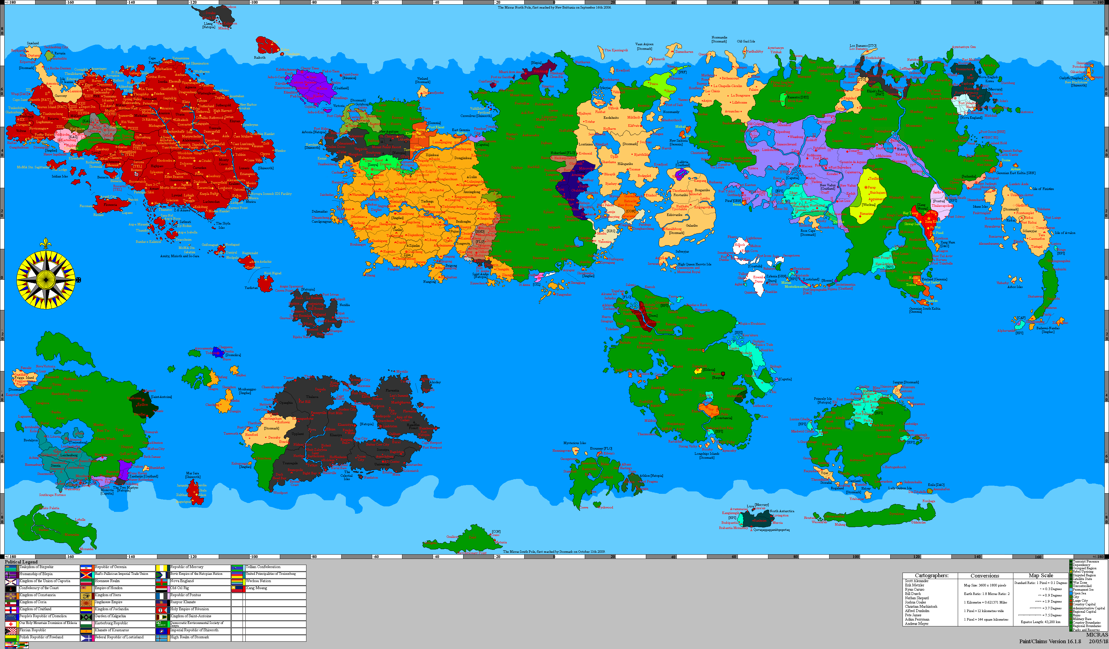
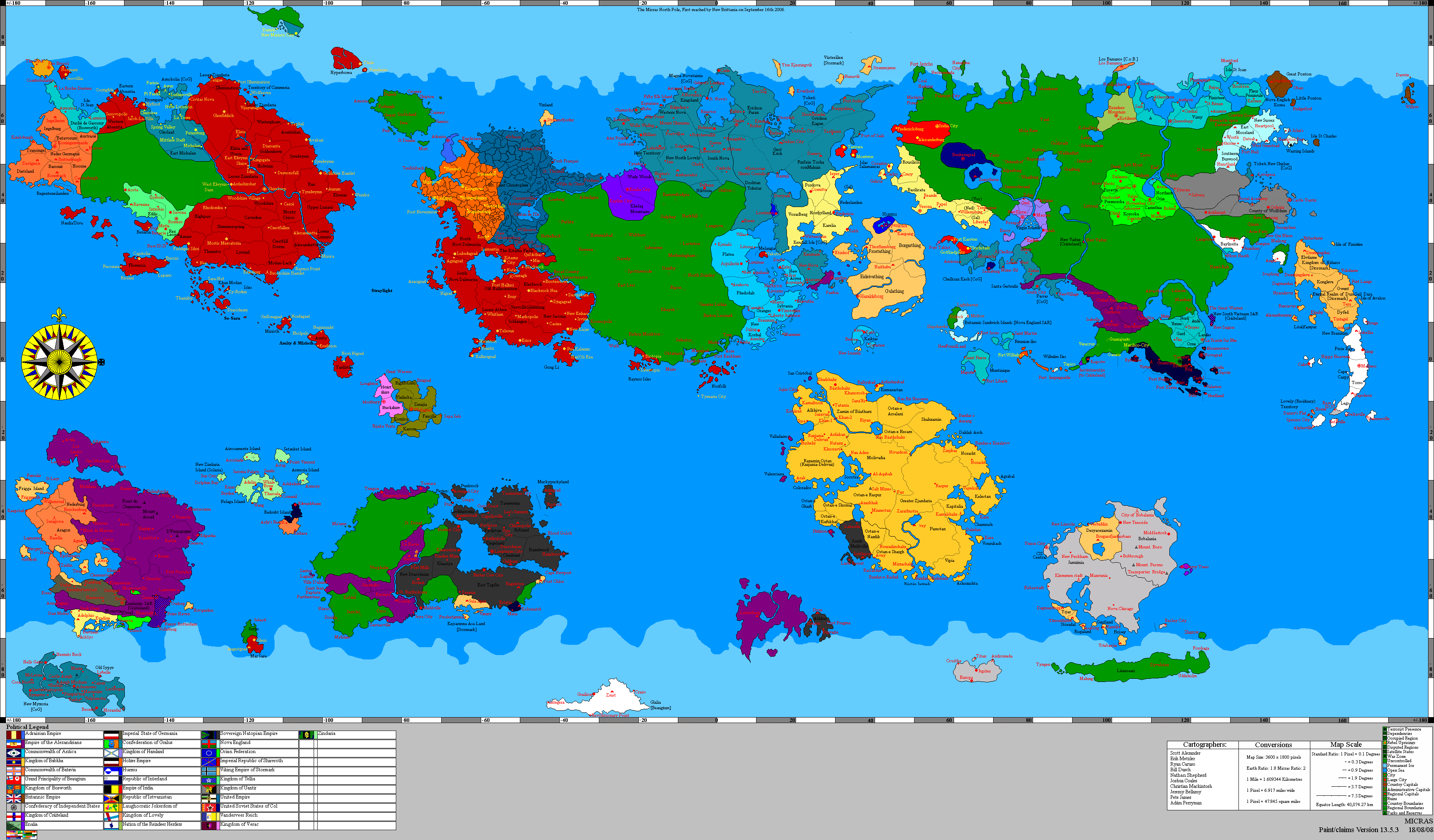
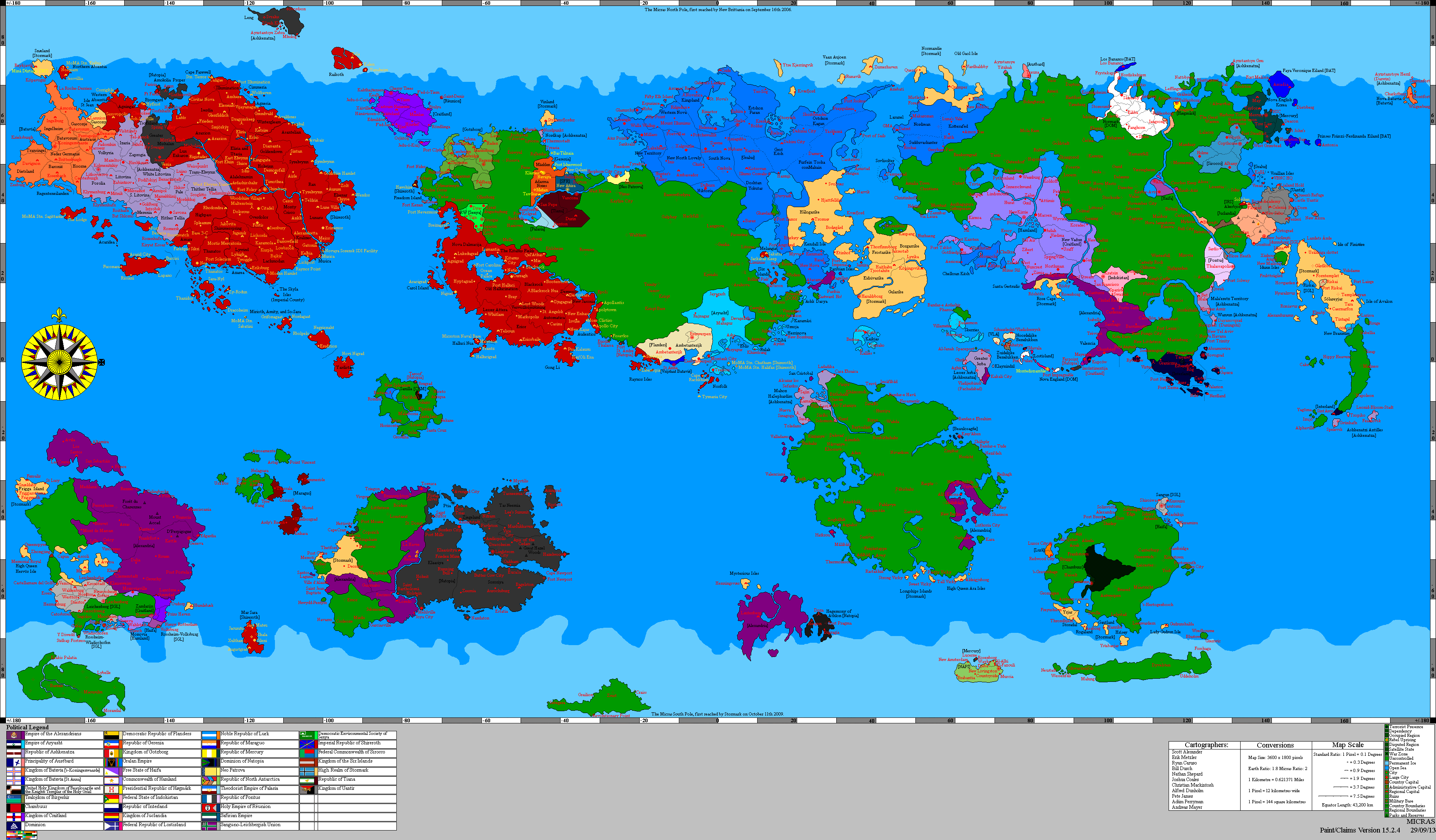
History
A region whose inhabitants are ethnically and culturally unique, the Passasian Unincorporated Territory is the traditional home of a self-governing community of indigenous Spanish-speaking Kralians who have lived and worked in the area since at least 14.61 PSSC. To that extent, the kralians of the Passasian Unincorporated Territory, whose lands have historically been claimed by nations including Passas, Gralus, Alexandria, Hamland, and Passio-Corum, represent one of the oldest communities in continuous existence anywhere in the eastern hemisphere. With that said, the cultural heritage of the region's inhabitants and their right to the land became the subject of scrutiny and controversy in 35.92 PSSC, when the Council of Courts of the Greater Pallisican Trade Association issued a decree which opened the region to potential settlement by people displaced by the Hammish Civil War.
Geography
Climate and Topography
| Climate V|Topography > | |||||
|---|---|---|---|---|---|
| Sea Level | Coastal Plains | High Plains | Highlands | Mountains | |
| Csb | X | X | |||
| Cwb | X | X | X | ||
| Cfa | X | X | |||
| Cfb | X | X | |||
| Cfc | X | X |
Demographics
Region Statistics
| Year | Population | Growth (Growth %) | Food Imports (/Person) | Fuel Imports (/Person) | Other Imports (/Person) | Immigration Modifier (%) | Seats in Regional Government | Seats in Houses of Corum
|
|---|---|---|---|---|---|---|---|---|
| 39.80 PSSC | 1,450,288 | -94,353 (-6.51%) | 2,489,709 (1.71) | 14,881,647 (10.26) | 3,347,046 (2.3) | .07 | 0 (self-governed) | 0 (self-governed) |
| 39.60 PSSC | 1,544,642 | -44,364 (-2.87%) | 2,261,254 (1.46) | 11,733,864 (7.59) | 3,167,571 (2.05) | .09 | 0 (self-governed) | 0 (self-governed) |
| 39.40 PSSC | 1,589,007 | -78,305 (-4.93%) | 2,480,758 (1.56) | 11,675,193 (7.34) | 3,499,688 (2.2) | .09 | 0 (self-governed) | 0 (self-governed) |
| 39.20 PSSC | 1,667,313 | 66,048 (3.96%) | 2,608,490 (1.56) | 12,219,177 (7.32) | 3,698,031 (2.21) | .09 | 0 (self-governed) | 0 (self-governed) |
| 39.00 PSSC | 1,601,265 | 25,102 (1.57%) | 2,095,087 (1.3) | 11,112,789 (6.95) | 2,787,783 (1.74) | .1 | 0 (self-governed) | 0 (self-governed) |
| 38.80 PSSC | 1,576,163 | -1,289 (-.08%) | 2,004,744 (1.27) | 12,291,789 (8.19) | 2,595,394 (1.64) | .09 | 0 (self-governed) | 0 (self-governed) |
| 38.60 PSSC | 1,577,453 | -21,219 (-1.35%) | 1,844,211 (1.16) | 10,285,452 (6.45) | 2,310,822 (1.46) | .11 | 0 (self-governed) | 0 (self-governed) |
| 38.40 PSSC | 1,598,673 | -51,134 (-3.2%) | 1,489,486 (.93) | 10,586,039 (6.62) | 1,457,872 (1.53) | .11 | 0 (self-governed) | 0 (self-governed) |
| 38.20 PSSC | 1,649,808 | -74,525 (-4.52%) | 1,735,410 (1.05) | 11,776,643 (7.13) | 2,986,036 (1.8) | .1 | 0 (self-governed) | 0 (self-governed) |
| 38.00 PSSC | 1,724,334 | 49,180 (2.85%) | 1,366,719 (.79) | 8,552,314 (4.95) | 2,397,638 (1.39) | .14 | 0 (self-governed) | 0 (self-governed) |
| 37.80 PSSC | 1,675,154 | 60,216 (3.59%) | 1,303,762 (.778) | 11,740,839 (7.00) | 2,184,075 (1.3) | .11 | 0 (self-governed) | 0 (self-governed) |
| 37.60 PSSC | 1,614,938 | 28,183 (1.75%) | 1,192,297 (.738) | 11,286,189 (6.988) | 2,202,772 (1.36) | .11 | 0 (self-governed) | 0 (self-governed) |
| 37.40 PSSC | 1,586,755 | 41,993 (2.65%) | 990,527 (.624) | 9,549,944 (6.01) | 1,660,603 (1.04) | .13 | 0 (self-governed) | 0 (self-governed) |
| 37.20 PSSC | 1,544,762 | 66,557 (4.31%) | 998,361 (.646) | 10,125,278 (6.55) | 1,745,124 (1.12) | .12 | 0 (self-governed) | 0 (self-governed) |
| 37.00 PSSC | 1,478,205 | 23,240 (1.57%) | 982.093 (.664) | 10,038,319 (6.79) | 1,239,992 (875) | .12 | 0 (self-governed) | 0 (self-governed) |
| 36.80 PSSC | 1,454,965 | -60,574 (-4.16%) | 1,36,734 (.918) | 1,965,509 (1.09) | 13,229,927 (9.09) | .09 | 0 (self-governed) | 0 (self-governed) |
| 36.60 PSSC | 1,515,540 | -29,344 (-1.94%) | 1,451,026 (.957) | 3,248,964 (2.143) | 1,198,971 (.755) | .09 | 0 (self-governed) | 0 (self-governed) |
| 36.20 PSSC | 1,544,885 | 26,381 (1.71%) | 1,373,933 (.88) | 1,357,125 (.87) | 1,136,842 (.75) | .1 | 0 (self-governed) | 0 (self-governed) |
| 36.00 PSSC | 1,518,504 | -20,252 (-1.33%) | 1,354,805 (.89) | 1,354,275 (.89) | 1,136,146 (.75) | .1 | 0 (self-governed) | 0 (self-governed) |
| 35.92 PSSC | 1,538,764 | - | 1,326,113 (.86) | 1,350,000 (.87) | 1,133,415 (.75) | .1 | 0 (self-governed) | 0 (self-governed) |
Transportation
Military Installations
Protected Areas
| |||||||||||