Gerenian Capital Territory
| Gerenian Capital Territory | |
|---|---|
| County of Gerenia | |
 |
|
| Nation | |
| Province | |
| Established | 2013 |
| Capital | Nevaya |
| Area | |
| • Total | 207 km2 (80 sq mi) |
| Area rank | 39th |
| Population (2018) | |
| • Total | 27,471 |
| • Rank | 35th |
| • Density | 132.71/km2 (343.7/sq mi) |
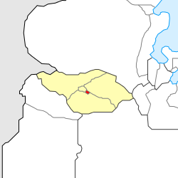
Gerenian Capital Territory (abbreviated GCT) is a county in the east of Gerenia, enclaved within Clements. It is the second smallest second-level subdivision in the country, behind Elerat Kad. The capital city and most populous community is the Klämen suburb of Nevaya, Gerenia's capital city.
Geography
The Gerenian Capital Territory is bounded by the Nevaya River in the north and the west, and by the former boundaries of Klämen in the east and the south.
Apart from the city of Nevaya, the Gerenian Capital Territory also contains agricultural land in the eastern zone.
History
The capital city of Gerenia since its foundation, has been the city of Klämen (formerly Clementsgrad and Clementsskad). However, the main government buildings were located in the modern suburb of Salnat. In early 2013, the Parliament of Gerenia approved the establishment of a federal district. The town of Nevaya was chosen as new seat of the government, and shortly afterwards underwent a period of modernisation. In August of the same year, the county was created, and its boundaries officially delimited.
| |||||||||||||||||||||||||||||||||||