Gerze (district): Difference between revisions
No edit summary |
mNo edit summary |
||
| Line 23: | Line 23: | ||
|area_total_km2 = 11,533 | |area_total_km2 = 11,533 | ||
|area_land_km2 = | |area_land_km2 = | ||
|area_rank = [[List of Gerenian districts and counties by land area|20th]] | |||
|elevation_m = | |elevation_m = | ||
|population_as_of = | |population_as_of = 2018 | ||
|population_total = | |population_total = 359,203 | ||
|population_rank = [[List of Gerenian districts and counties by population|4th]] | |population_rank = [[List of Gerenian districts and counties by population|4th]] | ||
|population_density_km2 = | |population_density_km2 = 31.15 | ||
|population_demonym = Gerzean | |population_demonym = Gerzean | ||
|timezone = | |timezone = | ||
Revision as of 14:13, 6 July 2018
| Gerze | |
|---|---|
| District of Gerenia | |
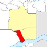
| Location within Sängeran | |
| Nation | |
| Province | |
| Established | 2012 |
| Capital | Gerze |
| Area | |
| • Total | 11,533 km2 (4,453 sq mi) |
| Area rank | 20th |
| Population (2018) | |
| • Total | 359,203 |
| • Rank | 4th |
| • Density | 31.15/km2 (80.7/sq mi) |
| Demonym | Gerzean |
Gerze is a district in Gerenia, located within Sängeran Province.
History
Gerze was founded in August 2012 as "Red River District", after the river that flows through the district. On 15 September of that year, Gerze's boundaries were officially determined, as the district was included in Sängeran, and its name was changed.
Within the district, the city of Gerze soon emerged as a very active port.
During the December Anarchy of 2013, Gerze remained relatively safe, thanks to the presence in the district (especially in the city of Gerze) of the Gerenian Armed Forces, whose headquarters are located near Mariaville. However, Gerze was not included in the government's project to retrieve the "Lost Lands", and thus it continued existing as an unrecognized claim.
Finally, in April 2014, the MCS decided to recognize Gerenian sovereignty over both Gerze and the Tawlkar District.
See also
| |||||||||||||||||||||||||||||||||||
