Ïeu'ryádoche District

|
This article or section is a work in progress. The information below may be incomplete, outdated, or subject to change. |
| Ïeu'ryádoche イェウリャドチェ |
|||||||||
|---|---|---|---|---|---|---|---|---|---|
| District of the Oriental Hispanioéire Taemhwan | |||||||||
| 1695 AN–1739 AN | |||||||||
| Ïeu'ryádoche District District d'Ïeu'ryádoche Daerah Ïeu'ryádoche イェウリャドチェ地区 |
|||||||||
| Sangunese transcription(s) | |||||||||
| • Katakana | イェウリャドチェ | ||||||||
| • Hiragana | いえうりゃどちぇ | ||||||||
| • Hepburn Rōmaji | I~euryadoche | ||||||||
| Other transcription(s) | |||||||||
| • Jawi | أيوءريادوشي | ||||||||
| • Simplified | 欧亚多奇 | ||||||||
| • Traditional | 歐亞多奇 | ||||||||
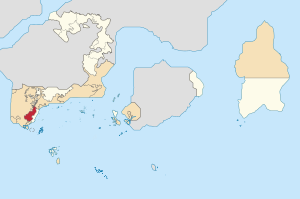
| Location of the Ïeu'ryádoche District (red) in the Oriental Hispanioéire Taemhwan | |||||||||
| Country | |||||||||
| SAT | |||||||||
| Capital | Saporok | ||||||||
| Districts | |||||||||
| Government | |||||||||
| • Governor | (vacant) | ||||||||
| • Governing body | Ïeu'ryádoche Regional Government | ||||||||
| • Executive | Executive Council (5) |
||||||||
| • Legislative | Grand Council (120) |
||||||||
| Area | |||||||||
| • Total | 1,345.96 km2 (519.68 sq mi) | ||||||||
| Highest elevation | 553 m (1,814 ft) | ||||||||
| Population (RP 2618) | |||||||||
| • Total | 215,491 | ||||||||
| • Density | 160/km2 (410/sq mi) | ||||||||
| Demonym | Ïeu'ryádochian[1] | ||||||||
| Demographics (RP 2618) | |||||||||
| • Ethnic groups | TBA | ||||||||
| • Official language | TBA | ||||||||
| • Dialects | TBA | ||||||||
| Time zone | PPT (UTC+5:20) | ||||||||
| Postcode | 106xxx | ||||||||
| Calling code | +6-04 | ||||||||
| Vehicle registration | CÏ | ||||||||
|
|||||||||
Ïeu'ryádoche (Sangunese: イェウリャドチェ, translit.: I~euryadoche?), officially the District of Ïeu'ryádoche (Sangunese: イェウリャドチェ地区, translit.: I~euryadoche Chiku?, French-Alexandrian: District d'Ïeu'ryádoche; Phineaner: Daerah Ïeu'ryádoche) or Province of Ïeu'ryádoche (Sangunese: イェウリャドチェ州, translit.: I~euryadoche Shū?, French-Alexandrian: Province d'Ïeu'ryadoche; Phineaner: Provinsi Ïeu'ryádoche), is former districts of the provinces of Oriental Hispanioéire Taemhwan located in the western Taemhwanian Mainlands. The district borders the territory of the Orange Free State to the west and north, the district of Héi'an to the east, Tanah Adélie district and territory of Orange Free State to the north, territory of Turku and Hōri to the northeast and the Federal Special Capital Territory to the south. The province is divided into two regions where the northern region is known as White Ïeu'ryádoche which speaks French-Alexandrian, and the southern region is known as Carpatho-Ïeu'ryádoche which speaks Phineaner and Sangunese. Its capital is Saporok, it is located in Carpatho-Ïeu'ryádoche region and 120 kilometers from Phinbellan national capital, Negara Awan, and this district has eleven communes.
The Ïeu'ryádoche district is the homeland of an ethnic group known as the Ïeu'ryádoches, which is an ethnic group native to this district. This district or province is also one of the two trilingual provinces in Oriental Hispanioéire Taemhwan after Rhodes and Karafuto Area, where French-Alexandrian, Phineaner and Sangunese are the official languages in this district.
Notes
- ^ Not to be confused with Ïeu'ryádoches, a native group in this region
