ESB Isle
| ESB Isle | |||
| |||
| Motto: Profit is an argument that outweighs all others | |||
| Anthem: Imperial Majesty File:Constancia anthem.ogg | |||

| |||
| Map versions | - Present | ||
| Capital | xxxx | ||
| Largest city | xxxx | ||
| Official language(s) | Constancian | ||
| Official religion(s) | |||
| Demonym | Gentleman/Lady of the Isle | ||
| - Adjective | Honorable One | ||
| Government | Constitutional Monarchy | ||
| - Basilinna | Esmeralda al-Osman | ||
| - The Resident | TBA | ||
| - Legislature | |||
| Establishment | 13.V.1738 | ||
| Area | |||
| Population | |||
| Currency | Imperial Stater | ||
| Calendar | |||
| Time zone(s) | |||
| Mains electricity | |||
| Driving side | |||
| Track gauge | |||
| National website | |||
| National forum | |||
| National animal | Falco pelegrinoides | ||
| National food | |||
| National drink | |||
| National tree | |||
| Abbreviation | CON | ||
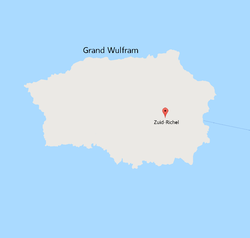
ESB Isle, the island formerly known as Grand Wulfram of the South Sea Islands, is located southeast of Corum. It is, officially and legally, a protectorate of the Imperial State of Constancia. Unofficially, it is an insidious den of avarice, fraud, iniquity, and various other unspeakables in polite company. It is a place of ill-repute, but of good corporate reputation.
History
The island, then known as Grand Wulfram, was incorporated into the territory of the South Sea Islands in 1553, and the city of Zuid-Richel was founded as a provisional capital. While Trinity Island was predominantly settled by Britannic Empire descendants from Madison Isles, Grand Wulfram's milder climate attracted settlers from more temperate areas of the former empire. As a result, Zuid-Richel rapidly became significantly more diverse, and expanded rapidly to become the South Sea Islands' largest settlement.
The Zuid-Richel Seaport was formally opened in 1560, South Seas International Aiport following in 1665. The presence of these key transport hubs have contributed to the city becoming the economic powerhouse of the South Sea Islands.
In 1737, the island's population was decimated by an outbreak of Southern Scurvy. The survivors, who totaled less than a thousand, were evacuated to Trinity Island and settled in to shelters at Joseph Town. At that point Zuid-Richel was officially abandoned by Moorland and the SSI.
Sensing a hostile takeover opportunity, on 13.V.1738, under the guise of a Razzia, elements of ESB-Jagdverbände, volunteers from the ESB Security Directorate based in Constancia, as well as other volunteers from Constancia, disembarked from the Admiral Deimos Jasonides, Ignatius-class amphibious transport dock vessel, to deploy and secure the otherwise-empty location, accompanied by KP Koudouras, a Logistic Support Vessel and Andronikos-class Auxiliary Cruisers Astyánax and KP Neoptolemos . Those embarked formed the Admiral Deimos Jasonides demi-regiment (for lack of a better name), of 5 moíra, with each moíra forming 3 kentarchia (troops) of 40 each. Each moíra had a specific mission:
- Moíra 1 and 2: Secure the former capital of Zuid-Richel
- Moíra 3 and 4: Secure the former South Seas International civilian airport
- Moíra 5: : Secure the seaport where the Admiral Deimos Jasonides would be docked when not reconnoitering the coastline
An extra kentarchia of Imperial Constancian Marines remained aboard the Admiral Deimos Jasonides as extra security.
The operation was executed without much incident, save for a volunteer that sprained their ankle while negotiating the ruins of Zuid-Richel, and another who was bitten by a rabid dog at the former South Seas International civilian airport, mere moments before the canine became a casualty of war by pistol fire.
Morning of the second day, 14.V.1738
Geography
The former city of Zuid-Richel, was located in south east of the island. Located on uplands several miles inland from the coast, the city enjoys a moderate climate with summer temperatures reaching a high off 22 degrees Celsius. The rural areas to the north and west are intensively cultivated for agriculture, while the south and east are typically dominated by volcanic rock. The highest point, formerly known as Mount Martinus, stands at 290 metres above sea level and can be seen from the city's western side.
The relatively mild climate of the island makes it an important agricultural region, which aids in self-sufficiency.
Economy
International Airport
Seaport
Railway Line
The former Bosworth Line is the only railway line, linking the city to the seaport via the interational airport.

