Equator: Difference between revisions
From MicrasWiki
Jump to navigationJump to search
| (7 intermediate revisions by 2 users not shown) | |||
| Line 1: | Line 1: | ||
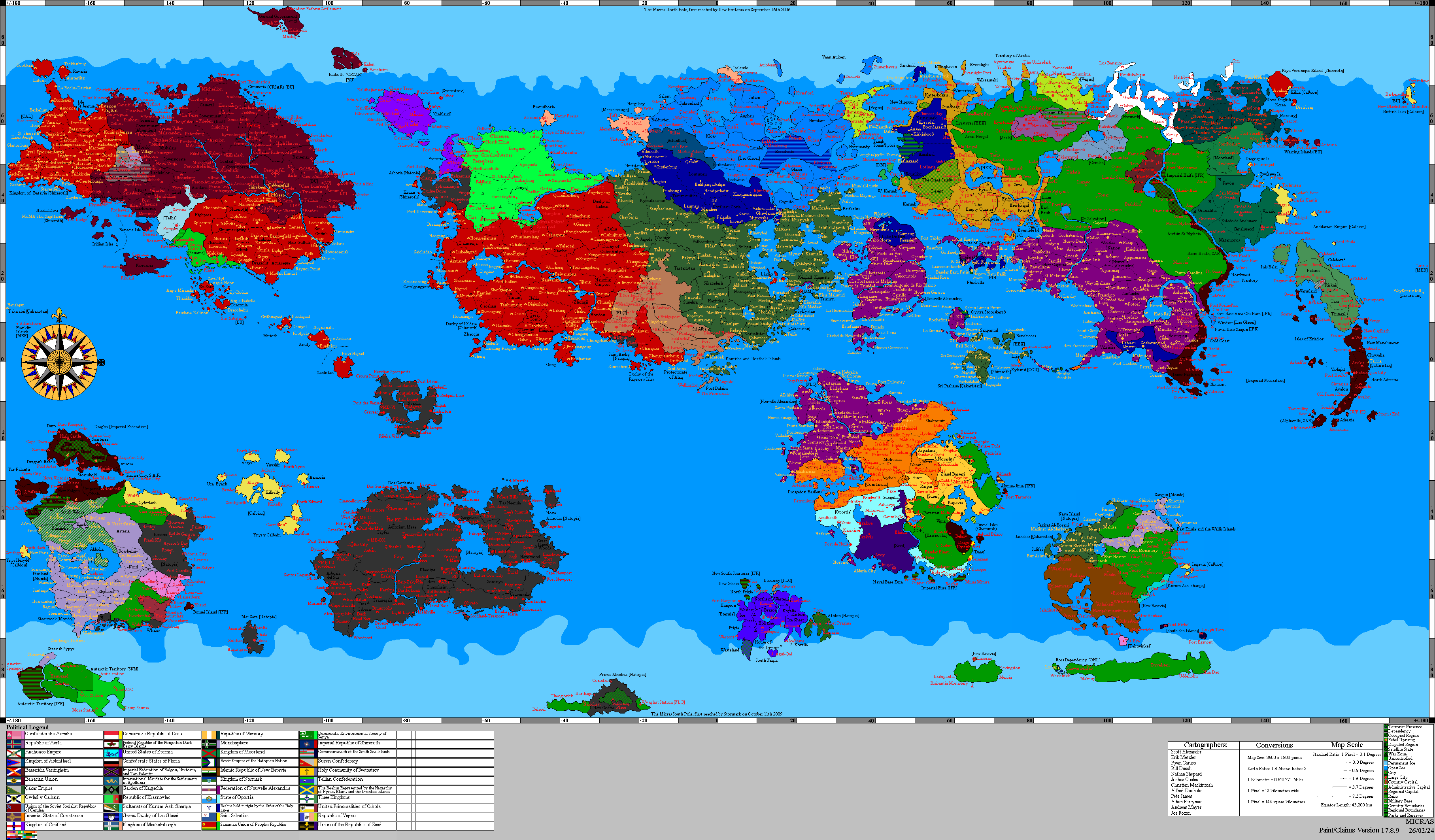
[[File:Micras Equator.png|450px|thumb|right|Equator on Micras]] | [[File:Micras Equator.png|450px|thumb|right|Equator on Micras]] | ||
The '''{{PAGENAME}}''' of [[Micras]] is the parallel halfway between the | [[File:Middlemicras.jpg|thumb|right|150px|The underwater monument 'Middle Micras', placed at the junction of the Prime Meridian and the Equator.]] | ||
The '''{{PAGENAME}}''' of [[Micras]] is the parallel halfway between the North and South Poles. The length of the equator is 43,200 km (3,600 pixels). The equator is measured from the [[Prime Meridian]] at ±0°E, with positive degrees (E) east and negative degrees (W) west. Those longitudinal lines meet again at the opposite side of the world, the Anti-Meridian, at ±180°W. | |||
== List of passages == | == List of passages == | ||
=== Longitudes east === | |||
On Micras, starting at the [[Prime Meridian]] heading east, the equator (according to claimsmap 17.6.1) passes through: | On Micras, starting at the [[Prime Meridian]] heading east, the equator (according to claimsmap 17.6.1) passes through: | ||
| Line 11: | Line 13: | ||
! scope="col" | Details | ! scope="col" | Details | ||
|- | |- | ||
|0. | | style="background:#b0e0e6;" |0.0°W | ||
| style="background:#b0e0e6;" | North Raynor Sea | | style="background:#b0e0e6;" | North Raynor Sea | ||
| style="background:#b0e0e6;" | [[Prime Meridian]] | | style="background:#b0e0e6;" | [[Prime Meridian]] | ||
| Line 19: | Line 21: | ||
| [[Kantisha and Northak Islands]] | | [[Kantisha and Northak Islands]] | ||
|- | |- | ||
|3.0°E | | style="background:#b0e0e6;" |3.0°E | ||
| style="background:#b0e0e6;" | North Raynor Sea | | style="background:#b0e0e6;" | North Raynor Sea | ||
| style="background:#b0e0e6;" | | | style="background:#b0e0e6;" | | ||
|- | |- | ||
| | | style="background:#b0e0e6;" | | ||
| style="background:#b0e0e6;" | Dyre Straits | | style="background:#b0e0e6;" | [[Dyre Straits]] | ||
| style="background:#b0e0e6;" | | | style="background:#b0e0e6;" | | ||
|- | |- | ||
| | | style="background:#b0e0e6;" | | ||
| style="background:#b0e0e6;" | Orange Sea | | style="background:#b0e0e6;" | [[Orange Sea]] | ||
| style="background:#b0e0e6;" | | | style="background:#b0e0e6;" | | ||
|- | |- | ||
|61.9°E | |61.9°E | ||
| {{Team flag|Çakaristan}} | | {{Team flag|Çakaristan}} | ||
| | | [[Sri Pashana]] | ||
|- | |- | ||
|63.5°E | | style="background:#b0e0e6;" |63.5°E | ||
| style="background:#b0e0e6;" | Orange Sea | | style="background:#b0e0e6;" | [[Orange Sea]] | ||
| style="background:#b0e0e6;" | | | style="background:#b0e0e6;" | | ||
|- | |- | ||
|64.1°E | |64.1°E | ||
| {{Team flag|Çakaristan}} | | {{Team flag|Çakaristan}} | ||
| | | [[Sri Pashana]] | ||
|- | |- | ||
|69.2°E | | style="background:#b0e0e6;" |69.2°E | ||
| style="background:#b0e0e6;" | [[Sea of Storms]] | | style="background:#b0e0e6;" | [[Sea of Storms]] | ||
| style="background:#b0e0e6;" | | | style="background:#b0e0e6;" | | ||
| Line 51: | Line 53: | ||
| | | | ||
|- | |- | ||
|76.7°E | | style="background:#b0e0e6;" |76.7°E | ||
| style="background:#b0e0e6;" | [[Sea of Storms]] | | style="background:#b0e0e6;" | [[Sea of Storms]] | ||
| style="background:#b0e0e6;" | | | style="background:#b0e0e6;" | | ||
|- | |- | ||
|80.1°E | |80.1°E | ||
| {{Team flag| | | {{Team flag|Nouvelle Alexandrie}} | ||
| | | | ||
|- | |- | ||
|80.6°E | | style="background:#b0e0e6;" |80.6°E | ||
| style="background:#b0e0e6;" | [[Captive Sea]] | | style="background:#b0e0e6;" | [[Captive Sea]] | ||
| style="background:#b0e0e6;" | | | style="background:#b0e0e6;" | | ||
| Line 67: | Line 69: | ||
| | | | ||
|- | |- | ||
|94.3°E | | style="background:#b0e0e6;" |94.3°E | ||
| style="background:#b0e0e6;" | [[Sea of Storms]] | | style="background:#b0e0e6;" | [[Sea of Storms]] | ||
| style="background:#b0e0e6;" | | | style="background:#b0e0e6;" | | ||
| Line 75: | Line 77: | ||
| | | | ||
|- | |- | ||
|106.6°E | | style="background:#b0e0e6;" |106.6°E | ||
| style="background:#b0e0e6;" | [[Sea of Storms]] | | style="background:#b0e0e6;" | [[Sea of Storms]] | ||
| style="background:#b0e0e6;" | | | style="background:#b0e0e6;" | | ||
| Line 84: | Line 86: | ||
|- | |- | ||
|111.0°E | |111.0°E | ||
| {{Team flag| | | {{Team flag|Hurmu}} | ||
| [[Tanah Baharu]], {{Team flag|Phinbella}} | | [[Tanah Baharu]], {{Team flag|Phinbella}} | ||
|- | |- | ||
| Line 95: | Line 97: | ||
|Inner Nixtorm | |Inner Nixtorm | ||
|- | |- | ||
|120.0°E | | style="background:#b0e0e6;" |120.0°E | ||
|Eastern Ocean | | style="background:#b0e0e6;" |Eastern Ocean | ||
| | | style="background:#b0e0e6;" | | ||
|- | |- | ||
|149.8°E | |149.8°E | ||
| Line 103: | Line 105: | ||
|Isles of Eriad'or | |Isles of Eriad'or | ||
|- | |- | ||
|151.5°E | | style="background:#b0e0e6;" |151.5°E | ||
|Eastern Ocean | | style="background:#b0e0e6;" |Eastern Ocean | ||
| | | style="background:#b0e0e6;" | | ||
|- | |- | ||
|152.1°E | |152.1°E | ||
| Line 111: | Line 113: | ||
|Isles of Eriad'or | |Isles of Eriad'or | ||
|- | |- | ||
|152.9°E | | style="background:#b0e0e6;" |152.9°E | ||
|Eastern Ocean | | style="background:#b0e0e6;" |Eastern Ocean | ||
| | | style="background:#b0e0e6;" | | ||
|- | |- | ||
|159.8°E | |159.8°E | ||
| Line 120: | Line 122: | ||
|- | |- | ||
|161.3°E | |161.3°E | ||
|{{Team flag|Imperial Federation}} | |||
|North Adrestia | |North Adrestia | ||
|- | |- | ||
|164.5°E | |164.5°E | ||
|Tarria | |{{Team flag|Çakaristan}} | ||
|[[Tarria]] | |||
|- | |||
| style="background:#b0e0e6;" |164.9°E | |||
| style="background:#b0e0e6;" rowspan="2" |[[Great Western Sea]] | |||
| style="background:#b0e0e6;" | | |||
|- | |- | ||
| | | style="background:#b0e0e6;" |180.0°E | ||
| | | style="background:#b0e0e6;" | [[Prime Meridian|Anti-Meridian]] | ||
| | |} | ||
=== Longitudes west === | |||
On Micras, starting at the Anti-Meridian heading east, the equator (according to claimsmap 17.6.1) passes through: | |||
{| class="wikitable plainrowheaders" | |||
!Approx. long. | |||
! scope="col" | Country, territory or sea | |||
! scope="col" | Details | |||
|- | |- | ||
|180. | | style="background:#b0e0e6;" |180.0°E | ||
|[[Great Western Sea]] | |||
| style="background:#b0e0e6;" | [[Prime Meridian|Anti-Meridian]] | | style="background:#b0e0e6;" | [[Prime Meridian|Anti-Meridian]] | ||
|- | |- | ||
| | |97.1°W | ||
| {{Team flag|Shireroth}} | | rowspan="2" | {{Team flag|Shireroth}} | ||
| | |[[Yardistan]], {{Team flag|Sathrati}} | ||
|- | |||
|94.9°W | |||
|Novi Nigrad, [[Yardistan]], {{Team flag|Sathrati}} | |||
|- | |- | ||
| | | style="background:#b0e0e6;" |92.4°W | ||
| style="background:#b0e0e6;" | Central Sea | | style="background:#b0e0e6;" | Central Sea | ||
| style="background:#b0e0e6;" | | | style="background:#b0e0e6;" | | ||
|- | |- | ||
| | | | ||
|North Raynor Sea | |||
| | |||
|- | |||
|40.6°W | |||
| {{Team flag|Shireroth}} | | {{Team flag|Shireroth}} | ||
| | |Gong, [[Greater Kildare]] | ||
|- | |- | ||
| | |40.0°W | ||
| style="background:#b0e0e6;" | | | style="background:#b0e0e6;" | North Raynor Sea | ||
| style="background:#b0e0e6;" | | | style="background:#b0e0e6;" | | ||
|- | |- | ||
| | |39.5°W | ||
| {{Team flag|Shireroth}} | | {{Team flag|Shireroth}} | ||
| | |Gong, [[Greater Kildare]] | ||
|- | |- | ||
| | |38.8°W | ||
| style="background:#b0e0e6;" |North Raynor Sea | |||
| style="background:#b0e0e6;" | | | style="background:#b0e0e6;" | | ||
|- | |||
|38.7°W | |||
| {{Team flag|Shireroth}} | |||
|Gong, [[Greater Kildare]] | |||
|- | |||
|36.2°W | |||
| style="background:#b0e0e6;" |North Raynor Sea | |||
| style="background:#b0e0e6;" | | | style="background:#b0e0e6;" | | ||
|- | |- | ||
| | |35.8°W | ||
| {{Team flag|Shireroth}} | |||
|Gong, [[Greater Kildare]] | |||
|- | |||
|35.3°W | |||
| style="background:#b0e0e6;" |North Raynor Sea | |||
| style="background:#b0e0e6;" |Carama Bay | |||
|- | |||
|21.9°W | |||
| {{Team flag|Shireroth}} | | {{Team flag|Shireroth}} | ||
| | |[[Duke of Raynor's Isles|Duchy of the Raynor's Isles]] | ||
|- | |- | ||
| | |20.9°W | ||
| style="background:#b0e0e6;" | | | style="background:#b0e0e6;" |North Raynor Sea | ||
| style="background:#b0e0e6;" | | | style="background:#b0e0e6;" | | ||
|- | |- | ||
|20.2°W | |||
|{{Team flag|Shireroth}} | |||
|[[Duke of Raynor's Isles|Duchy of the Raynor's Isles]] | |||
|- | |||
|20.1°W | |||
|North Raynor Sea | |||
| | | | ||
| {{Team flag|Shireroth}} | |- | ||
|17.5°W | |||
|{{Team flag|Shireroth}} | |||
|[[Duke of Raynor's Isles|Duchy of the Raynor's Isles]] | |||
|- | |||
|16.9°W | |||
|North Raynor Sea | |||
| | | | ||
|- | |- | ||
|16.8°W | |||
|{{Team flag|Shireroth}} | |||
|[[Duke of Raynor's Isles|Duchy of the Raynor's Isles]] | |||
|- | |||
|16.5°W | |||
|North Raynor Sea | |||
| | | | ||
|- | |- | ||
|16.2°W | |||
|{{Team flag|Shireroth}} | |||
|[[Duke of Raynor's Isles|Duchy of the Raynor's Isles]] | |||
|- | |||
|14.3°W | |||
|North Raynor Sea | |||
| | | | ||
|- | |- | ||
|13.4°W | |||
|{{Team flag|Shireroth}} | |||
|{{Team flag|Alrig}} | |||
|- | |||
|9.9°W | |||
|North Raynor Sea | |||
| | | | ||
|- | |- | ||
| | | | ||
| {{team flag|Floria}} | |{{team flag|Floria}} | ||
| | |''Unknown'' | ||
|- | |- | ||
| | | | ||
| Line 192: | Line 253: | ||
| | | | ||
| {{Team flag|Çakaristan}} | | {{Team flag|Çakaristan}} | ||
| | |[[Kantisha and Northak Islands]] | ||
|- | |- | ||
| | | | ||
| style="background:#b0e0e6;" | North Raynor Sea | | style="background:#b0e0e6;" | North Raynor Sea | ||
| style="background:#b0e0e6;" | | | style="background:#b0e0e6;" | | ||
|- | |||
|0.0°W | |||
|North Raynor Sea | |||
|[[Prime Meridian]] | |||
|} | |} | ||
Trivia | == Trivia == | ||
* The equator only passes through the three northern continents, but none of the four southern continents. | * The equator only passes through the three northern continents, but none of the four southern continents. | ||
[[Category:Micras]] | [[Category:Micras]] | ||
[[Category:Geography]] | [[Category:Geography]] | ||
Latest revision as of 10:57, 2 January 2024


The Equator of Micras is the parallel halfway between the North and South Poles. The length of the equator is 43,200 km (3,600 pixels). The equator is measured from the Prime Meridian at ±0°E, with positive degrees (E) east and negative degrees (W) west. Those longitudinal lines meet again at the opposite side of the world, the Anti-Meridian, at ±180°W.
List of passages
Longitudes east
On Micras, starting at the Prime Meridian heading east, the equator (according to claimsmap 17.6.1) passes through:
| Approx. long. | Country, territory or sea | Details |
|---|---|---|
| 0.0°W | North Raynor Sea | Prime Meridian |
| 2.7°E |  Çakaristan |
Kantisha and Northak Islands |
| 3.0°E | North Raynor Sea | |
| Dyre Straits | ||
| Orange Sea | ||
| 61.9°E | Çakaristan
|
Sri Pashana |
| 63.5°E | Orange Sea | |
| 64.1°E | Çakaristan
|
Sri Pashana |
| 69.2°E | Sea of Storms | |
| 76.0°E |  Constancia |
|
| 76.7°E | Sea of Storms | |
| 80.1°E |  Nouvelle Alexandrie |
|
| 80.6°E | Captive Sea | |
| 92.0°E | Nouvelle Alexandrie
|
|
| 94.3°E | Sea of Storms | |
| 105.9°E | Nouvelle Alexandrie
|
|
| 106.6°E | Sea of Storms | |
| 109.5°E | Nouvelle Alexandrie
|
|
| 111.0°E |  Hurmu |
Tanah Baharu,  Phinbella |
| 111.1°E | Nouvelle Alexandrie
|
|
| 113.9°E |  Imperial Federation |
Inner Nixtorm |
| 120.0°E | Eastern Ocean | |
| 149.8°E | Imperial Federation
|
Isles of Eriad'or |
| 151.5°E | Eastern Ocean | |
| 152.1°E | Imperial Federation
|
Isles of Eriad'or |
| 152.9°E | Eastern Ocean | |
| 159.8°E | Imperial Federation
|
Violight |
| 161.3°E | Imperial Federation
|
North Adrestia |
| 164.5°E | Çakaristan
|
Tarria |
| 164.9°E | Great Western Sea | |
| 180.0°E | Anti-Meridian |
Longitudes west
On Micras, starting at the Anti-Meridian heading east, the equator (according to claimsmap 17.6.1) passes through:
| Approx. long. | Country, territory or sea | Details |
|---|---|---|
| 180.0°E | Great Western Sea | Anti-Meridian |
| 97.1°W |  Shireroth |
Yardistan,  Sathrati |
| 94.9°W | Novi Nigrad, Yardistan, Sathrati
| |
| 92.4°W | Central Sea | |
| North Raynor Sea | ||
| 40.6°W | Shireroth
|
Gong, Greater Kildare |
| 40.0°W | North Raynor Sea | |
| 39.5°W | Shireroth
|
Gong, Greater Kildare |
| 38.8°W | North Raynor Sea | |
| 38.7°W | Shireroth
|
Gong, Greater Kildare |
| 36.2°W | North Raynor Sea | |
| 35.8°W | Shireroth
|
Gong, Greater Kildare |
| 35.3°W | North Raynor Sea | Carama Bay |
| 21.9°W | Shireroth
|
Duchy of the Raynor's Isles |
| 20.9°W | North Raynor Sea | |
| 20.2°W | Shireroth
|
Duchy of the Raynor's Isles |
| 20.1°W | North Raynor Sea | |
| 17.5°W | Shireroth
|
Duchy of the Raynor's Isles |
| 16.9°W | North Raynor Sea | |
| 16.8°W | Shireroth
|
Duchy of the Raynor's Isles |
| 16.5°W | North Raynor Sea | |
| 16.2°W | Shireroth
|
Duchy of the Raynor's Isles |
| 14.3°W | North Raynor Sea | |
| 13.4°W | Shireroth
|
 Alrig |
| 9.9°W | North Raynor Sea | |
 Floria |
Unknown | |
| North Raynor Sea | ||
| Çakaristan
|
Kantisha and Northak Islands | |
| North Raynor Sea | ||
| 0.0°W | North Raynor Sea | Prime Meridian |
Trivia
- The equator only passes through the three northern continents, but none of the four southern continents.