Erisland: Difference between revisions
From MicrasWiki
Jump to navigationJump to search
(Created page with "{| class="infobox vcard geography" style="width:300px; font-size:83%;" | colspan="2" style="text-align:center;" | <big>'''Erisland'''</big><br><br><big>'''''Erislen''' </big>(...") |
mNo edit summary |
||
| (5 intermediate revisions by the same user not shown) | |||
| Line 1: | Line 1: | ||
{| | {{Infobox settlement | ||
| | |official_name = Erisland | ||
| | |native_name = ''Erislen ([[Gerenian language|gn]])'' | ||
|settlement_type = [[:Category:Dependencies of Gerenia|Dependency]] of [[Gerenia]] | |||
|image_caption = | |||
|image_flag = Erisland flag.png | |||
| | |image_seal = Erisland seal.png | ||
|seal_size = 75px | |||
| | |motto = ''Snirettät, Relkettät, Sehinet''<br>''(Unity, Prosperity, Solidarity)'' | ||
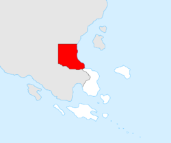
|image_map = Location of Erisland.png | |||
| | |mapsize = 250px | ||
| | |map_caption = Location within southern [[Keltia]] | ||
| | |subdivision_type = Nation | ||
| | |subdivision_name = {{team flag|Gerenia}} | ||
| | |established_title = Established | ||
| | |established_date = 3 March 2018 | ||
| | |seat_type = [[Capital]] | ||
| | |seat = [[Natski]] | ||
|government_type = | |||
|leader_title = Governor | |||
|leader_name = [[Daniel Kásteres]] | |||
| | |leader_party = | ||
| | |area_magnitude = | ||
| | |area_total_km2 = 124,557 | ||
| | |area_land_km2 = | ||
| | |elevation_m = | ||
| | |population_as_of = 2018 | ||
| | |population_total = 105,574 | ||
| | |population_rank = | ||
| | |population_density_km2 = 0.85 | ||
|population_demonym = Erislander | |||
|timezone = | |||
|utc_offset = | |||
|timezone_DST = | |||
|utc_offset_DST = | |||
}} | |||
'''Erisland''' is a [[Gerenia]]n [[wikipedia:Dependent territory|dependency]] located in south-east [[Keltia]], north of [[Gerenian South Keltia]]. | '''Erisland''' is a [[Gerenia]]n [[wikipedia:Dependent territory|dependency]] located in south-east [[Keltia]], north of [[Gerenian South Keltia]]. | ||
Erisland was founded in March 2018 after several months of development, in which the natives of the region cooperated with the [[Gerenian pioneer]]s. | Erisland was founded in March 2018 after several months of development, in which the natives of the region cooperated with the [[Gerenian pioneer]]s. | ||
==Geography== | |||
Most of Erisland's territory belongs to the coastal plains of southern Keltia. The south and west parts of the territory are a hilly landscape, which continue in the mountains of Gerenian South Keltia. The highest peak in Erisland is the Lezare (1,254 m). | |||
Several long rivers flow through the plain into the [[Eastern Ocean]], the major being the Apertere, the Vesat, and the Ryh. River Scyne forms the border with Gerenian South Keltia. | |||
{{Administrative divisions of Gerenia}} | |||
[[Category:Dependencies of Gerenia]] | [[Category:Dependencies of Gerenia]] | ||
Latest revision as of 17:09, 25 August 2018
| Erisland Erislen (gn) |
|||
|---|---|---|---|
| Dependency of Gerenia | |||
|
|||
| Motto: Snirettät, Relkettät, Sehinet (Unity, Prosperity, Solidarity) |
|||
| Location within southern Keltia | |||
| Nation | |||
| Established | 3 March 2018 | ||
| Capital | Natski | ||
| Government | |||
| • Governor | Daniel Kásteres | ||
| Area | |||
| • Total | 124,557 km2 (48,092 sq mi) | ||
| Population (2018) | |||
| • Total | 105,574 | ||
| • Density | 0.85/km2 (2.2/sq mi) | ||
| Demonym | Erislander | ||
Erisland is a Gerenian dependency located in south-east Keltia, north of Gerenian South Keltia.
Erisland was founded in March 2018 after several months of development, in which the natives of the region cooperated with the Gerenian pioneers.
Geography
Most of Erisland's territory belongs to the coastal plains of southern Keltia. The south and west parts of the territory are a hilly landscape, which continue in the mountains of Gerenian South Keltia. The highest peak in Erisland is the Lezare (1,254 m).
Several long rivers flow through the plain into the Eastern Ocean, the major being the Apertere, the Vesat, and the Ryh. River Scyne forms the border with Gerenian South Keltia.
| |||||||||||||||||


