Sängeran: Difference between revisions
mNo edit summary |
mNo edit summary |
||
| Line 21: | Line 21: | ||
|leader_party = | |leader_party = | ||
|area_magnitude = | |area_magnitude = | ||
|area_total_km2 = | |area_total_km2 = 155,375 | ||
|area_land_km2 = | |area_land_km2 = | ||
|area_rank = 1st | |area_rank = 1st | ||
| Line 28: | Line 28: | ||
|population_total = 925,555 | |population_total = 925,555 | ||
|population_rank = 4th | |population_rank = 4th | ||
|population_density_km2 = | |population_density_km2 = 5.96 | ||
|population_demonym = Sänger | |population_demonym = Sänger | ||
|timezone = | |timezone = | ||
Revision as of 17:26, 25 August 2018
| Sängeran | |||
|---|---|---|---|
| Province of Gerenia | |||
|
|||
 |
|||
| Nation | |||
| Established | 14 August 2012 | ||
| Capital | Gerze | ||
| Government | |||
| • Governor | Ferant Udere (IPG) | ||
| Area | |||
| • Total | 155,375 km2 (59,991 sq mi) | ||
| Area rank | 1st | ||
| Population (2018) | |||
| • Total | 925,555 | ||
| • Rank | 4th | ||
| • Density | 5.96/km2 (15.4/sq mi) | ||
| Demonym | Sänger | ||
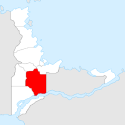
Sängeran is a province in Gerenia. The province borders the Camoleo to the south, Adarma to the southwest, the Western province to the west, Clements and Barzat to the north, and Jingdao to the east. Sängeran is the largest province of Gerenia.
Etymology
The name Sängeran is believed to come from Gerenian word siehn, which means "bone". Early Gerenian settlers have documented they found large amounts of bones in various locations, especially along the Red River. Such bones belonged to human beings as well as to animals. The word siehn may have been suffered changes through the years.
Geography
The territory of Sängeran belongs of two geographical regions: the Ark Plain, and the Samarne Plateau. The Ark Plain, in the north, is a wooded region. The only major settlement in the area is Gentóul. The Plain transitions to the Plateau region in southern Sängeran. The Samarne Plateau is the province's most densely populated section. It consists of gently rolling countryside frequently broken by hills or low mountain ridges. Small, isolated, and deeply eroded mountain ranges and peaks are located in the Plateau.
Demographics
With a population of nearly 895,000 as of 2017, Sängeran is the fourth province by population in Gerenia. Roughly 40% of the province's population lives along the Red River. Two of the biggest cities (Gerze and Mariaville) are located in the zone. Other major cities are Gentóul in the north-west, and Pilakil, in the south-east.
History
The first Gerenians to arrive at the area chose to settle in the confluence of the Camoleo and the Red River. In such location, in August 2012, Gerze was founded. Shortly afterwards, the Sängeran province was created, following the issuance of a Subdivisional Charter. However, the subdivisions of Sängeran were not delimited until November. By early 2013, some other cities (Gentóul, Pilakil, Inevare, Enkurs) had been founded.
See also
| |||||

