West: Difference between revisions
From MicrasWiki
Jump to navigationJump to search
(Created page with "{| class="infobox vcard geography" style="width:300px; font-size:83%;" | colspan="2" style="text-align:center;" | <big>'''Western Province'''</big><br><br>'''''Proziu Västere...") |
mNo edit summary |
||
| (9 intermediate revisions by the same user not shown) | |||
| Line 1: | Line 1: | ||
{| | {{Infobox settlement | ||
| | |official_name = West | ||
| | |native_name = ''Väster ([[Gerenian language|gn]])'' | ||
|settlement_type = [[Provinces of Gerenia|Province]] of [[Gerenia]] | |||
|image_caption = | |||
| | |image_flag = West flag.png | ||
| | |image_seal = West coa.png | ||
| | |seal_size = 75px | ||
|image_map = West in Gerenia.png | |||
| | |mapsize = 250px | ||
| | |map_caption = Location within [[Mainland Gerenia]] | ||
| | |subdivision_type = Nation | ||
| | |subdivision_name = {{team flag|Gerenia}} | ||
| | |established_title = Established | ||
| | |established_date = 14 August 2012 | ||
| | |seat_type = [[Capital]] | ||
| | |seat = [[Baraŷa]] | ||
| | |government_type = | ||
| | |leader_title = Governor | ||
| | |leader_name = [[Karl Sertate]] ([[Socialist Party of Gerenia|SPG]]) | ||
| | |leader_party = | ||
| | |area_magnitude = | ||
| | |area_total_km2 = 78,662 | ||
| | |area_land_km2 = | ||
| | |area_rank = 6th | ||
| | |elevation_m = | ||
| | |population_as_of = 2018 | ||
| | |population_total = 305,896 | ||
| | |population_rank = 8th | ||
| | |population_density_km2 = 3.89 | ||
|population_demonym = Westerner | |||
'''West''' ([[Gerenian language|Gerenian]]: ''Väster'', pronunciation ['vez.tər]) is a [[ | |timezone = | ||
|utc_offset = | |||
|timezone_DST = | |||
|utc_offset_DST = | |||
}} | |||
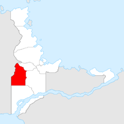
'''West''' ([[Gerenian language|Gerenian]]: ''Väster'', pronunciation ['vez.tər]) is a [[Provinces of Gerenia|province]] of [[Gerenia]]. | |||
The Western Province borders [[Clements]] to the north, [[Sängeran]] to the east, [[Adarma]] to the south, and unclaimed territory to the west. Major settlements in the province include the capital, [[Baraŷa]], Eget, and Zardevat. | The Western Province borders [[Clements]] to the north, [[Sängeran]] to the east, [[Adarma]] to the south, [[New Aquitane]] to the south-west, and unclaimed territory to the west. Major settlements in the province include the capital, [[Baraŷa]], [[Eget]], and Zardevat. | ||
Created in 2012, West lies on two hilly formations: the Sawes Plateau to the south, and the Króuvița Heights to the north. Small quantities of [[wikipedia:Natural gas|natural gas]] and minerals are extracted from the hills. | Created in 2012, West lies on two hilly formations: the Sawes Plateau to the south, and the Króuvița Heights to the north. Small quantities of [[wikipedia:Natural gas|natural gas]] and minerals are extracted from the hills. | ||
Latest revision as of 17:27, 25 August 2018
| West Väster (gn) |
|||
|---|---|---|---|
| Province of Gerenia | |||
|
|||
| Location within Mainland Gerenia | |||
| Nation | |||
| Established | 14 August 2012 | ||
| Capital | Baraŷa | ||
| Government | |||
| • Governor | Karl Sertate (SPG) | ||
| Area | |||
| • Total | 78,662 km2 (30,372 sq mi) | ||
| Area rank | 6th | ||
| Population (2018) | |||
| • Total | 305,896 | ||
| • Rank | 8th | ||
| • Density | 3.89/km2 (10.1/sq mi) | ||
| Demonym | Westerner | ||
West (Gerenian: Väster, pronunciation ['vez.tər]) is a province of Gerenia.
The Western Province borders Clements to the north, Sängeran to the east, Adarma to the south, New Aquitane to the south-west, and unclaimed territory to the west. Major settlements in the province include the capital, Baraŷa, Eget, and Zardevat.
Created in 2012, West lies on two hilly formations: the Sawes Plateau to the south, and the Króuvița Heights to the north. Small quantities of natural gas and minerals are extracted from the hills.
| |||||


