Norfolk Isles: Difference between revisions
No edit summary |
|||
| (2 intermediate revisions by the same user not shown) | |||
| Line 36: | Line 36: | ||
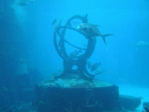
[[File:Middlemicras.jpg|thumb|right|The underwater monument 'Middle Micras']] | [[File:Middlemicras.jpg|thumb|right|The underwater monument 'Middle Micras']] | ||
After taking over territory in 1706 and 1711 AN from Thracistan, Çakaristan developed the northern islands, along with the island of Kantisha, into the state of [[Kantisha and Northak Islands]]. The former capital of Thracistan, [[Kadim]] remained a separate sarkar (district). The intersection of the Equator and Prime Meridian lies between the northern islands. This is marked with an underwater monument 'Middle Micras'. | After taking over territory in 1706 and 1711 AN from Thracistan, Çakaristan developed the northern islands, along with the island of Kantisha, into the state of [[Kantisha and Northak Islands]]. The former capital of Thracistan, [[Kadim]] remained a separate sarkar (district). The intersection of the Equator and Prime Meridian lies between the northern islands. This is marked with an underwater monument 'Middle Micras'. | ||
==Maps== | ==Maps== | ||
| Line 47: | Line 45: | ||
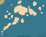
Image:Norfolkcommandsmap.png|The seven Commands of Norfolk in Shirerian times | Image:Norfolkcommandsmap.png|The seven Commands of Norfolk in Shirerian times | ||
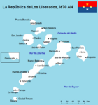
Image:Los Liberados Large Map.png|Map of Los Liberados from 1670 AN | Image:Los Liberados Large Map.png|Map of Los Liberados from 1670 AN | ||
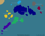
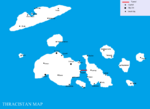
Old Map of Thracistan.png|Map of Thracistan from from 1681 AN | |||
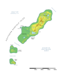
Image:Port Balaine physical map.png|Map of Port Balaine from 1706 AN | Image:Port Balaine physical map.png|Map of Port Balaine from 1706 AN | ||
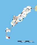
Image:Port Balaine roads map.png|Map of the roads of Port Balaine | Image:Port Balaine roads map.png|Map of the roads of Port Balaine | ||
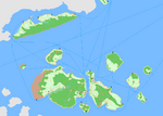
Image:Kantisha and Nortak Islands detailedmap.png|Map of the northern isles | Image:Kantisha and Nortak Islands detailedmap.png|Map of the northern isles by [[Gustaaf Vermeylen]] | ||
</gallery> | </gallery> | ||
==Notes== | |||
Parts copied from Shirewiki article of [https://shireroth.org/shirewiki/Norfolk Norfolk]. | |||
[[Category:Çakaristan]][[Category:Islands]][[Category:Port Balaine]][[Category:Floria]] | [[Category:Çakaristan]][[Category:Islands]][[Category:Port Balaine]][[Category:Floria]] | ||
Latest revision as of 16:57, 14 August 2023
Norfolk Isles (martino: Islas de la Gente del Norte) is an archipelago off the southern coast of Apollonia in the North Raynor Sea. The islands are commonly referred to simply as Norfolk, but geographically are called the Norfolk Isles. Norfolk is one of the few locations to retain the same name throughout the entire history of Micras.
Norfolk has in the past been part of Shireroth, Tymaria and Jingdao, the Republic of Los Liberados, Port Balaine and Thraci Confederation. Today parts are under control of Floria and Çakaristan.
Etymology
Founder Patrick Foley chose the name after Naval Station Norfolk, located in Norfolk, Virginia. The heavy emphasis on the American navy played an important part in forming the culture of Norfolk as a nation.
History

The Republic of Norfolk
Norfolk was originally founded by Patrick Foley around 2000 as one of the early sister states of Audentior and the Flying Islands of Jasonia, thus making it one of the early Apollo Sector micronations. Since Patrick was an avid fan of the United States Navy and eventually would choose that venue for his career, Norfolk was strictly modeled along naval lines. In its time it was known for having a large battleship with its guns firing for the background image of its forum (the USS New Jersey). Norfolk was involved in a number of wars and made use of its vast navy, typically being confined to a geographically small coastal area - land which it maintains to this day as a county of Shireroth. It was involved in the Infernal War between the People's Republic of Hell and the Flying Islands of Jasonia, whereupon at one point the Infernals seized the Norfolkian forum - which at the time was considered a virtual checkmate - and Blackrock interjected and took it back, but not before imposing some of their humor on it by changing the forums to pink girlish colors. After these events the Republic slowly went inactive until it was eventually annexed by Shireroth.
The County of Norfolk
After the plague trade from the other counties dried up and many Norfolkians turned to piracy. The county government is more active again in resisting them, but the pirates remain a powerful force, led by Captain Rackham. Like many pirate gangs, Rackham's leadership was soon replaced by that of Captain Walter Poldark, who established a loose confederation of pirates known as the Maritime Free Republic.
Kildare and Jingdao
Norfolk became part of Kildare when it voted to secede from Shireroth and join the Apollonian Republic. During this time Norfolk was absorbed into Aryasht and ruled from the mainland. While the Aryashti were in control they appointed one of their own, Zaila Vrteti, as ruler of the isles. Vrteti became an immediate program of Aryanization of Norfolk, adopting many Aryashti symbols, religion, government, and cultural practices. This alienated many of the native Norfolkian, who were shared a close kinship with the westernized civilizations that emerged from Audentior and Blackrock. But the Aryashti reign came to an abrupt end with the nuclear catastrophe that wiped out many major cities - including Tymaria City - and resulted in the collapse of the confederation. In its wake the native Norfolkian population rose up to retake their islands, and forced the Aryashti out, aligning themselves with Apollonia's successor, Jingdao.
The Ross Doctrine
The prominent Norfolkian Franklin Ross, whose long line descends back to the Republic, formed the National Republican Party of Norfolk and proceeded to rally the native Norfolkian to his side. This group then forced the relocation of all non-natives (especially the Aryashti) back to Eblis-Rulak, which was acting as successor to Aryasht. Ross then initiated a cultural renaissance that aimed to bring back much of the symbolism and nationalist pride of the Republican era. The new government has begun investing heavily in restoring Norfolk's primary industry as a naval defense manufacturer, forming strong ties with the Kingdom of Batavia.
Los Liberados and Thracistan
In 1668 AN, the southern islands came under the flag of Los Liberados. The capital was Puerto Arcadio. In 1672 AN, Los Liberados joined the Batavian Confederation, but became part of Gran Verionia a year later. Between 1676 and 1677, it was briefly part of Floria, then independent until its demise in 1686 AN.
In 1670 AN, the Thraci came to the northern islands of the Norfolk Isles. They founded Thracistan, which later became part of the Thraci Confederation. In 1706 AN, the territory was ceded to Çakaristan, which founded a state Kantisha and Northak Islands. The former capital of Thracistan, Kadim, remained under Thraci banner until 1711 AN, when that city too ceded to Çakaristan.
Floria and Port Balaine
In 1688 AN, Port Balaine was founded on the vacant southern islands. But after the first decade, the state proved to be non-functional. This led to the Florian invasion of Port Balaine. Despite this invasion being controversial, the southern islands came under the flag of Floria.
Çakaristan
After taking over territory in 1706 and 1711 AN from Thracistan, Çakaristan developed the northern islands, along with the island of Kantisha, into the state of Kantisha and Northak Islands. The former capital of Thracistan, Kadim remained a separate sarkar (district). The intersection of the Equator and Prime Meridian lies between the northern islands. This is marked with an underwater monument 'Middle Micras'.
Maps
Over the centuries, various maps have been made of the Norfolk Isles:
Map of the northern isles by Gustaaf Vermeylen
Notes
Parts copied from Shirewiki article of Norfolk.


