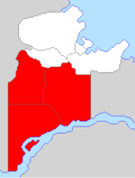
Sibirel
| Sibirel Region Rînlar Sibireles (gr) | |||
| |||

| |||
| Capital | Tawlkar | ||
| Largest cities | Tawlkar, Gerze, Baraŷa, Gentóul | ||
| Demonym | Sibirelian | ||
| Area | 485,496 km² | ||
| - Ranked | 1st | ||
| Population | 1,322,000 (2012) | ||
| - Ranked | 2nd | ||
Sibirel is one of the two regions in Gerenia, in the south of the country. The capital city is Tawlkar.
Geography
The northern half of the region belongs to hilly terrain, while the southern half is spread over the northern slopes of the Adarman Highlands.
Sibirel borders with Mäeklen Region to the north, unclaimed territory to the west and east. The south-eastern and southern border is formed by the Camoleo River and Lake Lamantia, respectively.
Sibirel is rich in minerals, especially lead, but also gold, silver and zinc. Small quantities of coal and natural gas are extracted.
Provinces
Sibirel is further subdivided into three provinces:
History
Sibirel was founded on 8 July 2012 as the "New Adarma Autonomous Region". It was made up of Adarma, Sängeran and West provinces. Clemente Ruiz was the first Governor of the region. His mandate lasted two years, when he was replaced with Victoria Amaral.
Since its foundation, mining was the driving force for development of the region, and resulted in industrialization, especially in Adarma.
In 2015, New Adarma was renamed "Sibirel", and adopted new symbols.
