Tempasuku region

|
This article or section is a work in progress. The information below may be incomplete, outdated, or subject to change. |
| Tempasuk Tempasuku 템파숙 テンパスク (Tenpasuku) |
|
|---|---|
| Geographical region of Phinbella | |
| Region of Tempasuk Kawasan Tempasuk テンパスク地方 Tenpasuku-chihō |
|
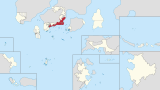
| Location of the Tempasuku region (red) in Phinbella (light yellow) | |
| Country | |
| Territories | |
| Area | |
| • Land | 16,461 km2 (6,356 sq mi) |
| Population (1730 AN) | |
| • Total | 13,680,317 |
| Gross Regional Product | |
| • Total | N/A |
| Time zone | NAT (UTC+05:20) |
The Tempasuk region (Phineaner: Wilayah Tempasuk; IPA: [təmpasʊk]; Taesongean: 템파숙; RR: Tempasuk; MR: T'emp'asuk), also known as the Tempasuku or Tenpasuku region (Sangunese: テンパスク地方, translit.: Tenpasuku-chihō?, IPA: [te(ꜜ)ɰ̃pasɯkɯ̥ tɕiꜜhoː]; Taesongean: 템파숙 지방; RR: Tempasuk jibang; MR: T'emp'asuk chibang) and Tempasuku coast (Sangunese: テンパスク海岸, translit.: Tenpasuku-kaigan?, IPA: [te(ꜜ)ɰ̃pasɯkɯ̥ ka̠iɡã̠ɴ]), is a region located on the south-southeast coast of the Mattimeo peninsula, Cyber-Island Chain. This region includes three territories (federated states) of Turku and Hōri, Drusselstein and Manschūhōria, and a directly-administered territory of Dindings. The Tempasuk region covers an area of 16,461 square kilometers. In 1730 AN, corresponding to March RP 2620, the Tempasuk region had a population of 13,680,317 people.
.
