Kortilhera: Difference between revisions
No edit summary |
No edit summary |
||
| Line 7: | Line 7: | ||
| population = 6,188,135 (1714) | | population = 6,188,135 (1714) | ||
| density = 74 | | density = 74 | ||
| rankpop = | | rankpop = 11 | ||
| area = 84,049 | | area = 84,049 | ||
| rankarea = | | rankarea = 4 | ||
| govex = [[Government of Kortilhera|Executive Council (15)]] | | govex = [[Government of Kortilhera|Executive Council (15)]] | ||
| govleg = [[Government of Kortilhera|Legislative Council (85)]] | | govleg = [[Government of Kortilhera|Legislative Council (85)]] | ||
Latest revision as of 18:03, 6 October 2024
| Kortilhera | |
| Administrative divisions | |
| '
| |
|
| |
| Capital | Ranti Lloperat |
| Largest cities | Boomwatch, Kerhala |
|
| |
| Population | |
|
6,188,135 (1714) |
|
74 per km2 |
|
11 of 17 |
|
| |
| Area | |
|
84,049 km2 |
|
4 of 17 |
|
| |
| Government | |
|
Executive Council (15) |
|
Legislative Council (85) |
|
| |
| Official language(s) | Sanaman |
| Other language(s) | Cisamarrese, Passikaans, Istvanistani |
| Local religion | Somanes, Cedrism, Nazarenism |
| Subdivision code | KOR |
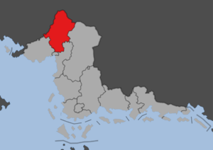
Kortilhera is a people's republic in Sanama. It has an area of 71,000 km2, a population of six million and a population density of 85 per km2, it is one of the least populated republics while also one of the largest. The republic was formed in 1702 following the Sanaman Civil War. The south of the republic is dominated by forests and rolling hills, interspersed with farmland, mostly rice paddies. The north of the republic consists of the foothills of the Kortilhera Mountains, rising up to over 2,000 meters. Lake Meerzicht, the largest body of water in Sanama, is also located here. The capital Ranti Lloperat is located close to the center of the republic. Kortilhera is bordered by Cisamarra to the west, Highpass to the north, Amarra Esa to the east, Indipendensa to the southeast, Fatehpur Sikri to the south and Panetira to the southwest.

