Nurthaven and Antruusbuurg Canal: Difference between revisions
No edit summary |
m →History |
||
| (40 intermediate revisions by 4 users not shown) | |||
| Line 1: | Line 1: | ||
The ''' | {| style="background-color: #F8F9FA; float: right; clear: right; width: 300px; margin:0 0 15px 15px; border:1px solid #aaa; border-spacing: 3px; text-align: left; font-size: 95%;" | ||
|+ | |||
! colspan="2" style="padding: 3px; background-color: #d3defc; text-align: center; vertical-align: middle; font-size: 115%;" |Nurthaven & Antruusbuurg Canal | |||
|- | |||
| colspan="2" style="padding: 2px; background-color: #d3defc; text-align: center; vertical-align: middle; font-size: 100%;" |''Nuurdhaƀe-Andreezböörchkenaal'' ([[Meckelnish language|mk]]) | |||
|- | |||
| colspan="2" style="vertical-align:top; text-align: center;" |[[File:N&A_Canal_Authority_logo.png|300px]] | |||
|- | |||
| colspan="2" style="vertical-align:top; text-align: center;" |Logo of the canal authority | |||
|- | |||
| colspan="2" style="padding: 2px; background-color: #d3defc; text-align: center; vertical-align: middle; font-size: 100%;" |'''Specifications''' | |||
|- | |||
|'''Length''' | |||
| 288 km (179 mi) | |||
|- | |||
|'''Maximum boat length''' | |||
|294 m (965 ft) | |||
|- | |||
|'''Maximum boat beam''' | |||
|32 m (106 ft) | |||
|- | |||
|'''Maximum boat draft''' | |||
|12 m (40 ft) | |||
|- | |||
|'''Locks''' | |||
|3 locks up, 3 down; all two lanes | |||
|- | |||
|'''Navigation authority''' | |||
|Nurthaven & Antruusbuurg Canal Navigation Authority | |||
|- | |||
|'''Main office''' | |||
|[[Antruusbuurg]], {{Team flag|Iselande}} | |||
|- | |||
| colspan="2" style="padding: 2px; background-color: #d3defc; text-align: center; vertical-align: middle; font-size: 100%;" |'''History''' | |||
|- | |||
|'''Original construction''' | |||
|ca.{{AN|1500}} | |||
|- | |||
|'''Reconstruction began''' | |||
|{{AN|1700}} | |||
|- | |||
|'''Date opened''' | |||
|{{AN|1702}} | |||
|- | |||
| colspan="2" style="padding: 2px; background-color: #d3defc; text-align: center; vertical-align: middle; font-size: 100%;" |'''Geography''' | |||
|- | |||
|'''Start point''' | |||
|[[Port of Antruusbuurg]] ([[Clear Sea]]), {{Team flag|Iselande}} | |||
|- | |||
|'''End point''' | |||
|[[Port of Nurthaven]], {{Team flag|Iselande}} | |||
|- | |||
|'''Connects''' | |||
|[[Northern Sea]] across [[Jääland Peninsula]] | |||
|} | |||
The '''Nurthaven & Antruusbuurg Canal''', also known formally as the '''N&A Canal''', is a major canal and region at the foot of the [[Jääland Peninsula]] in [[Iselande]], a constituent country within the [[United Kingdom of Meckelnburgh]]. The canal was first constructed by [[Cranda]] around 2100 [[ASC]], or {{AN|1500}}. As the northern end of the peninsula is surrounded by permanent sea ice, the canal is the only access point to transit a complete northern route above the continent. The canal is managed by the Nurthaven & Antruusbuurg Canal Navigation Authority, a government agency of Meckelnburgh. | |||
The canal | The canal bisects the northern tip of [[Apollonia]] and, as the name suggests, connects from the [[Port of Nurthaven]] on the east coast to the [[Port of Antruusbuurg]] on the west coast, near the larger cities of [[Nurthaven]] and [[Antruusbuurg]] respectively. From Nurth Lake as a midpoint, it approximately follows the path of the Est River to the east and the Anglie and Cold Rivers to the west. As of {{AN|1752}}, the canal is controlled by Meckelnburgh and is bordered on the southern side of the canal zone by the constituent kingdoms of [[Anglien]] (to the west) and [[Jutien]] (to the east) in [[Lac Glacei]]. | ||
The canal is one of the most ambitious engineering projects ever completed on [[Micras]] and extends nearly 288 km (179 mi). Surveyors used a combination of existing waterways and man-made canals to create a navigable water course for shipping in and out of the [[Clear Sea]] and past the [[Straits of Artsessdun]]. The canal uses several locks to control water levels and allow ships to successfully traverse the varied topography, including the southern end of the Brussels Hills. | |||
== Canal == | |||
== | === Specifications === | ||
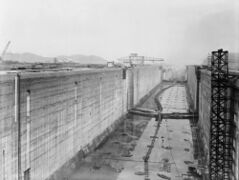
The Nurthaven & Antruusbuurg Canal is a total of 288 km (179 mi) in length. It is built to [[Pontecorvo Firm#Commercial vessels|AlkhivaMax standards]], derived from the Port of Alkhiva in [[Alduria]], with a maximum vessel length of 294 m and deadweight tonnage of approximately 110,000 (5,100 twenty-foot equivalent units). The canal is capable of two-way traffic at each lock. | |||
The | === Pathway === | ||
[[File:N&A Canal new map.png|thumb|500x500px|The N&A Canal in detail (watercourse width not to scale)]] | |||
Beginning in the [[Port of Antruusbuurg]], between [[Antruusbuurg]] and [[North Antrusburgh]], the canal flows east along the Cold River via Canal One, which contains Locks A and B. Canal One controls access and connects the Cold River to the large Anglie River. Midway across the peninsula, vessels flow under the [[Jääland Bridge]] on the Anglie River. | |||
Canal One then connects to Nurth Lake near the town of the same name. The lake is dammed and has two locks of its own (West and East), whose primary purpose to to act as ballast for controlling the water levels on the entire canal. If the locks at Canal One or Canal Two need more or less water, the large reservoir at the lake can quickly adjust these levels. | |||
[[Category: Geography]][[Category: Lac Glacei]] | The canal then flows east from the lake to Canal Two where Locks C and D are located. It finally connects to the Est River where it empties at the [[Port of Nurthaven]], north of [[Nurthaven]] proper. | ||
=== Infrastructure === | |||
The canal is followed on its south banks by Jääland Motorway J5, the controlled-access highway in the [[Transport in Iselande|Iselande road system]] inherited from [[Lac Glacei]]. The motorway provides road access to all locks along the canal and the town of Nurth Lake. The canal is crossed by the Jääland Bridge on Iselande Highway H47, connecting to Iselande H10 in the Orko Valley. At the western mouth of the canal, Motorway J2 between Antruusbuurg and North Antrusburgh meets Motorway J5 before it crosses under the canal via the HMS ''Kristana'' Tunnel. Motorway J2 ultimately reaches [[Fenixtune]] over the Brussels Hills. At the eastern mouth, Motorway J1 meets Motorway J5 north of Nurthaven. A ferry service through the Port of Nurthaven connects Nurthaven with Fenixtune. | |||
The Nurthaven & Antruusbuurg Portage Railroad (N&APRR) delivers equipment along the canal as well as providing cargo and passenger services between the municipalities of the Canal Zone. The line runs from Antruusbuurg to Nurthaven via Nurth Lake. | |||
At the ports on either end of the canal are detachments of the Meckelnburgh and Lac Glacei militaries as part of the [[Lac Glacei–Meckelnburgh Canal Security Mission]]. The headquarters for the Mission are in Antruusbuurg, shared with the main base of the [[Royal Meckelnburgh Navy|Royal Meckelnburgh Navy's]] Fourth Fleet. | |||
== History == | |||
=== Origins === | |||
The canal was maintained by several other states succeeding Cranda after its collapse, primarily by [[Alexandria]] during their brief tenure through the [[Diet of the Clear Sea]]. The canal fell into disuse and neglect when [[Gralus]] took over the region from {{AN|1530}} to {{AN|1542}}. During this time, significant siltation occurred and numerous locks became irreparable.[[File:N and A Canal.png|thumb|250px|The N&A Canal in ancient times|left]] | |||
=== Lac Glacei annexation === | |||
In {{AN|1699}}, [[Lac Glacei]] laid claim to the Nurthaven & Antruusbuurg Canal and began dredging the channel in order to allow shipping traffic to once again utilize an important means of commerce. [[Meckelnburgh]] had also cited interest in assisting with restoring the canal as they too have a vested interest in improving commerce within the [[Clear Sea]], as the canal could be the only eastwardly access from Meckelnburgh to the remainder of [[Micras]]. | |||
As the course of the canal would cross the frontier of [[Jääland]], as well as block that country's future ability to expand southwards, the move to annex the canal region was brought to the attention of domestic authorities there by the [[Apollonia Command|Apollonian Continental Theatre Command]] of the [[Raspur Pact]], of which Jääland was a member. A battalion-sized battlegroup of the [[Allied Reconstruction Mission in Hurmu]] airlifted to [[Hellistelli International Airport]] so as to provide support. | |||
On arrival the [[UDF]] {{tooltip|Överste|Colonel}} attached to the deployed force as its political officer was obliged to report back an absence of the necessary political will in Jääland that would be required to effect an occupation of the canal zone. Following this, the deployed force retasked towards focusing on enhancing airport security. | |||
=== Reconstruction === | |||
[[File:N and A Canal Now.png|thumb|The future N&A Canal at the time of Jääland]] | |||
==== 1700 AN ==== | |||
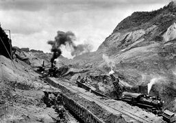
Beginning in {{AN|1700}}, construction crews from Lac Glacei and Meckelnburgh arrived in the area to begin dredging operations. The ultimate objective was to clear away several centuries of siltation in the canal. The majority of Lac Glacei's crews were stationed in [[Nurthaven]], while those of Meckelnburgh were stationed in [[Antruusbuurg]]. In areas that maintained natural water flow, such as rivers, siltation was not as much of a problem as in areas such as man-made canals and in the four locks, which had completely silted in from years of disuse. | |||
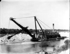
Dredging ships were employed from both ends to begin clearing the waterways from the ocean sides inland. But additional crews were brought in to work on the locks from the sides of the canal. In addition, Lac Glacei employed the use of specialized floating steam shovels to begin dredging operations further in, such as along the Anglie River. | |||
As dredging continued well into late {{AN|1700}}, work also began on the [[Jääland Bridge]]. The bridge spans a little over one mile and was paid for by Lac Glacei, at a cost of 20 million [[Glaceian blanc|blanc]] (LGB), to assist in creating access for commerce with Jääland, and in fulfilling their commitment to not completely land-lock the northerly state. Construction began on piers located centrally along the Anglie River at its narrowest point. The pylons are elevated to allow shipping to pass unhindered along the river below. Once complete, the bridge provided Jääland with direct access to canal ports and shipping at the [[Port of Nurthaven]], greatly increasing their ability to import and export goods. | |||
<gallery mode="packed-hover"> | |||
Image:Steam shovel na canal.jpg|''A floating steam shovel dredging the canal'' | |||
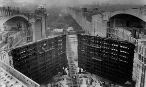
Image:Na canal lock gates.jpg|''Lock gates under construction'' | |||
Image:Na canal locks.jpg|''Locks under construction'' | |||
Image:Na canal nurth dam.jpg|''Dam at Nurth Lake'' | |||
Image:Na canal trains.jpg|''Trains hauling dredged soil from the canal'' | |||
Image:Na canal walls.jpg|''Walls of the man-made canal'' | |||
</gallery> | |||
==== 1701–1702 AN ==== | |||
By early {{AN|1701}}, dredging efforts had cleared the Est River from the Port of Nurthaven to Nurth Lake, and repaired Locks C and D. Crews from Meckelnburgh had managed to clear the Cold River to Locks A and B. This has allowed construction crews to work on repairing the locks and preventing further siltation in areas that were recently cleared. The dam at Nurth Lake was also repaired, which allowed engineers to drain much of the river between the lake and Lock B. This has made that particular section of the river much more accessible to crews and allowed for faster construction of the Jääland Bridge. | |||
Spring of {{AN|1702}} saw the completion of dredging the Anglie River, the last and longest section of the Nurthaven & Antruusbuurg Canal. Although most construction was halted during the winter months, the combined crews from Lac Glacei and Meckelnburgh worked until the ground froze solid and began again at first thaw. As such they were able to have the canal ready for traffic by {{AN|1702}}.I. | |||
[[File:Lucienne Arthur - Nurthaven and Antruusbuurg Canal.jpeg|thumb|250x250px|''The locks at Nurth Lake'' by [[Lucienne Arthur]]]] | |||
=== Reopening === | |||
An opening ceremony was held on {{AN|1702}}.I.4, with representatives from Jääland, Lac Glacei and Meckelnburgh attending a ribbon cutting and the passage of the first ship through the canal, the HMS ''Kristana''. The Jääland Bridge, which took three years to complete, was opened in early {{AN|1703}}. The bridge provided a commerce link for Jääland to export goods through the major port at Nurthaven. | |||
Despite claims that the canal would cross Jääland, its course ran directly south of their border in unclaimed territory. Lac Glacei established a 6-to-12 km perimeter zone on either side of the canal for security. Lac Glacei and Meckelnburgh further collaborated to create the [[Lac Glacei-Meckelnburgh Canal Security Mission|Canal Security Mission]] to ensure the safe and secure operation of the canal. Assurances were made to Jääland that provided them unrestricted access to the canal for border crossings and commerce. Lac Glacei also formally extended recognition of Jääland's sphere of influence over the northern unclaimed portion of the [[Jääland Peninsula]], granting them the ability to expand there if desired. | |||
=== Geopolitical changes === | |||
Following [[The Troubles]] on the peninsula from {{AN|1707}} to {{AN|1709}}, the country of Jääland endured an economic, political and environmental collapse, leading to annexation by Meckelnburgh and creating the [[Grand Duchy of Iselande]] to the canal zone's north. The peninsula's new capital was formed at [[North Antrusburgh]], near the similarly named city of Antruusbuurg. The canal continued to be owned by Lac Glacei, who operated it as a reliable shipping corridor above northern Apollonia. | |||
In {{AN|1752}}, Lac Glacei ceded ownership of the Nurthaven & Antruusbuurg Canal to Meckelnburgh, joining it to Iselande as the grand duchy's third region, the Canal Zone. The zone was also expanded southward along the west coast to include the detached city of Antruusbuurg proper with the Port of Antruusbuurg itself, which, unlike Nurthaven, had not actually been in the canal's territory. Meckelnburgh continues to fly the flag of Lac Glacei at the time of cession along the canal. | |||
Afterwards, in {{AN|1753}}, Meckelnburgh began construction on the HMS ''Kristana'' Tunnel in the Port of Antruusbuurg, intended to provide an uninterrupted vehicle connection between North Antrusburgh and Antruusbuurg proper underneath the canal. The estimated completion date is {{AN|1758}}. | |||
[[Category: Geography]] | |||
[[Category: Lac Glacei]] | |||
[[Category: Meckelnburgh]] | |||
[[Category:Iselande]] | |||
Latest revision as of 23:14, 21 January 2026
| Nurthaven & Antruusbuurg Canal | |
|---|---|
| Nuurdhaƀe-Andreezböörchkenaal (mk) | |
| Logo of the canal authority | |
| Specifications | |
| Length | 288 km (179 mi) |
| Maximum boat length | 294 m (965 ft) |
| Maximum boat beam | 32 m (106 ft) |
| Maximum boat draft | 12 m (40 ft) |
| Locks | 3 locks up, 3 down; all two lanes |
| Navigation authority | Nurthaven & Antruusbuurg Canal Navigation Authority |
| Main office | Antruusbuurg, |
| History | |
| Original construction | ca.1500 AN |
| Reconstruction began | 1700 AN |
| Date opened | 1702 AN |
| Geography | |
| Start point | Port of Antruusbuurg (Clear Sea), |
| End point | Port of Nurthaven, |
| Connects | Northern Sea across Jääland Peninsula |
The Nurthaven & Antruusbuurg Canal, also known formally as the N&A Canal, is a major canal and region at the foot of the Jääland Peninsula in Iselande, a constituent country within the United Kingdom of Meckelnburgh. The canal was first constructed by Cranda around 2100 ASC, or 1500 AN. As the northern end of the peninsula is surrounded by permanent sea ice, the canal is the only access point to transit a complete northern route above the continent. The canal is managed by the Nurthaven & Antruusbuurg Canal Navigation Authority, a government agency of Meckelnburgh.
The canal bisects the northern tip of Apollonia and, as the name suggests, connects from the Port of Nurthaven on the east coast to the Port of Antruusbuurg on the west coast, near the larger cities of Nurthaven and Antruusbuurg respectively. From Nurth Lake as a midpoint, it approximately follows the path of the Est River to the east and the Anglie and Cold Rivers to the west. As of 1752 AN, the canal is controlled by Meckelnburgh and is bordered on the southern side of the canal zone by the constituent kingdoms of Anglien (to the west) and Jutien (to the east) in Lac Glacei.
The canal is one of the most ambitious engineering projects ever completed on Micras and extends nearly 288 km (179 mi). Surveyors used a combination of existing waterways and man-made canals to create a navigable water course for shipping in and out of the Clear Sea and past the Straits of Artsessdun. The canal uses several locks to control water levels and allow ships to successfully traverse the varied topography, including the southern end of the Brussels Hills.
Canal
Specifications
The Nurthaven & Antruusbuurg Canal is a total of 288 km (179 mi) in length. It is built to AlkhivaMax standards, derived from the Port of Alkhiva in Alduria, with a maximum vessel length of 294 m and deadweight tonnage of approximately 110,000 (5,100 twenty-foot equivalent units). The canal is capable of two-way traffic at each lock.
Pathway

Beginning in the Port of Antruusbuurg, between Antruusbuurg and North Antrusburgh, the canal flows east along the Cold River via Canal One, which contains Locks A and B. Canal One controls access and connects the Cold River to the large Anglie River. Midway across the peninsula, vessels flow under the Jääland Bridge on the Anglie River.
Canal One then connects to Nurth Lake near the town of the same name. The lake is dammed and has two locks of its own (West and East), whose primary purpose to to act as ballast for controlling the water levels on the entire canal. If the locks at Canal One or Canal Two need more or less water, the large reservoir at the lake can quickly adjust these levels.
The canal then flows east from the lake to Canal Two where Locks C and D are located. It finally connects to the Est River where it empties at the Port of Nurthaven, north of Nurthaven proper.
Infrastructure
The canal is followed on its south banks by Jääland Motorway J5, the controlled-access highway in the Iselande road system inherited from Lac Glacei. The motorway provides road access to all locks along the canal and the town of Nurth Lake. The canal is crossed by the Jääland Bridge on Iselande Highway H47, connecting to Iselande H10 in the Orko Valley. At the western mouth of the canal, Motorway J2 between Antruusbuurg and North Antrusburgh meets Motorway J5 before it crosses under the canal via the HMS Kristana Tunnel. Motorway J2 ultimately reaches Fenixtune over the Brussels Hills. At the eastern mouth, Motorway J1 meets Motorway J5 north of Nurthaven. A ferry service through the Port of Nurthaven connects Nurthaven with Fenixtune.
The Nurthaven & Antruusbuurg Portage Railroad (N&APRR) delivers equipment along the canal as well as providing cargo and passenger services between the municipalities of the Canal Zone. The line runs from Antruusbuurg to Nurthaven via Nurth Lake.
At the ports on either end of the canal are detachments of the Meckelnburgh and Lac Glacei militaries as part of the Lac Glacei–Meckelnburgh Canal Security Mission. The headquarters for the Mission are in Antruusbuurg, shared with the main base of the Royal Meckelnburgh Navy's Fourth Fleet.
History
Origins
The canal was maintained by several other states succeeding Cranda after its collapse, primarily by Alexandria during their brief tenure through the Diet of the Clear Sea. The canal fell into disuse and neglect when Gralus took over the region from 1530 AN to 1542 AN. During this time, significant siltation occurred and numerous locks became irreparable.

Lac Glacei annexation
In 1699 AN, Lac Glacei laid claim to the Nurthaven & Antruusbuurg Canal and began dredging the channel in order to allow shipping traffic to once again utilize an important means of commerce. Meckelnburgh had also cited interest in assisting with restoring the canal as they too have a vested interest in improving commerce within the Clear Sea, as the canal could be the only eastwardly access from Meckelnburgh to the remainder of Micras.
As the course of the canal would cross the frontier of Jääland, as well as block that country's future ability to expand southwards, the move to annex the canal region was brought to the attention of domestic authorities there by the Apollonian Continental Theatre Command of the Raspur Pact, of which Jääland was a member. A battalion-sized battlegroup of the Allied Reconstruction Mission in Hurmu airlifted to Hellistelli International Airport so as to provide support.
On arrival the UDF Överste attached to the deployed force as its political officer was obliged to report back an absence of the necessary political will in Jääland that would be required to effect an occupation of the canal zone. Following this, the deployed force retasked towards focusing on enhancing airport security.
Reconstruction

1700 AN
Beginning in 1700 AN, construction crews from Lac Glacei and Meckelnburgh arrived in the area to begin dredging operations. The ultimate objective was to clear away several centuries of siltation in the canal. The majority of Lac Glacei's crews were stationed in Nurthaven, while those of Meckelnburgh were stationed in Antruusbuurg. In areas that maintained natural water flow, such as rivers, siltation was not as much of a problem as in areas such as man-made canals and in the four locks, which had completely silted in from years of disuse.
Dredging ships were employed from both ends to begin clearing the waterways from the ocean sides inland. But additional crews were brought in to work on the locks from the sides of the canal. In addition, Lac Glacei employed the use of specialized floating steam shovels to begin dredging operations further in, such as along the Anglie River.
As dredging continued well into late 1700 AN, work also began on the Jääland Bridge. The bridge spans a little over one mile and was paid for by Lac Glacei, at a cost of 20 million blanc (LGB), to assist in creating access for commerce with Jääland, and in fulfilling their commitment to not completely land-lock the northerly state. Construction began on piers located centrally along the Anglie River at its narrowest point. The pylons are elevated to allow shipping to pass unhindered along the river below. Once complete, the bridge provided Jääland with direct access to canal ports and shipping at the Port of Nurthaven, greatly increasing their ability to import and export goods.
-
 A floating steam shovel dredging the canal
 -
 Lock gates under construction
 -
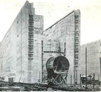 Locks under construction
 -
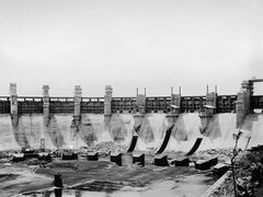 Dam at Nurth Lake
 -
 Trains hauling dredged soil from the canal
 -
 Walls of the man-made canal


1701–1702 AN
By early 1701 AN, dredging efforts had cleared the Est River from the Port of Nurthaven to Nurth Lake, and repaired Locks C and D. Crews from Meckelnburgh had managed to clear the Cold River to Locks A and B. This has allowed construction crews to work on repairing the locks and preventing further siltation in areas that were recently cleared. The dam at Nurth Lake was also repaired, which allowed engineers to drain much of the river between the lake and Lock B. This has made that particular section of the river much more accessible to crews and allowed for faster construction of the Jääland Bridge.
Spring of 1702 AN saw the completion of dredging the Anglie River, the last and longest section of the Nurthaven & Antruusbuurg Canal. Although most construction was halted during the winter months, the combined crews from Lac Glacei and Meckelnburgh worked until the ground froze solid and began again at first thaw. As such they were able to have the canal ready for traffic by 1702 AN.I.

Reopening
An opening ceremony was held on 1702 AN.I.4, with representatives from Jääland, Lac Glacei and Meckelnburgh attending a ribbon cutting and the passage of the first ship through the canal, the HMS Kristana. The Jääland Bridge, which took three years to complete, was opened in early 1703 AN. The bridge provided a commerce link for Jääland to export goods through the major port at Nurthaven.
Despite claims that the canal would cross Jääland, its course ran directly south of their border in unclaimed territory. Lac Glacei established a 6-to-12 km perimeter zone on either side of the canal for security. Lac Glacei and Meckelnburgh further collaborated to create the Canal Security Mission to ensure the safe and secure operation of the canal. Assurances were made to Jääland that provided them unrestricted access to the canal for border crossings and commerce. Lac Glacei also formally extended recognition of Jääland's sphere of influence over the northern unclaimed portion of the Jääland Peninsula, granting them the ability to expand there if desired.
Geopolitical changes
Following The Troubles on the peninsula from 1707 AN to 1709 AN, the country of Jääland endured an economic, political and environmental collapse, leading to annexation by Meckelnburgh and creating the Grand Duchy of Iselande to the canal zone's north. The peninsula's new capital was formed at North Antrusburgh, near the similarly named city of Antruusbuurg. The canal continued to be owned by Lac Glacei, who operated it as a reliable shipping corridor above northern Apollonia.
In 1752 AN, Lac Glacei ceded ownership of the Nurthaven & Antruusbuurg Canal to Meckelnburgh, joining it to Iselande as the grand duchy's third region, the Canal Zone. The zone was also expanded southward along the west coast to include the detached city of Antruusbuurg proper with the Port of Antruusbuurg itself, which, unlike Nurthaven, had not actually been in the canal's territory. Meckelnburgh continues to fly the flag of Lac Glacei at the time of cession along the canal.
Afterwards, in 1753 AN, Meckelnburgh began construction on the HMS Kristana Tunnel in the Port of Antruusbuurg, intended to provide an uninterrupted vehicle connection between North Antrusburgh and Antruusbuurg proper underneath the canal. The estimated completion date is 1758 AN.