Tempasuku region: Difference between revisions
No edit summary |
No edit summary |
||
| (6 intermediate revisions by the same user not shown) | |||
| Line 3: | Line 3: | ||
<!-- See Template: Infobox settlement for additional fields and descriptions --> | <!-- See Template: Infobox settlement for additional fields and descriptions --> | ||
| name = Tempasuk | | name = Tempasuk | ||
| native_name = {{nobold|''Tempasuku''<br> | | native_name = {{nobold|''Tempasuku''<br>템파숙<br>テンパスク (''Tenpasuku'')}} | ||
| native_name_lang = ms | | native_name_lang = ms | ||
| official_name = Region of Tempasuk<br>{{nobold|''Kawasan Tempasuk''<br>テンパスク地方 ''Tenpasuku-chihō''}} | | official_name = Region of Tempasuk<br>{{nobold|''Kawasan Tempasuk''<br>テンパスク地方 ''Tenpasuku-chihō''}} | ||
| Line 23: | Line 23: | ||
| subdivision_name1 = {{unbulleted list|[[Dindings]] | | subdivision_name1 = {{unbulleted list|[[Dindings]] | ||
|{{team flag|Turku and Hōri}} | |{{team flag|Turku and Hōri}} | ||
| | |{{team flag|Drusselstein}} | ||
|{{team flag|Manschūhōria}} | |{{team flag|Manschūhōria}} | ||
}} | }} | ||
| Line 46: | Line 46: | ||
| demographics1_title1 = Total | | demographics1_title1 = Total | ||
| demographics1_info1 = N/A | | demographics1_info1 = N/A | ||
}}The '''Tempasuk region''' ({{Lang-ms|Wilayah Tempasuk}}; {{Lang-ts|템파숙|Tempasuk|T'emp'asuk}}), | }}The '''Tempasuk region''' ({{Lang-ms|Wilayah Tempasuk}}; {{small|IPA:}} {{IPA|[[wikipedia:Help:IPA/Malay|[təmpasʊk]]]}}; {{Lang-ts|템파숙|Tempasuk|T'emp'asuk}}), known as the {{nihongo|lead=yes|'''Tempasuku''' or '''Tenpasuku region'''|テンパスク地方|Tenpasuku-chihō|extra={{small|IPA:}} {{IPA|[[wikipedia:Help:IPA/Japanese|[te(ꜜ)ɰ̃pasɯkɯ̥ tɕiꜜhoː]]]}}; {{lang-ts|템파숙 지방|Tempasuk jibang|T'emp'asuk chibang}}}} and also known as {{nihongo|lead=yes|'''Tempasuku coast'''|テンパスク海岸|Tenpasuku-kaigan|extra={{small|IPA:}} {{IPA|[[wikipedia:Help:IPA/Japanese|[te(ꜜ)ɰ̃pasɯkɯ̥ ka̠iɡã̠ɴ]]]}}}}, is a region located on the south-southeast coast of the [[Mattimeo peninsula]], [[Cyber-Island Chain]]. This region includes three [[Territories of Phinbella|territories]] (federated states) of [[Turku and Hōri]], [[Drusselstein]] and [[Manschūhōria]], and a directly-administered territory of [[Dindings]], this region often also includes the [[Scattered Islands of the Ieu'ryïan Strait District|Scattered Islands of the Ieu'ryïan Strait]] and the [[Ssamaritan Islands District|Ssamaritan Islands]] which are under the administration of [[Oriental Hispanioéire Taemhwan]], where the area is known as the Taemhwanian Tempasuk, collectively part of the [[Taemhwanian Iurokei]] and [[Phineaner-Eurphineonesian Taemhwanian]]. The Tempasuk region covers an area of 16,461 square kilometers. In {{AN|3|2024}}, corresponding to March {{RP|2024}}, the Tempasuk region had a population of 13,680,317 people. | ||
. | |||
Latest revision as of 16:07, 23 July 2024

|
This article or section is a work in progress. The information below may be incomplete, outdated, or subject to change. |
| Tempasuk Tempasuku 템파숙 テンパスク (Tenpasuku) |
|
|---|---|
| Geographical region of Phinbella | |
| Region of Tempasuk Kawasan Tempasuk テンパスク地方 Tenpasuku-chihō |
|
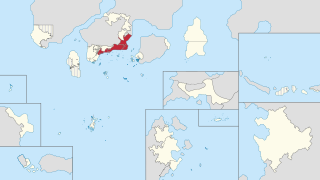
| Location of the Tempasuku region (red) in Phinbella (light yellow) | |
| Country | |
| Territories | |
| Area | |
| • Land | 16,461 km2 (6,356 sq mi) |
| Population (1730 AN) | |
| • Total | 13,680,317 |
| Gross Regional Product | |
| • Total | N/A |
| Time zone | NAT (UTC+05:20) |
The Tempasuk region (Phineaner: Wilayah Tempasuk; IPA: [təmpasʊk]; Taesongean: 템파숙; RR: Tempasuk; MR: T'emp'asuk), known as the Tempasuku or Tenpasuku region (Sangunese: テンパスク地方, translit.: Tenpasuku-chihō?, IPA: [te(ꜜ)ɰ̃pasɯkɯ̥ tɕiꜜhoː]; Taesongean: 템파숙 지방; RR: Tempasuk jibang; MR: T'emp'asuk chibang) and also known as Tempasuku coast (Sangunese: テンパスク海岸, translit.: Tenpasuku-kaigan?, IPA: [te(ꜜ)ɰ̃pasɯkɯ̥ ka̠iɡã̠ɴ]), is a region located on the south-southeast coast of the Mattimeo peninsula, Cyber-Island Chain. This region includes three territories (federated states) of Turku and Hōri, Drusselstein and Manschūhōria, and a directly-administered territory of Dindings, this region often also includes the Scattered Islands of the Ieu'ryïan Strait and the Ssamaritan Islands which are under the administration of Oriental Hispanioéire Taemhwan, where the area is known as the Taemhwanian Tempasuk, collectively part of the Taemhwanian Iurokei and Phineaner-Eurphineonesian Taemhwanian. The Tempasuk region covers an area of 16,461 square kilometers. In 1730 AN, corresponding to March RP 2620, the Tempasuk region had a population of 13,680,317 people.
.
