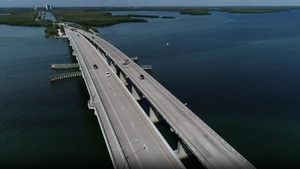
Isles of Caputia Belt Bridge

The Isles of Caputia Belt Bridge, officially the Elizabeth I Bridge, is a fixed link composed of two parallel bridges crossing the Karsten Sound in Isles of Caputia, Nouvelle Alexandrie. It is a total of 12.7 km (7.9 mi) long. The northern terminus of the bridge is at Schenenwalt, Karsten, while the southern terminus is at Valheld, Gotfriedland.
The bridge connects the road networks of Karsten and Godfriedland, the two main islands of the Isles of Caputia. A data cable is also included, linking the data transmission of the entire region together. The construction of the Belt Bridge have connected the two isles of Caputia together by road.
The bridge was designed by Alfonso Duamal and Ricardo Estafopola.
The reasoning to construct a continuous causeway, instead of a suspension bridge design, was to avoid interfering with air traffic lanes crossing the Karsten Sound, as well as providing a clear shipping channel for ships. Construction began in 1730 AN, with the bridge opening to traffic on 1.VIII.1734 AN.
History
The construction of a fixed link across the Karsten Sound dates back to 1710 AN, when a memorandum was signed by the Congress of the Isles and Governor (and future President) Gerhardt Eugen Seydlitz. Funding was finally secured in 1729 AN under the National Infrastructure Plan of President Marissa Santini. Under the so-called NHN MegaProjects program, €1.4 billion was secured for a double fixed link bridge. The Isles of Caputia Region provided a further €600 million in funding, with the Cities of Schenenwalt and Valheld themselves matching investment at €50 million each.
A tender was awarded to a joint venture of ESB Construction, National Construction Corporation, and Parap Construction and Engineering. Construction started on III.1730 AN, with a consolidated construction plan beginning from both sides as Schenenwalt and Valheld simultaneously. King Sinchi Roca stood midway at the purpose-built bascule when the bridge was completed in VI.1734 AN. The official dedication took place the following month, with Sinchi Rooca as the host of the event. The bridge opened for public traffic later that day.
The bridge replaced two ferries that previously existed, the only means of crossing the Karsten Sound by car; Schenenwalt-Valheld and Prestkost-Dreigen. Both remain in operation, but traffic on the bridge has replaced ferry travel by more than 85%. Since opening, in 1734 AN, almost 2 million people travelled over the Elizabeth I Bridge. This number is predicted to increase to more than 8 million by 1740 AN.
Bridge features
At 12.7 km, the bridge stretches across the Karsten Sound. The structure has a total mass of 75,000 tonnes and consists of two separate high-level trestle bridges, each supporting two-lane limited access roads with a hard shoulder, as well as a cycling and pedestrian lane. Both rest in a hortizontal girder that spans the entirerty of both bridges. On both appraoches to the bridge, the girder is supported by concrete piers, 25 meter (82 ft) in width. The fixed bascule is 185 m (606 ft) high, allowing shipping 38 m (124 ft) of head room under the main spans. The bascule is 515 m (1,690 ft) long. A girder and fixed convex bascule shape was chosen to provide the necessary height required for the major shipping traffic traversing the Karsten Sound.
The bridge is supported by bearings wieghing up to 20 tonnes (44,000 lbs) each, capable of bearing vertical loads up to 96,000 kN (22,000,000 lbf) in a longitudinal direction and up to 40,000 kN (9,000,000 lbf) in transverse direction. The bearings were designed and installed by Parap Construction and Engineering, taking knowledge of the C1 motorway's Tolevera Bridge, which has roughly the same length and width. Compression spring dampers were installed to combat vibrations caused by shipping traffic and wind and temperature conditions.
Environmental effects
To combat concerns of environmental impacts on the seabed, and to promote marine life, ESB Construction, during construction of the bridge, created a dedicated artificial reef located at the piers of the bascule. It has since been covered in marine organisms. A secondary sheltered area for marine life, underneath the concrete piers of both approaches, was also installed.