Phinbellan Unincorporated Territory
From MicrasWiki
Jump to navigationJump to search

|
This article or section is a work in progress. The information below may be incomplete, outdated, or subject to change. |
| Phinbellan Unincorporated Territory Wilayah Tidak Diperbadanankan Phinbella |
|||
|---|---|---|---|
| Directly-administered territory | |||
|
|||
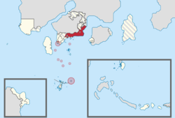
| Location of Phinbellan Unincorporated Territory, Nijigapura, Konohagakure, Marley-Eldia and Paradis Islands marked circle, while other parts marked red. | |||
| Country | |||
| Administrative center | None | ||
| Largest city | Nijigapura | ||
| Settements | 50 | ||
| Government | |||
| • Body | None | ||
| Population (RP 2617) | |||
| • Total | 5,391,000 | ||
| • Density | 1,200/km2 (3,000/sq mi) | ||
| Demographics | |||
| • Languages | Phineaner, Gangwol Phineaner, Taesongean, Afrikaans, Romansh, Kadazandusun | ||
| Time zones | NAT (UTC+4) | ||
| PPT (UTC+5:20) | |||
| Postcode | 100xxx-139xxx | ||
| ISO 3166 code | PH-UIT | ||

