Ramez (province)
From MicrasWiki
Jump to navigationJump to search
| Province of Ramez Provincia de Ramez (es) Proziu'ad Ramez (gr) | |||
| |||

| |||
| Capital | Ramez City | ||
| Largest city | Ramez City | ||
| Language | English, Spanish, Gerenian | ||
| Demonym | Ramish | ||
| - Adjective | Ramish | ||
| Region type | Province | ||
| Area | 6,984 km² | ||
| - Ranked | 8th | ||
| Population | 251,000 | ||
| - Ranked | 5th | ||
- Not to be confused with Ramez City, a city in northern Gerenia and capital of the province.
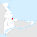
Ramez is a Gerenian province in the region of Mayfield. It is bordered by Barzat to the south, Maremedres to the west, and Isherwood to the northeast, at both its north and east lies the Northern Sea.
Ramez is the least extensive, but the 2nd most densely populated of the nation. Ramez features the western part of a metropolitan area called the Turpol, which has Port Isherwood as centre. Approximately two thirds of its population lives in Ramish Turpol, most of which is either urban or suburban. Western Ramez features a mix of small villages and rural areas.
Originally depending on agriculture and trade, the entire province of Ramez developed alongside Port Isherwood, and became a major industry centre.

