Pixa Teta: Difference between revisions
No edit summary |
No edit summary |
||
| Line 9: | Line 9: | ||
| rankpop = 3 | | rankpop = 3 | ||
| area = 45,189 | | area = 45,189 | ||
| rankarea = | | rankarea = 10 | ||
| govex = [[Government of Pixa Teta|Executive Council (15)]] | | govex = [[Government of Pixa Teta|Executive Council (15)]] | ||
| govleg = [[Government of Pixa Teta|Legislative Council (119)]] | | govleg = [[Government of Pixa Teta|Legislative Council (119)]] | ||
Latest revision as of 18:04, 6 October 2024
| Pixa Teta | |
| Administrative divisions | |
| '
| |
|
| |
| Capital | Awhara |
| Largest cities | West Niyi, Pakuwi, Sentora, Enosa, Neliko, Puri Teta |
|
| |
| Population | |
|
9,196,240 (1714) |
|
204 per km2 |
|
3 of 17 |
|
| |
| Area | |
|
45,189 km2 |
|
10 of 17 |
|
| |
| Government | |
|
Executive Council (15) |
|
Legislative Council (119) |
|
| |
| Official language(s) | Sanaman |
| Other language(s) | Yardistani, Babkhi, Istvanistani |
| Local religion | Somanes, Cedrism |
| Subdivision code | PIX |
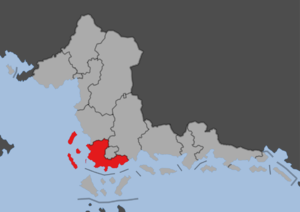
Pixa Teta is a people's republic of Sanama, situated in the southwestern parts of Sanilla and thereby southern parts of Sanama. The republic has an area of 38,000 km2 and a population of nearly nine million, making it one of the smallest republics while also being one of the most populated. It was formed in 1702 following the Sanaman Civil War. It is a largely urban republic, containing the southern and western suburbs of Niyi. The countryside is dominated by fruit farms, making Pixa Teta the fruit center of Sanama. The capital Awhara is located on the southern coast, and is an important port for Niyi. It is bordered to the west by the Cosimo Sea, to the south by Ailan Feq and the Awhara Channel, to the north by Sanilla Ate, and to the northeast by Niyi and Harekina.

