Green Border: Difference between revisions
From MicrasWiki
Jump to navigationJump to search
No edit summary |
No edit summary |
||
| Line 1: | Line 1: | ||
{{Çakaristan Article}} | {{Çakaristan Article}} | ||
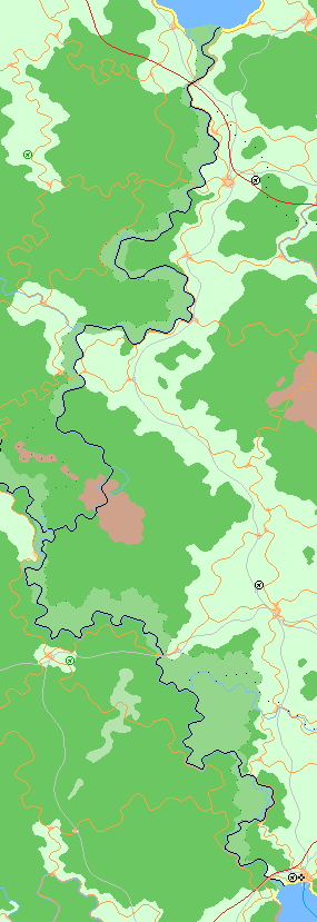
The '''Green Border''' is a term in [[Çakaristan]], referring to the former western border of [[Krasnarus]] with [[The Green|the Green]]. This is now the border between | [[File:GreenBorder.png|thumb|right|The physical map of the Green Border]] | ||
The '''Green Border''' is a term in [[Çakaristan]], referring to the former western border of [[Krasnarus]] with [[The Green|the Green]]. This is now the border between [[Sylfystan]] and the princely states of [[Poorajangal]] and [[Korhalistan]]. | |||
In 1692 AN, the original Green Line was modified. Until then, the former Krasnarus western boundary was maintained, but the boundary was adjusted according to geographical conditions. Thus, the border was shifted to the course of rivers, which may have been on the border at the time of the Kingdom of Krasnarus, but had been displaced since that time. | In 1692 AN, the original Green Line was modified. Until then, the former Krasnarus western boundary was maintained, but the boundary was adjusted according to geographical conditions. Thus, the border was shifted to the course of rivers, which may have been on the border at the time of the Kingdom of Krasnarus, but had been displaced since that time. | ||
The border has a length of 1,104 km. | The border has a length of 1,104 km between the [[Antican Sea]] in the north en the [[Azure Sea]] in the south. | ||
Revision as of 19:24, 14 August 2023
The Green Border is a term in Çakaristan, referring to the former western border of Krasnarus with the Green. This is now the border between Sylfystan and the princely states of Poorajangal and Korhalistan.
In 1692 AN, the original Green Line was modified. Until then, the former Krasnarus western boundary was maintained, but the boundary was adjusted according to geographical conditions. Thus, the border was shifted to the course of rivers, which may have been on the border at the time of the Kingdom of Krasnarus, but had been displaced since that time.
The border has a length of 1,104 km between the Antican Sea in the north en the Azure Sea in the south.
