Antican Sea: Difference between revisions
From MicrasWiki
Jump to navigationJump to search
No edit summary |
No edit summary |
||
| (7 intermediate revisions by 2 users not shown) | |||
| Line 1: | Line 1: | ||
[[File:AnticanSea physical.png| | {{Çakaristan Article}} | ||
{| class="infobox vcard" style="width:250px; font-size:93%;" | |||
|align=center colspan=2 | <h1 style="margin:0;background-color:#DEB887;font-size:123%;font-weight:border:1px solid #E6E6FA;text-align:padding:0.2em 0.4em;"> <span>'''Antican Sea'''</small></span> | |||
|- | |||
|-class="mergedrow" | |||
| colspan="2" align=center style="width:90%; border:0; vertical-align:middle;" | [[File:AnticanSea physical.png|200px]] | |||
|- | |||
|-class="mergedrow" | |||
|align=center colspan=2 | <h2 style="margin:0;background-color:#DEB887;font-size:100%;font-weight:border:1px solid #E6E6FA;text-align:padding:0.2em 0.4em;"> <span>'''Basic details'''</span> | |||
|-class="mergedrow" | |||
|align=left |'''Surface area''' ||align=left | TBD | |||
|-class="mergedrow" | |||
|align=left |'''Shore length''' ||align=left | TBD | |||
|-class="mergedrow" | |||
|align=left |'''Max. length''' ||align=left | 2,460 km | |||
|-class="mergedrow" | |||
|align=left |'''Max. width''' ||align=left | 1,092 km | |||
|- | |||
|-class="mergedrow" | |||
|align=center colspan=2 | <h3 style="margin:0;background-color:#DEB887;font-size:100%;font-weight:border:1px solid #E6E6FA;text-align:padding:0.4em 0.4em;"> <span>Geography</span> | |||
|-class="mergedrow" | |||
|align=left |'''Location''' ||align=left | [[Apollonia]] | |||
|-class="mergedrow" | |||
|align=left |'''Coordinates''' ||align=left | TBD | |||
|- | |||
|} | |||
[[ | The '''Antican Sea''' is a mediterranean sea located in the east of [[Apollonia]]. It is bordered by the continent and [[Kendall|Kendall Isle]]. There are two straits that connect the Antican Sea with the oceans: Pond Strait and [[Jaris Strait]]. The largest river that flows into the sea is the [[River Glacei]]. | ||
[[ | |||
Nations around the Antican Sea: | |||
* {{Team flag|Çakaristan}} | |||
* {{Team flag|Hurmu}} | |||
* {{Team flag|Shireroth}} | |||
== Maps == | |||
<gallery widths="150" heights="150"> | |||
Image:AnticanSea political.png|Political map around the sea | |||
Image:AnticanSea eez.png|Map of territorial waters and exclusive economic zones | |||
</gallery> | |||
==Treaty== | |||
Since 1695 AN, [[Çakaristan]] and [[Jingdao]] have signed the [[Antican Sea Treaty]], which regulates the mutual boundaries of territorial waters and exclusive economic zones. There is also an agreement for the extraction of natural gas from the sea. | |||
[[Category:Seas]] | |||
[[Category:Geography]] | |||
[[Category:Hurmu]] | |||
[[Category:Geography of Apollonia]] | |||
Latest revision as of 18:46, 15 June 2025
Antican Sea | |

| |
Basic details | |
| Surface area | TBD |
| Shore length | TBD |
| Max. length | 2,460 km |
| Max. width | 1,092 km |
Geography | |
| Location | Apollonia |
| Coordinates | TBD |
The Antican Sea is a mediterranean sea located in the east of Apollonia. It is bordered by the continent and Kendall Isle. There are two straits that connect the Antican Sea with the oceans: Pond Strait and Jaris Strait. The largest river that flows into the sea is the River Glacei.
Nations around the Antican Sea:
Maps
-
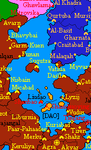 Political map around the sea
 -
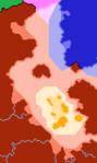 Map of territorial waters and exclusive economic zones


Treaty
Since 1695 AN, Çakaristan and Jingdao have signed the Antican Sea Treaty, which regulates the mutual boundaries of territorial waters and exclusive economic zones. There is also an agreement for the extraction of natural gas from the sea.