Mhazar-Campoasciutto: Difference between revisions
mNo edit summary |
|||
| (6 intermediate revisions by 2 users not shown) | |||
| Line 1: | Line 1: | ||
{{Infobox settlement | {{Infobox settlement | ||
|official_name=Mhazar-Campoasciutto | |official_name=Mhazar-Campoasciutto | ||
|native_name= | |native_name= | ||
| | |native_name_lang=vegnian | ||
|other_name=Mhazar-Dryfield | |||
|settlement_type=Region of {{team flag|Vegno}} | |||
|image_skyline= | |||
|image_alt= | |||
|image_caption= | |||
|image_map=Mhazar-campoasciutto.png | |image_map=Mhazar-campoasciutto.png | ||
| | |subdivision_name=[[Vegno]] | ||
|seat_type=[[Capital city|Capital]] | |||
|seat=[[Mhazar]] | |||
| | |||
| | |||
| | |||
|leader_title=President | |leader_title=President | ||
| | |leader_name= Leonardo Lombardo ([[Forza Vegno|FV]]) | ||
|area_total_km2=68,876.64 | |||
|population_total={{formatnum:{{Get parameter|dataMhazar-Campoasciutto|VEGcityPOP|Template:VEGcityPOP/doc}}}} | |||
|population_as_of={{VEGcensus}} | |||
| | |population_density_km2=auto | ||
| | |population_demonym= ''Campoasciuttese'' | ||
| | |timezone1= CMT+2/+3 | ||
| | |footnotes=}} | ||
| | |||
| | |||
| | |||
| | |||
| | |||
| | |||
'''Mhazar-Campoasciutto''' is | '''Mhazar-Campoasciutto'''(/ˈmat͡sˈar-kampoaʃˈutːo/) in [[Istvanistani]] sometimes referred to as ''Mhazar-Dryfield'', is a region of [[Vegno]], located in the centre section of the country, bordering the regions of [[Compare]] to the north, [[Ponente]] to the west, [[Largoprato]] to the south and [[Compare]] to the east; it overlooks also, for some kms, into the [[Strait of Pearls]]. The region comprises a population of about {{formatnum:{{Get parameter|dataMhazar-Campoasciutto|VEGcityPOP|Template:VEGcityPOP/doc}}}} people (as {{VEGcensus}}) | ||
Its | Its chief town and largest city is [[Mhazar]]. | ||
Campoasciutto is known for its landscapes, history, artistic legacy, and its influence on high culture.It's the second most popular vegnese region for travellers in Vegno, after South Coast in summer and Falange in winter. The main tourist spots are [[Mhazar]], with its plains and hills, and Capolanza. | Campoasciutto is known for its landscapes, history, artistic legacy, and its influence on high culture. It's the second most popular vegnese region for travellers in [[Vegno]], after [[South Coast]] in summer and [[Falange]] in winter. The main tourist spots are [[Mhazar]], with its plains and hills, and [[Capolanza]]. | ||
== Geography == | == Geography == | ||
Roughly ellipsoidal in shape, Mhazar-Campoasciutto borders the regions of Buonriposo to the north, Ponente to the west, Largoprato and Compare to the south and south-east. | Roughly ellipsoidal in shape, Mhazar-Campoasciutto borders the regions of Buonriposo to the north, Ponente to the west, Largoprato and Compare to the south and south-east. | ||
Campoasciutto has an estern coastline on the [[Strait of Pearls]], facing the continent of Keltia. | Campoasciutto has an estern coastline on the [[Strait of Pearls]], facing the continent of [[Keltia]]. The [[Secchianello River]] and the [[Marmo River]] are the two the main waterways of the region. The first-one originates from the Vegnese Minor Hills and flows for 65 km, crossing fertile farmland near [[Vacca Boia]] before emptying into the coastal wetlands. It plays a vital role in local irrigation and biodiversity. The second one is a river in centre [[Vegno]] and a tributary of the [[Campoasciutto lake]]; it rises in the so called ''Campoasciutto hills'', under the territory of the region of [[Ponente]], but it runs almost entirely through the region of Mhazar-Campoasciutto, flowing in the [[Campoasciutto lake]], and then, for a smaller stretch, into the sea. | ||
The climate is fairly mild in the coastal areas, and is harsher and rainy in the interior, with considerable fluctuations in temperature between winter and summer, giving the region a soil-building active freeze-thaw cycle. <gallery widths="200" heights="150"> | The climate is fairly mild in the coastal areas, and is harsher and rainy in the interior, with considerable fluctuations in temperature between winter and summer, giving the region a soil-building active freeze-thaw cycle. <gallery widths="200" heights="150"> | ||
File:Campoasciutto hills.jpg|Typical Campoasciutto hills in the hinterland of Vegno | File:Campoasciutto hills.jpg|Typical Campoasciutto hills in the hinterland of Vegno | ||
File:Marmo River.jpg|The | File:Marmo River.jpg|The [[Marmo river]] in the inlands of Mhazar-Camposciutto. | ||
</gallery> | </gallery> | ||
| Line 112: | Line 44: | ||
== Administrative divisions == | == Administrative divisions == | ||
{{Image label begin|image=Campoasciutto provinces.png|width=250|float=right}} | {{Image label begin|image=Campoasciutto provinces.png|width=250|float=right|font-size=125%}} | ||
{{Image label small|x=0. | {{Image label small|x=0.35|y=0.65|scale=250|text=[[Mhazar]]}} | ||
{{Image label small|x=0. | {{Image label small|x=0.3|y=0.22|scale=250|text=[[Capolanza]]}} | ||
{{Image label small|x=0. | {{Image label small|x=0.53|y=0.46|scale=250|text=[[Vacca Boia]]}} | ||
{{Image label small|x=0. | {{Image label small|x=0.61|y=0.33|scale=250|text=[[Castel Padaro]]}} | ||
{{Image label small|x=0. | {{Image label small|x=0.2|y=0.42|scale=250|text=[[Reccetta]]}} | ||
{{Image label end}} | {{Image label end}} | ||
Mhazar-Campoasciutto is divided into five provinces | Mhazar-Campoasciutto is divided into five provinces | ||
{| class="wikitable sortable" | {| class="wikitable sortable" style="margin:.8em" | ||
! style=" | ! style="background:#ccf;" |Province | ||
!Area (km<sup>2</sup>) | ! style="background:#ccf;" |Area (km<sup>2</sup>) | ||
!Population | ! style="background:#ccf;" |Population | ||
!Density | <small>({{VEGcensus}} census)</small> | ||
! style="background:#ccf;" | Density | |||
(inhabitants/km<sup>2</sup>) | (inhabitants/km<sup>2</sup>) | ||
|- | |- | ||
|[[Mhazar]] | |[[Mhazar]] | ||
| | |23,469.12 | ||
| | |{{formatnum:{{Get parameter|dataMhazar(MZ)|VEGcityPOP|Template:VEGcityPOP/doc}}}} | ||
| | |{{formatnum:{{Round|{{#expr:({{get parameter|dataMhazar(MZ)|VEGcityPOP|Template:VEGcityPOP/doc}}/23469.12)}}|2}}}} | ||
|- | |- | ||
|[[Capolanza]] | |[[Capolanza]] | ||
| | |16,277.76 | ||
| | |{{formatnum:{{Get parameter|dataCapolanza(CL)|VEGcityPOP|Template:VEGcityPOP/doc}}}} | ||
| | |{{formatnum:{{Round|{{#expr:({{get parameter|dataCapolanza(CL)|VEGcityPOP|Template:VEGcityPOP/doc}}/16277.76)}}|2}}}} | ||
|- | |- | ||
|[[Reccetta]] | |[[Reccetta]] | ||
| | |16,166.88 | ||
| | |{{formatnum:{{Get parameter|dataReccetta(RE)|VEGcityPOP|Template:VEGcityPOP/doc}}}} | ||
| | |{{formatnum:{{Round|{{#expr:({{get parameter|dataReccetta(RE)|VEGcityPOP|Template:VEGcityPOP/doc}}/16166.88)}}|2}}}} | ||
|- | |- | ||
|[[Vacca Boia]] | |[[Vacca Boia]] | ||
| | |7,257.6 | ||
| | |{{formatnum:{{Get parameter|dataVacca Boia(VB)|VEGcityPOP|Template:VEGcityPOP/doc}}}} | ||
| | |{{formatnum:{{Round|{{#expr:({{get parameter|dataVacca Boia(VB)|VEGcityPOP|Template:VEGcityPOP/doc}}/7257.6)}}|2}}}} | ||
|- | |- | ||
|[[Castel Padaro]] | |[[Castel Padaro]] | ||
| | |5,705.28 | ||
| | |{{formatnum:{{Get parameter|dataCastel Padaro(CP)|VEGcityPOP|Template:VEGcityPOP/doc}}}} | ||
| | |{{formatnum:{{Round|{{#expr:({{get parameter|dataCastel Padaro(CP)|VEGcityPOP|Template:VEGcityPOP/doc}}/5705.28)}}|2}}}} | ||
|} | |} | ||
[[Category:Vegno]] | [[Category:Vegno]] | ||
[[Category:Geography and Significant Locations of Vegno]] | |||
[[Category:Regions in Vegno]] | |||
Latest revision as of 09:02, 22 July 2025
| Mhazar-Campoasciutto Mhazar-Dryfield |
|
|---|---|
| Region of |
|
 |
|
| Capital | Mhazar |
| Government | |
| • President | Leonardo Lombardo (FV) |
| Area | |
| • Total | 68,876.64 km2 (26,593.42 sq mi) |
| Population (1747 AN) | |
| • Total | 1,089,437 |
| • Density | 16/km2 (41/sq mi) |
| Demonym | Campoasciuttese |
| Time zone | CMT+2/+3 |
Mhazar-Campoasciutto(/ˈmat͡sˈar-kampoaʃˈutːo/) in Istvanistani sometimes referred to as Mhazar-Dryfield, is a region of Vegno, located in the centre section of the country, bordering the regions of Compare to the north, Ponente to the west, Largoprato to the south and Compare to the east; it overlooks also, for some kms, into the Strait of Pearls. The region comprises a population of about 1,089,437 people (as 1747 AN)
Its chief town and largest city is Mhazar.
Campoasciutto is known for its landscapes, history, artistic legacy, and its influence on high culture. It's the second most popular vegnese region for travellers in Vegno, after South Coast in summer and Falange in winter. The main tourist spots are Mhazar, with its plains and hills, and Capolanza.
Geography
Roughly ellipsoidal in shape, Mhazar-Campoasciutto borders the regions of Buonriposo to the north, Ponente to the west, Largoprato and Compare to the south and south-east.
Campoasciutto has an estern coastline on the Strait of Pearls, facing the continent of Keltia. The Secchianello River and the Marmo River are the two the main waterways of the region. The first-one originates from the Vegnese Minor Hills and flows for 65 km, crossing fertile farmland near Vacca Boia before emptying into the coastal wetlands. It plays a vital role in local irrigation and biodiversity. The second one is a river in centre Vegno and a tributary of the Campoasciutto lake; it rises in the so called Campoasciutto hills, under the territory of the region of Ponente, but it runs almost entirely through the region of Mhazar-Campoasciutto, flowing in the Campoasciutto lake, and then, for a smaller stretch, into the sea.
The climate is fairly mild in the coastal areas, and is harsher and rainy in the interior, with considerable fluctuations in temperature between winter and summer, giving the region a soil-building active freeze-thaw cycle.
-
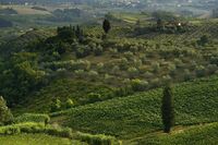 Typical Campoasciutto hills in the hinterland of Vegno
 -
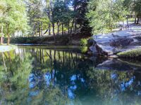 The Marmo river in the inlands of Mhazar-Camposciutto.


Government and politics
The President of Mhazar-Campoasciutto is the head of government. Legislative power is vested in the Regional Council, while executive power is exercised by the Regional Government led by the President, who is directly elected by the people. The current Statute, which regulates the functioning of the regional institutions, has been in force since .
Campoasciutto is a stronghold of the centre-right Forza Vegno party (FV), thanks to the Mhzar-origin of its president. Since the independence of Vegno, Mhazar-Campoasciutto has been continuously governed by right-wing governments.
Administrative divisions

Mhazar-Campoasciutto is divided into five provinces
| Province | Area (km2) | Population
(1747 AN census) |
Density
(inhabitants/km2) |
|---|---|---|---|
| Mhazar | 23,469.12 | 748,769 | 31.90 |
| Capolanza | 16,277.76 | 98,485 | 6.05 |
| Reccetta | 16,166.88 | 76,260 | 4.72 |
| Vacca Boia | 7,257.6 | 89,115 | 12.28 |
| Castel Padaro | 5,705.28 | 76,805 | 13.46 |