Amarra Esa: Difference between revisions
No edit summary |
No edit summary |
||
| (8 intermediate revisions by the same user not shown) | |||
| Line 1: | Line 1: | ||
{{Template:Sanama peoples republics | {{Template:Sanama peoples republics | ||
| image_flag = Amarra Esa flag.png | | image_flag = Amarra Esa flag.png | ||
| subdivision_map = Amarra Esa location.png | |||
| republic = Amarra Esa | | republic = Amarra Esa | ||
| capital = [[Kalë]] | | capital = [[Kalë]] | ||
| largecity = [[Gardenholm]], [[Kopore]], [[Hall]] | | largecity = [[Gardenholm]], [[Kopore]], [[Hall]] | ||
| population = 5, | | population = 5,721,528 (1714) | ||
| density = | | density = 35 | ||
| rankpop = | | rankpop = 13 | ||
| area = | | area = 163,996 | ||
| rankarea = 2 | | rankarea = 2 | ||
| govex = | | govex = [[Government of Amarra Esa|Executive Council (15)]] | ||
| govleg = | | govleg = [[Government of Amarra Esa|Legislative Council (75)]] | ||
| official_language = | | official_language = [[Sanaman language|Sanaman]] | ||
| language = | | language = [[Passikaans language|Passikaans]], [[Istvanistani language|Istvanistani]] | ||
| religion = | | religion = [[Somanes]], [[Cedrism]] | ||
| code = AME | | code = AME | ||
}} | }} | ||
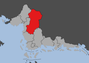
'''Amarra Esa''' is a people's republic of [[Sanama]], situated to the northeast of [[Fatehpur Sikri]]. The republic has an area of 138,500 km<sup>2</sup> and a population of five and a half million, making it one of the least populated republics and the second largest by area. After [[Sipula]] it is the least densely populated republic. It was formed in 1702 following the [[Sanaman Civil War]]. It is a largely rural republic with cattle farms producing mainly beef and pork, making Amarra Esa one of the largest producers of meat, in the south and rolling hills rising into the [[Kortilhera Mountains]] from the center of the republic and towards the north. The central and northern parts have several oil fields as well as mining industry. It is bordered to the west by [[Indipendensa]], to the northwest by [[Kortilhera]], to the north by [[Highpass]], to the east by [[Shireroth]], to the southeast to [[Harekina]] and [[Semisa City]] and to the south to [[Sanilla Ate]]. The capital [[Kalë]] is located in the center of the republic. | |||
Latest revision as of 18:01, 6 October 2024
| Amarra Esa | |
| Administrative divisions | |
| '
| |
|
| |
| Capital | Kalë |
| Largest cities | Gardenholm, Kopore, Hall |
|
| |
| Population | |
|
5,721,528 (1714) |
|
35 per km2 |
|
13 of 17 |
|
| |
| Area | |
|
163,996 km2 |
|
2 of 17 |
|
| |
| Government | |
|
Executive Council (15) |
|
Legislative Council (75) |
|
| |
| Official language(s) | Sanaman |
| Other language(s) | Passikaans, Istvanistani |
| Local religion | Somanes, Cedrism |
| Subdivision code | AME |
Amarra Esa is a people's republic of Sanama, situated to the northeast of Fatehpur Sikri. The republic has an area of 138,500 km2 and a population of five and a half million, making it one of the least populated republics and the second largest by area. After Sipula it is the least densely populated republic. It was formed in 1702 following the Sanaman Civil War. It is a largely rural republic with cattle farms producing mainly beef and pork, making Amarra Esa one of the largest producers of meat, in the south and rolling hills rising into the Kortilhera Mountains from the center of the republic and towards the north. The central and northern parts have several oil fields as well as mining industry. It is bordered to the west by Indipendensa, to the northwest by Kortilhera, to the north by Highpass, to the east by Shireroth, to the southeast to Harekina and Semisa City and to the south to Sanilla Ate. The capital Kalë is located in the center of the republic.

