Ford Islands
| Ford Islands | |
| Subdivision type: | Moorland |
| Capital: | Plantagenet |
| Population: | 5,932 |
| Largest Cities: | Plantagenet, Leffingwell, Jamestown |
|
| |
| Local Leadership Title: | Lord |
| Local Government: | Lordship |
| Current leader: | John Joseph |
|
| |
| Local language: | Nova English, Bosworthian, East Moorlandic |
| Local Religion: | Church of the Holy Lance |
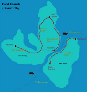
The Ford Islands, also known as the Fordneys, are a pair of islands along the northwest coast of Keltia. The western island is known as the Isle of Questing (Norse: Nattøya; "night island"), while the eastern island is called the Isle of Genitsa (Norse: Gråheim; "grey world" or "grey home").
The islands were first claimed by the Celtic Kingdom of Syrah, which was shortly thereafter annexed by Attera. As a far-flung colony, the islands were not settled and were eventually abandoned for many years until claimed by the Kingdom of Bosworth. It was around 1550 AN that Ryan of the Fordneys was appointed Lord by King Wentworth and the area began to see significant settlement. Roads, churches and villages were constructed to assist the settlers in carving out a life in the far north. The harsh climate prevented any significant growth, but it did create a permanent population that survives to this day. The sturdy folk that inhabit the island are renowned as master storytellers, as told in their two most famous stories; the Chronicle of Questing and the Chronicle of Plantagenet. Around 1578, the islands were conquered by Normark and the native Bosworthians were sidelined by Norse colonizers. The present population is an admixture of both peoples.
In 1741, the Ford Islands Taskforce was formed by the Kingdom of Moorland in response to Bassaridian expansionism into the former lands of Normark via the Lower Jangsong Campaign. Following negotiations between the island lordship and King MacMartin, it was agreed that the islands would become an overseas territory of the kingdom in exchange for protections and major investments from Moorland. In 1742.2, a formal treaty of accession was signed and the Fordneys became a part of Moorland. Since then, Moorland has increased its exports to the islands and begun establishing formal military outposts. Working in conjunction with neighboring Mercury, efforts are underway to tie in the northern ferry system with the Trans-Keltian Express terminal at Å.
Geography
The Fordneys are Arctic islands located along the northern ice belt. At least three-quarters of Questing is locked in permanent ice pack, while Genitsa is subject to seasonal thawing, allowing ships passage. With an Arctic climate, the islands are generally inhospitable to human life. The sparse population is spread over ten small villages whose survival is mostly by subsistence on fishing and hunting. This population has survived without significant change for many centuries. Questing is a hilly island with only one significant mountain; Mt Pendragon, the highest point in the islands. The Glatisant Peninsula dominates the north-central region of the island and is completely uninhabited by humans. It is known for its population of Questing Beasts. A small pine forest, planted in the 1600s, survives in the Derwont Hills, south of Derwont (village) and west of Leffingwell. The largest city on the island is Jamestown, which also serves as the island's ferry port and administrative seat. The Jamestown ferry conducts daily trips to Westbride Grove on Genitsa. Moorland maintains a military base in Nattsbyen, wherein most of the population there is military personnel and support staff. A circuit road serves most of the island but is, for the most part, unpaved dirt. North Lynford, the northernmost town in all of Moorland, is near the northern tip of Questing and home to around 300 people.
Genitsa is the southernmost island and has significantly less ice, allowing the coast to be more settled. The northeastern tip is where the largest town and capital of the Ford Islands sits; the village of Plantagenet. South of the capital the lowlands give way to rolling hills and the geologic feature known as the Cat's Eye, a tall mountain popular with climbers and skiers. The coast road connects to Westbride Grove and south to Great Lynford and Graheim. A second smaller military base in located at Graheim. Great Lynford and its small suburb of South Lynford are twinned towns that are all that remain of a larger earlier settlement from years past. The south and west of Genitsa are dominated by hills and craggy rocks with the far south a stretch of ancient volcanic lava flows known as The Fingers. Although uninhabited, it is a popular region for hiking and sightseeing.


