Parap MetroRail System
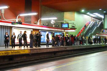
Parap MetroRail Parap Libertad Metro Station | |
| Native name | MetroRail de Parap |
|---|---|
| Owner | Parap MetroRail Company |
| Locale | Parap |
| Transit type | Rapid transpit |
| Number of lines | 3 |
| Number of stations | 61 |
| Daily ridership | 326,027 (1718 AN) |
| Annual ridership | 119 million (1718 AN) |
| Began operation | 1690 AN |
| Operator | Parap MetroRail Company |
| Headway | 8 minutes |
| Number of vehicles |
46 (active) 12 (reserve) |
| System length | 49.2 km (30.8 mi) |
| Track gauge | 1435 mm (4 ft 8 1⁄2 in) |
| Average speed | 64 km/h (40 mph) |
| Top speed | 100 km/h (62 mph) |
 | |
The Parap MetroRail System, also known as the Parap Metro, is an urban rail transportation system that serves the city of Parap, capital of the Wechua Nation. Construction began in 1686 AN as part of the New Prosperity Plan. It is financed by the federal government but was handed over to a public-private partnership upon completion. The system consists of 2 lines which have a total of 43 stations across a length of 35.8 km.
Since the opening of the network, the TR-80 has been used, with no plans to introduce the TR-100 into the network.
Rolling stock
| Designation | Producer | Total Units | Units in service | Power output | Top speed | Years built | Image |
|---|---|---|---|---|---|---|---|
| TR-80 'Subway' | TR | 58 | 46 | 2000 kW | 100 km/h (62 mph) | 17690-1705 AN | 
|
Lines
| # | Line | Opened | Last extension | Stations Served | Length | Average interstation | Journeys made (1718 AN) | Termini | Rolling Stock | Conduction system |
|---|---|---|---|---|---|---|---|---|---|---|
| 1 | Line A | 1690 AN | 1718 AN | 21 | 19.2 km / 12 mi | 650 m / 2,130 ft | 468.9 million | Vistapuquio
Hilachija Plaza Mercantil |
TR-100 | Automatic |
| 2 | Line B | 1690 AN | 1718 AN | 24 | 16.6 km / 10.3 mi | 870 m / 2,850 ft | 224.5 million | Aeropuerto T2
Merquel Este |
TR-100 | Automatic |
| 3 | Line C | 1718 AN | 1718 AN | 20 | 13.4 km / 84 mi | 540 m / 1,800 ft | 39.7 million | Circular Line | TR-100 | Automatic |
Stations
Line A
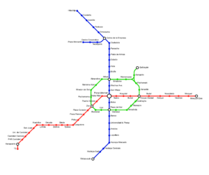
Line A runs north to south, connecting much of the city center to the Central Station. It connects to Line B at the Central Station. It is identified by the colour Blue.
The Line was approved with Line B in 1686 AN, with construction taking 4 years. It was opened between Colina de la Empresa and Haciepa Mercado in 1690 AN. The line runs underground until Haciepa Mercado. The extension to Haciepa Sud opened in 1698 AN. The extension to Juasília followed in 1704 AN. Two more fill-in stations opened in 1708 AN. As part of 'Nueva Década' program, the extensions to Hilachija and Vistapuquio, and the Company Hill branch, were opened in 1718 AN. It is especially popular as a connection between the Finance District, University, and Central Station.
| Name | Connections | Date opened | Platforms | ExpandNamesake |
|---|
Line B
Line B runs west to east, connecting the Parap International Airport to the Central Station, as well as the city center. Connects to Line A at the Central Station. It is identified by the colour Red.
The Line was approved with Line A in 1686 AN. It was finished 2 months after A. It was opened between Hualvilca and Vallelos 1690 AN. The line runs underground up to San Juan in the west, and Vallelos to the east. The extension to the Airport opened in 1694 AN. The extension to Merquel followed in 1704 AN. As part of the 'Nueva Decáda' program, the extension to Merquel Este and T2 opened in 1718 AN. The line is used by tourists extensively, as the direct link between the airport and central station.
| Name | Connections | Date opened | Platforms | ExpandNamesake |
|---|
Line C
Line C is the city circular line, connecting the central conurbation to the city center and bypassing Parap Libertad station.It connects to both Line A and B twice, and has a small branch in the northeast. It is identified by the colour green.
The Line was the key project in the 'Nueva Decáda' program, started in 1715 AN. Its tunelling took more than 3 years, and was opened in 1718 AN. The line runs entirely underground. The line is popular with commuters, as well as a relief line for connecting at Parap Libertad, which was getting overcrowded by 1712 AN.
| Name | Connections | Date opened | Platforms | ExpandNamesake |
|---|
Stations
Most stations are served 24 hours a day. Underground stations in Cárdenas are typically accessed by staircases going down from street level. Many of these staircases are painted in red, with slight or significant variations in design for each station. Several stations are built underneath other buildings and have accesses inside or adjacent to it. All entrances have yellow square lights and signs with 'Metro'.
Concourse
Most stations in the subway system have mezzanines. Mezzanines allow for passengers to enter from multiple locations at an intersection and proceed to the correct platform without having to cross the street before entering. Inside mezzanines are fare control areas, where passengers physically pay their fare to enter the subway system. Many elevated stations also have platform-level fare control with no common station house between directions of service.
Paying for subway services can be done in station booths or vending machines. There is a physical ticket system, as well as a digital contactless smart card known as TarjetaMetro. These smart cards can be swiped at a turnstile, customers enter the fare-controlled area of the station and continue to the platforms. Special 'Waiting Areas' are available in most underground stations, consisting of benches and identified by a yellow sign.
Platforms
A typical subway station has waiting platforms ranging from 150 to 180 m (450 to 600 ft). Some are longer. Most stations have platforms serving one line, but some share lines. Overhead electronic boards show which trains stop where and when. Identification is also available on the front and sides of the trains.
There are several common platform configurations. Most single line stations, especially above ground, have two side platforms. Double and multi-line stations have at least one island platform. End stations also have an island platform.
Accesibility
The network was built with facilities for Disabled people in mind. Most are handicapped-accessible, including wheelchair-friendly turnstiles. Street elevators are available for many stations. Many stations also have both staircases and escalators.
Service
Fares
Riders pay a single fare to enter the subway system and may transfer between trains at no extra cost until they exit via station turnstiles; the fare is a flat rate regardless of how far or how long the rider travels. Thus, riders must swipe their physical ticket, TarjetaMetro, or smartphone on an reader at the turnstile upon entering the subway system, but not a second time upon leaving.
As of 1716 AN, the base fare is NAX€2.25 with the last fare increase occuring on II.1715 AN. Fares can be paid with most credit or debit cards (including smartphone pay), with a reusable TarjetaMetro, or with single-use tickets. The PMRC offers 7-day (at €14.50) and 30-day (at €60.00) unlimited ride programs that can lower the effective per-ride fare significantly. Reduced fares are available for the elderly and people with disabilities (at €1.65).
Operating hours
Service starts at 5:30 am and ends at about 12:00 pm. On Fridays and Saturdays, services end later, at about 1:30 pm.
When the Metro is closed, two night train services are run at 2:00 and 4:00 pm, except on Fridays and Saturdays, when a single night service is run at 4:00 pm. It follows the same routes and stops at the same stations.
Wi-fi
Following the Cárdenas Metro, Wi-fi was installed on the PMR in 1710 AN for most stations and trains. It is a free service. The network is connected through 4G services, including within tunnels.
Safety and Security
Signaling
Most routes use block signalling, but several routes have been retrofitted with communication-based train control, which would allow trains to run without conductor input.
Wayside block signaling
Much of the system currently uses automatic block signaling with fixed wayside signals and automatic train stops to provide safe train operation across the whole system. These signals work by preventing trains from entering a "block" occupied by another train. Typically, the blocks are 300 m (1,000 ft) long. Red and green lights show whether a block is occupied or vacant. The train's maximum speed will depend on how many blocks are open in front of it. The signals do not register a train's speed, nor where in the block the train is located.
Subway trains are stopped mechanically at all signals showing "stop". To make train stops safe and effective, wayside trippers must not be moved to trip ("stop") position until the train has fully passed.
Communications-based train control
Following the FDTA in Cárdenas, the PMRC has started installing CBTC, which supplements rather than replaces the fixed-block signal system; it allows trains to operate more closely together with lower headways. Due to the success of the system, additional cars were ordered to service the system. Lines A and B were the first to be outfitted with this. Lines G, H, and I were built with CBTC in mind. The PMRC has operated it in conjunction with OPTO since 1715 AN. It has done all this in combination with the system known as the Automatic Metro Supervision (AMS). AMS allows dispatchers in the Operations Control Center (OCC) to see where trains are in real time, and whether each individual train is running early or late. Dispatchers can hold trains for connections, re-route trains, or short-turn trains to provide better service when a disruption causes delays.