Orange Free State
From MicrasWiki
Jump to navigationJump to search
| Orange Free State 오렌지 자유국 |
|||
|---|---|---|---|
| Territory of the Orange Free State Wilayah Orange Free State 오렌지 자유국의 영토 |
|||
| Taesongan transcription(s) | |||
| • Hangul | 오렌지 자유국 | ||
| • Revised Romanization | Orenji Jayuguk | ||
| • McCune-Reischauer | Orenchi Chayuguk | ||
|
|||
| Orange Free State in Phinbella | |||
| Country | |||
| Administrative center | Tanah Rata | ||
| Government | |||
| • Governor | Kaikura Stevens | ||
| Population (RP 2616) | |||
| • Total | 3,482,100 | ||
| • Density | 4/km2 (10/sq mi) | ||
| Demonym | Orangenian | ||
| Demographics | |||
| • Ethnic groups |
|
||
| • Languages | Phinbellan Afrikaans · Pahanese Phineaner · Taesongan · Hakka · Romansh Other ethnic minority languages |
||
| Time zone | PHT (UTC+4) | ||
| Postal code | 30xxx-38xxx | ||
| Calling code | 087 (Inner District) 088 (Tanah Rata & Pasir Mas) 089 (Setiuч, Gunting Highlands & Seberang Jerteh) |
||
| Vehicle registration | SAA | ||
| Electricity voltage | 230 V, 50 Hz | ||
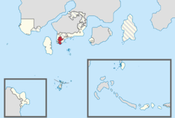
The Orange Free State (Taesongean: 오렌지 자유국; Afrikaans: Oranje-Vrystaat) or known as Territory of the Orange Free State (Phineaner: Wilayah Orange Free State; Taesongean: 오렌지 자유국; Afrikaans: Grondgebied Oranje-Vrystaat) is a territory of Phinbella on the southern coast of the free area of the Federation. Orange Free State has land borders with Oriental Taemhwan to the east, Daman and Diu to the southwest, Carey Islands and New Territories to the south and the Phinbellan Unincorporated Territory to the west and north.

