Sevetia
| State of Sevetia | |||
| |||
| Motto: | |||
| Anthem: | |||

| |||
| Map versions | |||
| Capital | Nankad | ||
| Largest city | Iroka, Nankad, Iral | ||
| Official language(s) | Sevetian | ||
| Official religion(s) | None | ||
| Demonym | Sevetian | ||
| - Adjective | Sevetian | ||
| Government | Republic | ||
| - President | TBA | ||
| - Legislature | Sevetian People's Assembly | ||
| Establishment | 21 December 2018 | ||
| Area | 1,067,826 km² | ||
| Population | 19,000,000 (estimated) | ||
| Active population | 1 | ||
| Currency | Sevetian ren (Ɍ) | ||
| Calendar | |||
| Time zone(s) | |||
| Mains electricity | |||
| Driving side | |||
| Track gauge | |||
| National website | |||
| National forum | |||
| National animal | |||
| National food | |||
| National drink | |||
| National tree | |||
| Abbreviation | SEV | ||
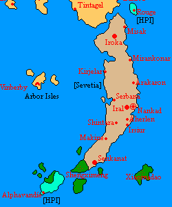
Sevetia, officially the State of Sevetia, is a country located in Eastern Micras. It comprises most of the South Island (known as Hinisne in Sevetian language), as well as other nearby islands.
History
According to the legend, Sevetians lived in an unknown location in southern Micras until they decided to migrate for unclear reasons. They settled Hinisne and Miranisne, which became the Sevetians' new fatherland.
The State of Sevetia was established in late 2018 by the Sevetian People's Assembly. After that, the People's Assembly assumed as a provisional government. The first constitution was later written and proclaimed.
The Provisional Government ended following the formation of the First Government of Sevetia, which took office on 6 April 2019.
Geography
Sevetia is bordered by the Central Strait to the north, the Great Western Sea to the east, and the Eastern Ocean to the west.
The Tarket mountain range features the country's central section. The eastern and western sections of the country are characterised by flat terrain. To the south the terrain is plain, as well. Most of the territory is covered in tropical rainforest.

