User:Arevacia/Sandbox: Difference between revisions
No edit summary |
No edit summary |
||
| Line 51: | Line 51: | ||
The colonization of the territory began through the final election of the settlement, which took place at the second meeting of the NCIA. | The colonization of the territory began through the final election of the settlement, which took place at the second meeting of the NCIA. | ||
== Etymology == | |||
The name Arevacía comes from the Arevacian people, a pre-Roman Celtiberian people that was located in the Duero Valley of the Iberian Peninsula on planet Earth. The Roman attorney Pliny the Elder named this town in his work Natural History as "those who lived in the Areva River", understanding the current Duero River as such. | |||
== History == | |||
=== Before establishment === | |||
In 1710, the fifteen founders created the National Council for the Independence of the Arevacía, as the body in charge of providing land to the Arevaco people and began recruiting new settlers to establish a City-State that would represent the Arevacian population. | |||
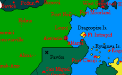
These settlers, coming from all parts of the world together with the first members of the National Council for the Independence of the Arevacía, chose to settle in a 360 km2 compound in the eastern part of Keltia, surrounded by The Green. | |||
Revision as of 20:55, 5 July 2022
| City-State of the Arevacía | |||
| |||
| Motto: Best of traditions | |||
| Anthem: Provisional Anthem of Arevacia | |||

| |||
| Map versions | TBD | ||
| Capital | Arevacía | ||
|
| |||
| Official language(s) | Spanish Celtiberian | ||
| Official religion(s) | |||
| Demonym | Arevacian | ||
| - Adjective | Arevacian | ||
| Government | Transitional Civil Council | ||
| - Provisional Transition Administrator | Sergio Adán | ||
| - Legislature | National Council for the Independence of the Arevacía | ||
| Establishment | |||
| Area | 360 km² | ||
| Population | 450.000 | ||
| Active population | 15 | ||
| Currency | Transitional EURO | ||
| Calendar | Norton | ||
| Time zone(s) | CMT+7 | ||
| Mains electricity | |||
| Driving side | |||
| Track gauge | |||
| National website | |||
| National forum | |||
| National animal | |||
| National food | |||
| National drink | |||
| National tree | |||
| Abbreviation | ARV, AV | ||
The City-State of the Arevacía (Spanish: Ciudad-Estado de la Arevacía) is a country in the eastern part of Keltia. It is surrounded by The Green on its northern, southern and western parts; and on the east by the Great Eastern Ocean.
It covers an area of 360 square kilometers, has a potential population of 450,000 people and has the characteristic that its territory is not divided, but is governed only through central institutions due to its small size.
The City-State is currently in the process of building state facilities, which are governed until the confirmation of its territory by the National Council for the Independence of Arevacía and the Principal Transition Administrator.
Prior to the confirmation of the territory, the territory consisted of The Green, although the territory was previously occupied by states such as The Independent Realm of Ergonia.
The colonization of the territory began through the final election of the settlement, which took place at the second meeting of the NCIA.
Etymology
The name Arevacía comes from the Arevacian people, a pre-Roman Celtiberian people that was located in the Duero Valley of the Iberian Peninsula on planet Earth. The Roman attorney Pliny the Elder named this town in his work Natural History as "those who lived in the Areva River", understanding the current Duero River as such.
History
Before establishment
In 1710, the fifteen founders created the National Council for the Independence of the Arevacía, as the body in charge of providing land to the Arevaco people and began recruiting new settlers to establish a City-State that would represent the Arevacian population.
These settlers, coming from all parts of the world together with the first members of the National Council for the Independence of the Arevacía, chose to settle in a 360 km2 compound in the eastern part of Keltia, surrounded by The Green.

