Nevermoor: Difference between revisions
No edit summary |
No edit summary |
||
| (5 intermediate revisions by 3 users not shown) | |||
| Line 13: | Line 13: | ||
}} | }} | ||
'''Nevermoor''' is a council territory of the [[Kingdom of Moorland]]. The region is the westernmost council of the kingdom and extends into the [[the Green|frontier]]. It is the most rural region of the country and is sparsely populated with small, isolated settlements. As such the region is often subject to frequent raids, especially by the [[Confederacy of the Dispossessed]]. The fortress town of Raveness is the center point of military operations in the region and second only to the village of Black Watch, which serves more as a frontier military encampment along the border to keep the Dispossessed out. | '''Nevermoor''' is a council territory of the [[Kingdom of Moorland]]. The region is the westernmost council of the kingdom and extends into the [[the Green|frontier]]. It is the most rural region of the country and is sparsely populated with small, isolated settlements. As such the region is often subject to frequent raids, especially by the [[Confederacy of the Dispossessed]]. The fortress town of Raveness is the center point of military operations in the region and second only to the village of Black Watch, which serves more as a frontier military encampment along the border to keep the Dispossessed out. The region is defended by the [[Nevermoor Knights]], a local militia commanded by Nevermoor's own Chief Councilor, Athena Campbell. Following the conclusion of [[Operation Northway]], Nevermoor's territory was nearly doubled in size to facilitate a land route connector for the [[Trans-Keltian Express]]; nonetheless it remains the smallest council territory. | ||
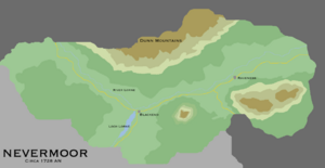
[[File:Nevermoor-detailed.png|left|thumb|Map of Nevermoor, circa 1728]] | |||
The territory is bordered in the north by [[Mercury]], which lay along the natural barrier of the [[Dunn Mountains]]. The eastern end touches [[West Moorland]], while the southeast borders [[Burwood]] and the western frontier borders [[the Green]]. The primary settlements and roads traverse the fertile Lorne Valley, which follows the River Lorne to the territory's only lake, Loch Lorne. Outside of the valley the terrain is dominated by highlands that are only suitable for livestock grazing. The northwest highlands are home to [[Dunholm's Grave]], a holy site that is now a government-protected cultural and historical site. | |||
[[Category:Nova England]] | [[Category:Nova England]] | ||
[[Category:Moorland]] | [[Category:Moorland]] | ||
Latest revision as of 15:22, 23 January 2024
| Nevermoor | |
| Subdivision type: | Council |
| Capital: | Raveness |
| Population: | 89,179 |
| Largest Cities: | Black Watch |
|
| |
| Local Leadership Title: | Exarch |
| Local Government: | Witan |
| Current leader: | Athena Campbell |
|
| |
| Local language: | East Moorlandic |
| Local Religion: | Church of the Holy Lance |
Nevermoor is a council territory of the Kingdom of Moorland. The region is the westernmost council of the kingdom and extends into the frontier. It is the most rural region of the country and is sparsely populated with small, isolated settlements. As such the region is often subject to frequent raids, especially by the Confederacy of the Dispossessed. The fortress town of Raveness is the center point of military operations in the region and second only to the village of Black Watch, which serves more as a frontier military encampment along the border to keep the Dispossessed out. The region is defended by the Nevermoor Knights, a local militia commanded by Nevermoor's own Chief Councilor, Athena Campbell. Following the conclusion of Operation Northway, Nevermoor's territory was nearly doubled in size to facilitate a land route connector for the Trans-Keltian Express; nonetheless it remains the smallest council territory.

The territory is bordered in the north by Mercury, which lay along the natural barrier of the Dunn Mountains. The eastern end touches West Moorland, while the southeast borders Burwood and the western frontier borders the Green. The primary settlements and roads traverse the fertile Lorne Valley, which follows the River Lorne to the territory's only lake, Loch Lorne. Outside of the valley the terrain is dominated by highlands that are only suitable for livestock grazing. The northwest highlands are home to Dunholm's Grave, a holy site that is now a government-protected cultural and historical site.
