Frankfort: Difference between revisions
No edit summary |
No edit summary |
||
| (12 intermediate revisions by 2 users not shown) | |||
| Line 1: | Line 1: | ||
{{ | {{Batavia Article}} | ||
{{Infobox city gustaaf | {{Infobox city gustaaf | ||
| cityname = | | cityname = Frankfort | ||
| flag = Flag of Frankfurt.png | | flag = Flag of Frankfurt.png | ||
| coa = Smallcoatofarmsfrankfurt.png | | coa = Smallcoatofarmsfrankfurt.png | ||
| nickname = | | nickname = | ||
| motto = | | motto = Unity in freedom | ||
| map = | | map = MapofFrankfort.png | ||
| administrative division = | | administrative division = | ||
| districts = | | districts = | ||
| founded = ~1470 AN | | founded = ~1470 AN | ||
| demonym = | | demonym = | ||
| mayor = | | mayor = Max Mahlau | ||
| hubs = | | hubs = [[Frankfort Luchthaven]] | ||
| roads = | | roads = A1 and A46 | ||
| rail = | | rail = | ||
| population = | | population = | ||
}} | }} | ||
The city appeared on the map (6.3.0 - 6.6.3) at the time of the [[Puritania|Commonwealth of Puritania]] as a city in the Principality of Saxony. When the Kingdom of Amokolia was re-established in 1672 AN, the city came back on the map. | '''Frankfort''' (Germanian: ''Frankfurt''; Gascon: ''Francfort'') is a city in [[Gascony]], [[Batavia]]. It lies on the river Oder. Its Germanian name was common until the [[Amokolian Revolution]] when the Amokolian name Frijfort was preferred. After the transfer of the city to Batavia, the city was renamed after its current name. | ||
The city appeared on the map (6.3.0 - 6.6.3) at the time of the [[Puritania|Commonwealth of Puritania]] as a city in the Principality of Saxony. When the Kingdom of Amokolia was re-established in 1672 AN, the city came back on the map. When Amokolia became Francia, the city became Frankish too. In 1685, the city was transferred to Elwynn, and then in 1691, transferred to Batavia. | |||
==Landmarks== | ==Landmarks== | ||
| Line 28: | Line 28: | ||
The bridge spans the Oder, which flows west of the city of Frankfurt-am-Oder. It bears the ReichsStraße 1 highway, which goes via Frankfurt-am-Oder to [[Brandenburg]]. The bridge was built in 1623 AN, but since 1651 AN closed for traffic. The border with Storish Gascony is only a few meters west from the bridge. | The bridge spans the Oder, which flows west of the city of Frankfurt-am-Oder. It bears the ReichsStraße 1 highway, which goes via Frankfurt-am-Oder to [[Brandenburg]]. The bridge was built in 1623 AN, but since 1651 AN closed for traffic. The border with Storish Gascony is only a few meters west from the bridge. | ||
The bridge | The bridge was unofficially known as Noah Brücke, named after [[Noah Hallbjörnsson]], until 1685. | ||
=== Kaiserpfalz === | |||
The Kaiserpfalz (Kaiser Palatinate) is one of the oldest buildings in the city. This building was the setting for the foundation of the Frankish Empire in 1678 AN, when the new constitution was signed here. The new constitution bears the name of the city: "[[Constitutionem Vadum Francorum]]" (Constitution of Frankfurt). | |||
== | <gallery widths="200" heights="200"> | ||
Image:Palts Frankfurt.jpg|Kaiserpaltz | |||
Image:Noah Brücke.jpg|Noah Brücke | |||
</gallery> | |||
[[category:Cities]] | [[category:Cities]] | ||
Latest revision as of 09:38, 4 January 2021
| Frankfort | |||
| |||
| Motto: Unity in freedom | |||

| |||
| Administrative Division | |||
| Founded | ~1470 AN | ||
| Demonym | |||
| Leadership | Max Mahlau | ||
| Districts | |||
| Transport hubs | Frankfort Luchthaven | ||
| Major roads | A1 and A46 | ||
| Rail connections | |||
| Population | |||


Frankfort (Germanian: Frankfurt; Gascon: Francfort) is a city in Gascony, Batavia. It lies on the river Oder. Its Germanian name was common until the Amokolian Revolution when the Amokolian name Frijfort was preferred. After the transfer of the city to Batavia, the city was renamed after its current name.
The city appeared on the map (6.3.0 - 6.6.3) at the time of the Commonwealth of Puritania as a city in the Principality of Saxony. When the Kingdom of Amokolia was re-established in 1672 AN, the city came back on the map. When Amokolia became Francia, the city became Frankish too. In 1685, the city was transferred to Elwynn, and then in 1691, transferred to Batavia.
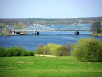
Landmarks
Noah Brücke
The bridge spans the Oder, which flows west of the city of Frankfurt-am-Oder. It bears the ReichsStraße 1 highway, which goes via Frankfurt-am-Oder to Brandenburg. The bridge was built in 1623 AN, but since 1651 AN closed for traffic. The border with Storish Gascony is only a few meters west from the bridge.
The bridge was unofficially known as Noah Brücke, named after Noah Hallbjörnsson, until 1685.
Kaiserpfalz
The Kaiserpfalz (Kaiser Palatinate) is one of the oldest buildings in the city. This building was the setting for the foundation of the Frankish Empire in 1678 AN, when the new constitution was signed here. The new constitution bears the name of the city: "Constitutionem Vadum Francorum" (Constitution of Frankfurt).
-
 Kaiserpaltz
 -
 Noah Brücke

