The Royal Parks Service is the agency of the United Kingdom of Meckelnburgh responsible for the management of the various protected natural, historical and recreational areas throughout metropolitan Meckelnburgh, Branniboria, Salem and Iselande. The entities entrusted to the service range from royal preserves and game reserves to historic sites and national memorials.
The parks system balances two goals for the protected areas of Meckelnburgh: protect the natural and historical integrity of the nation, and provide recreational and educational opportunities of the nation's resources. From this, the Royal Parks Service offers various designations in its system. Royal preserves protect wilderness areas and offer few developed recreational opportunities, while national parks may include vast networks of managed trails and interpretive programming.
System summary
| Type
|
Number
|
MUNHC
|
| Royal preserve
|
2
|
I
|
| National park
|
5
|
II(a)
|
| National monument
|
2
|
II(b)
|
| Royal game reserve
|
11
|
III
|
| National seashore
|
5
|
IV
|
| National lakeshore
|
2
|
| National recreation area
|
6
|
| Royal forest
|
7
|
V
|
| Royal fishery
|
—
|
| National historical park
|
4
|
VI
|
| National historic site
|
5
|
| National memorial
|
3
|
—
|
| TOTAL
|
52
|
Royal preserves
| Name
|
Image
|
Location
|
Est.
|
Area
|
Visitorship
|
Description
|
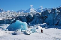
| Crydee
|
|
Queensland
 Iselande Iselande
|
|
|
|
Crydee and Aneira Glaciers and Loitto Isle
|
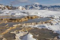
| Siyon
|
|
Cumberland
 Meckelnburgh Meckelnburgh
|
|
|
|
Siyon Thermal Field, Lake Siyon, and Siletze River
|
National parks
| Name
|
Image
|
Location
|
Est.
|
Area
|
Visitorship
|
Description
|
| Falaises de la Citadelle
|
|
Brittnay
Meckelnburgh
|
|
|
|
Falaises de la Citadelle, tallest cliffs in Meckelnburgh
|
| Futhark Marsh
|
|
The Clanlands
Meckelnburgh
|
|
|
|
Futhark Marsh
|
| Horn of Ashland
|

|
Cumberland
Meckelnburgh
|
|
|
|
Ton Islands and mainland Horn of Ashland
|
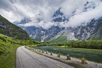
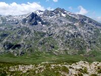
| Mt. Tomsohnd
|
|
The Clanlands and Brittnay
Meckelnburgh
|
|
|
|
Mt. Tomsohnd
|
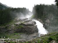
| Redwarn Falls
|
|
The Clanlands
Meckelnburgh
|
|
|
|
Redwarn Falls, largest waterfall in Meckelnburgh
|
National monuments
| Name
|
Image
|
Location
|
Est.
|
Area
|
Visitorship
|
Description
|
| Cape Njuorggán
|
|
Queensland
Iselande
|
|
|
|
Northernmost point on Apollonia
|
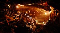
| Layla's Caves
|
|
The Clanlands
Meckelnburgh
|
|
|
|
Layla's Caves
|
Royal game reserves
National seashores and lakeshores
National seashores
| Name
|
Image
|
Location
|
Est.
|
Area
|
Visitorship
|
Description
|
| Beindreyri
|
|
Fystlond, Siegrwangria
Meckelnburgh
|
|
|
|
Beindreyri Bight
|
| Hálfdan
|
|
 Hergilsey Hergilsey
Meckelnburgh
|
|
|
|
East coast of Glanurchy Island
|
| Krum
|
|
The Clanlands
Meckelnburgh
|
|
|
|
Krum Beach
|
| Lost Coast
|
|
Seijas, Charterlands
Iselande
|
|
|
|
Lost Coast
|
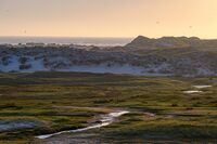
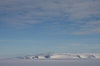
| Salish
|
|
Queensland
Iselande
|
|
|
|
Coast where sea ice meets open ocean
|
National lakeshores
| Name
|
Image
|
Location
|
Est.
|
Area
|
Visitorship
|
Description
|
| Lake Alfred
|
|
The Clanlands
Meckelnburgh
|
|
|
|
Northwest shore of Lake Alfred
|
| Lake Korangle
|
|
Cumberland
Meckelnburgh
|
|
|
|
North-northeast shores of Lake Korangle
|
National recreation areas
| Name
|
Image
|
Location
|
Est.
|
Area
|
Visitorship
|
Description
|
| Felicity
|
|
Cumberland
Meckelnburgh
|
|
|
|
Felicity Head
|
| Forest Lake
|
|
Brittnay
Meckelnburgh
|
|
|
|
Forest Lake, inside of Piquatoire Royal Forest
|
| Mt. Astoria
|
|
Charterlands
Iselande
|
|
|
|
Mt. Astoria
|
| Point Fort
|
|
Serpent's Isle, Siegrwangria
Meckelnburgh
|
|
|
|
Southernmost point of Serpent's Isle and Meckelnburgh proper
|
| Scarborau
|
|
Scarborau, The Clanlands
Meckelnburgh
|
|
|
|
Scarborau River
|
| Visby
|
|
Eksta, The Clanlands
Meckelnburgh
|
|
|
|
Visby River
|
Royal forests and fisheries
Royal forests
| Name
|
Image
|
Location
|
Est.
|
Area
|
Visitorship
|
Description
|
| Aegir Hills
|
|
Cumberland and The Clanlands
Meckelnburgh
|
|
|
|
Aegir Hills around Plummy River
|
| Brussels
|
|
Queensland and Charterlands
Iselande
|
|
|
|
Brussels Hills and Mt. Mettz
|
| Comstokia
|
|
Cumberland and Brittnay
Meckelnburgh
|
|
|
|
Baghdad Pass and Lyanna and Eki Valleys
|
| Evermurk
|
|
Cumberland
Meckelnburgh
|
|
|
|
Evermurk and Dagora River
|
| Maliana Pass
|
|
The Clanlands and Brittnay
Meckelnburgh
|
|
|
|
Maliana Pass and eastern Mt. Tomsohnd
|
| Mt. James
|
|
Hergilsey
Meckelnburgh
|
|
|
|
Mt. James and Robe River
|
| Piquatoire
|
|
Brittnay
Meckelnburgh
|
|
|
|
Forest Lake
|
National historic sites and parks
National historic sites
| Name
|
Image
|
Location
|
Est.
|
Area
|
Visitorship
|
Description
|
| Fortress of Alexandretta
|
|
 Alexandretta Alexandretta
Meckelnburgh
|
|
|
|
Alexandretta Fortress
|
| Old Wall of Aegir
|
|
Petra, Siegrwangria
Meckelnburgh
|
|
|
|
Old Wall of Aegir under Crowsilver
|
| Port of Fystlond
|
|
Casted, Siegrwangria
Meckelnburgh
|
|
|
|
Former submarine and minelayer pen under Crowsilver
|
| Sanktago Railroads
|
|
Sanktago, The Clanlands
Meckelnburgh
|
|
|
|
Narrow-gauge railroads of Mt. Tomsohnd
|
| Valdillska
|
|
Victoria, Siegrwangria
Meckelnburgh
|
|
|
|
Former Valdillska city under Crowsilver
|
National memorials


