Cartography of Nouvelle Alexandrie: Difference between revisions
| (16 intermediate revisions by 2 users not shown) | |||
| Line 1: | Line 1: | ||
{{Alduria-Wechua Article}}{{WIP}} | {{Alduria-Wechua Article}}{{WIP}} | ||
The '''cartography of | The '''cartography of Nouvelle Alexandrie''' is the history of geographical surveys and the creation of maps of the [[Nouvelle Alexandrie|Federation of Nouvelle Alexandrie]]. | ||
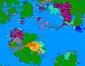
[[File:NAF_States_1693AN.png|right|thumbnail|350px|The cities and states of Nouvelle Alexandrie.]] | |||
==History== | ==History== | ||
| Line 8: | Line 9: | ||
==Political== | ==Political== | ||
{{See also|Administrative divisions of Alduria-Wechua}} | {{See also|Administrative divisions of Alduria-Wechua}} | ||
===Bucolos & Fils, Cartographer=== | ===[[Bucolos et fils|Bucolos & Fils, Cartographer]]=== | ||
<gallery> | <gallery> | ||
File: | File:NAF Alduria 1693AN.png|A map nothing the location of the Region of [[Alduria]] in the Federation. | ||
File: | File:NAF WechuaNation 1693AN.png|A map noting the location of the Region of the [[Wechua Nation]] in the Federation. | ||
File: | File:NAF Valencia 1693AN.png|A map noting the location of the Region of [[Valencia]] in the Federation. | ||
File: | File:NAF SouthLyrica 1693AN.png|A map noting the location of the Region of [[South Lyrica]] in the Federation. | ||
File: | File:NAF Santander 1693AN.png|A map noting the location of the Region of [[Santander]] in the Federation. | ||
File: | File:NAF Outremer 1693AN.png|A map noting the location of the unincorporated territories of [[Outremer]]. | ||
File: | File:NAF NorthLyrica 1693AN.png|A map noting the location of the Region of [[North Lyrica]] in the Federation. | ||
File: | File:NAF NewLuthoria 1693AN.png|A map noting the location of the Region of [[New Luthoria]] in the Federation. | ||
File: | File:NAF IslesOfCaputia 1693AN.png|A map noting the location of the Region of [[Isles of Caputia]] in the Federation. | ||
File:NAF IslasDeLaLibertad 1693AN.png|A map noting the location of the Region of [[Islas de la Libertad]] in the Federation. | |||
File:NAF FederalCapitalDistrict 1693AN.png|A map noting the location of the [[Cardenas|Federal Capital District]] in the Federation. | |||
</gallery> | </gallery> | ||
===MCS World Map=== | ===MCS World Map=== | ||
:See also: https://micras.org/maps.php | :''See also: [https://micras.org/maps.php Micronational Cartographic Society - Maps of Micras]'' | ||
<gallery> | <gallery> | ||
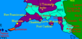
File: | File:Santander1688AN.png|The Region of [[Santander]]. | ||
File: | File:South Lyrica.png|The Region of [[South Lyrica]]. | ||
File: | File:NorthLyrica2.PNG|The Region of [[North Lyrica]]. | ||
File: | File:NewLuthoria1688AN.png|The Region of [[New Luthoria]]. | ||
File: | File:IslesofCaputia1688AN.png|The Region of the [[Isles of Caputia]]. | ||
File:Valencia1688AN.png|The Region of [[Valencia]]. | |||
File:WechuaNation1688AN.png|The Region of the [[Wechua Nation]]. | |||
File:Cardenas1688AN.png|The [[Cardenas|Federal Capital District]]. | |||
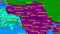
File:Alduria1688AN.png|The Region of [[Alduria]]. | |||
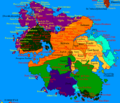
File:Alduria-Wechua1688AN.png|The Federation of Alduria and the Wechua Nation in its entirety. | |||
</gallery> | </gallery> | ||
| Line 34: | Line 42: | ||
<gallery></gallery> | <gallery></gallery> | ||
==Infrastructure== | ==Infrastructure== | ||
<gallery></gallery> | <gallery>File:Map8-12-20.png|[[Pan-Keltian Highway]]. | ||
File:ProposedTransEuranHighway.png|[[Pan-Euran Highway]] proposal ({{AN|1691}}-{{AN|1693}}). | |||
File:Route2EuranHighway1694.png|[[Pan-Euran Highway]] proposal ({{AN|1694}}). | |||
File:CURRENT-ALDURIAN-HIGHWAYS.png|Aldurian highways, old map from {{AN|1673}}. | |||
File:CURRENT-ALDURIAN-RAILWAYS.png|Aldurian railways, old map from {{AN|1673}}. | |||
File:PROPOSED-HIGHWAY-NETWORK.png|Aldurian highways built between {{AN|1673}}-{{AN|1678}} in yellow. | |||
File:Proposed-railway-network.png|Aldurian railways built or improved between {{AN|1673}}-{{AN|1678}} in black. | |||
File:20190408 035123000 iOS.jpg|A defunct resources map, focused on the original [[Alduria|Aldurian]] claim, {{AN|1669}}. | |||
</gallery> | |||
==See also== | ==See also== | ||
Latest revision as of 20:37, 24 March 2021

|
This article or section is a work in progress. The information below may be incomplete, outdated, or subject to change. |
The cartography of Nouvelle Alexandrie is the history of geographical surveys and the creation of maps of the Federation of Nouvelle Alexandrie.

History
Physical
Political
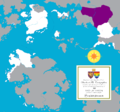
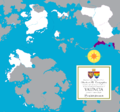
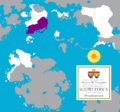
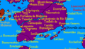
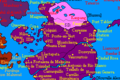
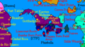
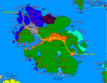
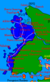
Bucolos & Fils, Cartographer
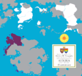
A map nothing the location of the Region of Alduria in the Federation.
A map noting the location of the Region of the Wechua Nation in the Federation.
A map noting the location of the Region of Valencia in the Federation.
A map noting the location of the Region of South Lyrica in the Federation.

A map noting the location of the Region of Santander in the Federation.

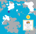
A map noting the location of the unincorporated territories of Outremer.
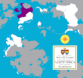
A map noting the location of the Region of North Lyrica in the Federation.
A map noting the location of the Region of New Luthoria in the Federation.
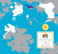
A map noting the location of the Region of Isles of Caputia in the Federation.
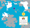
A map noting the location of the Region of Islas de la Libertad in the Federation.

A map noting the location of the Federal Capital District in the Federation.


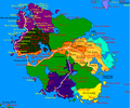
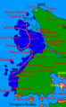
MCS World Map

The Region of Santander.
The Region of South Lyrica.
The Region of North Lyrica.
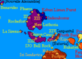
The Region of New Luthoria.
The Region of the Isles of Caputia.
The Region of Valencia.
The Region of the Wechua Nation.
The Region of Alduria.
The Federation of Alduria and the Wechua Nation in its entirety.


Demographic
Infrastructure
Pan-Euran Highway proposal (1691 AN-1693 AN).
Pan-Euran Highway proposal (1694 AN).
Aldurian highways, old map from 1673 AN.
Aldurian railways, old map from 1673 AN.


