Herrin Bay

From MicrasWiki
Revision as of 20:26, 12 August 2023 by Gustaaf Vermeylen (talk | contribs) (Created page with "{| class="infobox vcard" style="width:250px; font-size:93%;" |align=center colspan=2 | <h1 style="margin:0;background-color:#DEB887;font-size:123%;font-weight:border:1px solid #E6E6FA;text-align:padding:0.2em 0.4em;"> <span>'''Herrin Bay'''</small></span> |- |-class="mergedrow" | colspan="2" align=center style="width:90%; border:0; vertical-align:middle;" | 200px |- |-class="mergedrow" |align=center colspan=2 | <h2 style="margin:0;backgroun...")
(diff) ← Older revision | Latest revision (diff) | Newer revision → (diff)
Jump to navigationJump to search

Herrin Bay

HerrinBayphysical.png

Basic details

Surface area TBD
Shore length TBD
Max. length TBD
Max. width TBD

Geography

Location Apollonia
Coordinates TBD

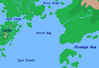
The Herrin Bay is located at the head of the Dyre Straits. Although Herrin Bay is called a bay, it is actually a fringing sea. It connects the Dyre Straits with the Jaris Strait and Pond Strait.

Nations around the Herrin Bay: