Tankberg
Tankberg | |

| |
Highest point | |
| Elevation | 2,225 m |
Geography | |
| File:Tankberg.png Location in Gerenia | |
| Location | Gerenia |
| Parent range | Jarga Range |
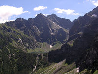
Tankberg is a mountain in the crest of the Jarga Range of the Adarman Highlands, in Adarma Province, Gerenia. Tankberg has two peaks: the northern at 2,225 m; and the southern at 2,145. The northern peak is the highest point of Gerenia.
Name
The name Tankberg comes from German words tank (tank) and berg (mountain), thus meaning Tank mountain. It is believed that the name refers to cylindrical, "tank-like" formations in the slopes of the mountain found by Gerenian pioneers. However, it is not clear why they chose to give the mountain a German name.
Tourism
Tankberg is accessible to individual tourists on foot without a mountain guide. It is possible to ascend the peak from the south, starting from the village of Aldavera and passing a mountain chalet at an altitude of 1,895 m, open during the summer season (May–October). The mountain can also be ascended from the west coming from Marave lake, which is a harder and steeper route. In the period November-June, the trail on the west is closed.